The 10 most popular cycling tours in North America (USA and Canada)
Compare ten classic US and Canadian bike tours by length, days, surface, season and wind, and pick the one that fits your trip.
The short answer
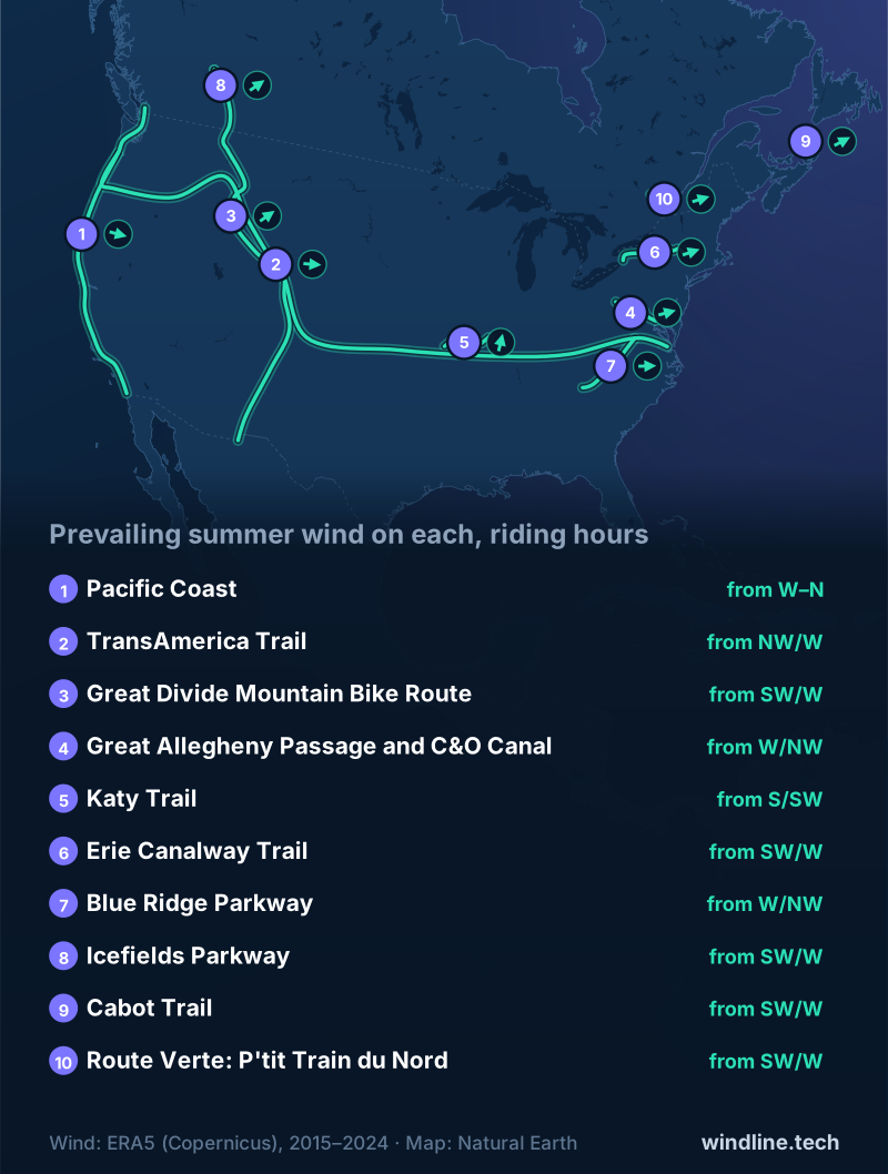
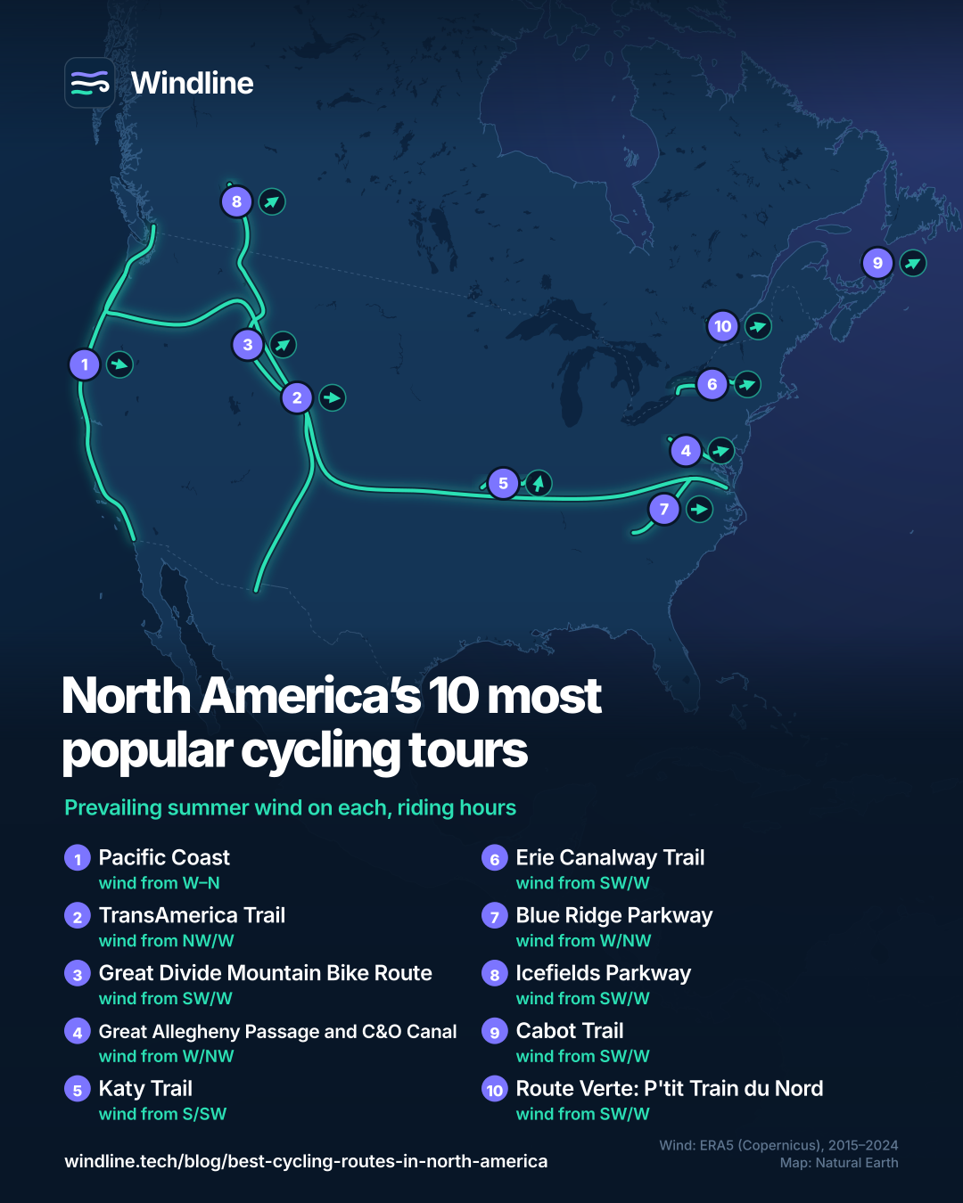
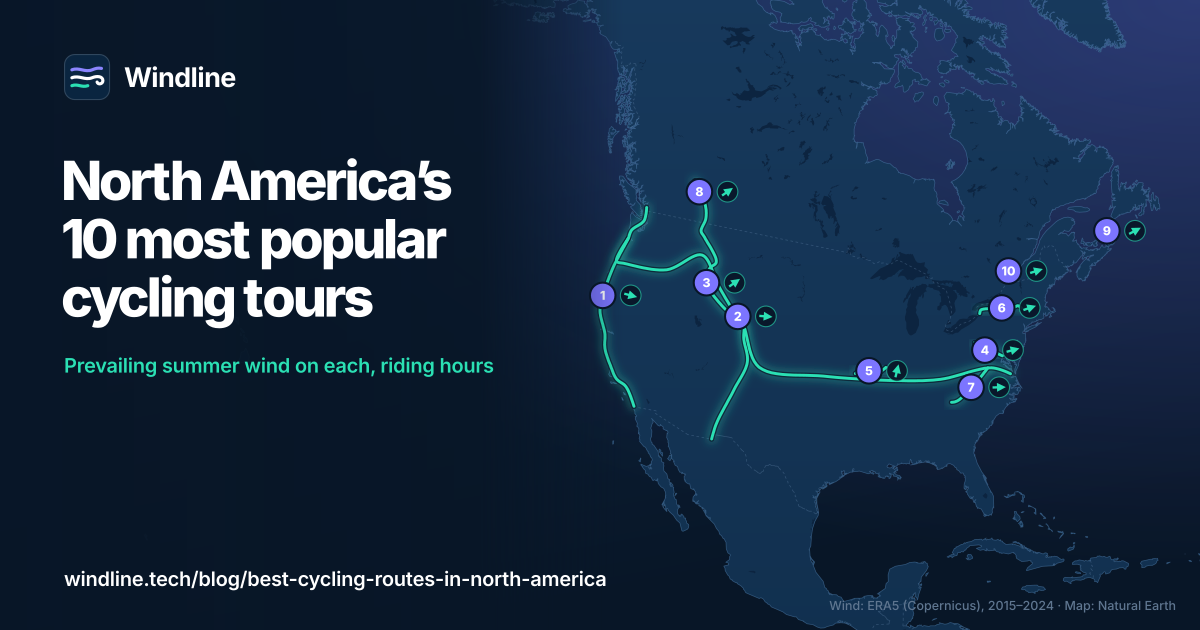
The best cycling routes in North America are the Pacific Coast, the TransAmerica Trail, the Great Divide, the Great Allegheny Passage and C&O Canal, the Katy Trail, the Erie Canalway, the Blue Ridge Parkway, and Canada's Icefields Parkway, Cabot Trail and Route Verte. Most are best ridden between May and October.
Key takeaways
- Three routes are almost entirely car-free: the GAP and C&O, the Katy Trail and the P'tit Train du Nord.
- The TransAmerica Trail runs 6,767 km (4,205 miles) and takes about three months.
- Canada's three routes run 232–298 km (144–185 miles), three to five days each.
- Lengths come from each route's managing body; the winds come from Windline's own ten-year analysis.
Definitions
- Rail trail
- A path built on a disused railway line, usually gently graded and closed to motor traffic.
- Towpath
- The path beside a canal where horses once towed the boats, now often a car-free trail.
- Parkway
- A scenic road managed as a park, built for leisure driving rather than through traffic.
How did we choose the best cycling routes in North America?
We kept routes that a managing body maps or runs, with a published length and season, then balanced them by type and country. Our guide to the world's great cycling routes uses the same test.
We quote official visitor counts where they exist, and never estimate rider numbers. Three routes lie wholly in Canada.
How do the ten routes compare?
Figures are official where published; the method explains the rest.
| Route | Country | Length, km (miles) | Usual days | Surface | Best months | Prevailing wind (May–Sep, riding hours) |
|---|---|---|---|---|---|---|
| Pacific Coast | Canada, US | 2,998 (1,863) | 5–7 weeks | Paved roads | May, Sep–Oct | W to N, 12 km/h (7 mph) |
| TransAmerica Trail | US | 6,767 (4,205) | About 3 months | Paved roads | May–Sep | NW or W, 12 km/h (7 mph) |
| Great Divide | Canada, US | 4,985 (3,097) | 9+ weeks | About 70% unpaved | Jun–Oct | SW or W, 10 km/h (6 mph) |
| GAP and C&O Canal | US | 536 (333) | 4–9 days | Car-free limestone, dirt | Mid-Apr–mid-Nov | W or NW, 9 km/h (6 mph) |
| Katy Trail | US | 386 (240) | 4–6 days | Car-free limestone | Spring, autumn | S or SW, 10 km/h (6 mph) |
| Erie Canalway Trail | US | 580 (360) | 7–9 days | Mostly paved trail | Summer | SW or W, 11 km/h (7 mph) |
| Blue Ridge Parkway | US | 755 (469) | 10–12 days | Road, no bike lanes | Spring–autumn | W or NW, 8 km/h (5 mph) |
| Icefields Parkway | Canada | 232 (144) | 3–4 days | Road, wide shoulder | Jun–Sep | SW or W, 7 km/h (4 mph) |
| Cabot Trail | Canada | 298 (185) | 4–5 days | Road, steep climbs | Summer–mid-Oct | SW or W, 16 km/h (10 mph) |
| P'tit Train du Nord (Route Verte) | Canada | 234 (145) | 3–4 days | Asphalt, stone dust | Summer–Oct | SW or W, 11 km/h (7 mph) |
Want this for your own route? Windline shows the wind for every stretch, timed to your pace. Free. Make a free ride page →
Which long-distance routes suit a big trip?
These take weeks or months, and suit riders with time and touring experience.
Pacific Coast: Vancouver to Imperial Beach
The Adventure Cycling Association (ACA) line runs 2,998 km (1,863 miles) to the Mexican border, mostly paved, with hiker/biker sites in many state parks. The ACA's best months are May and September to October. Wind: Between west and north, averaging 12 km/h (7 mph). More in north or south.
TransAmerica Trail: Astoria to Yorktown
The 1976 Bikecentennial route crosses ten states over 6,767 km (4,205 miles). The ACA suggests about three months, May to September; snow can fall in the Rockies at any time. Wind: North-west or west, averaging 12 km/h (7 mph). See east or west.
Great Divide: Jasper to Antelope Wells
The classic bikepacking route follows the Rockies for 4,985 km (3,097 miles), about 70% unpaved, from Alberta to New Mexico. Towns are two to three days apart on most of it. Wind: South-west or west, averaging 10 km/h (6 mph). Read our Great Divide guide first.
Where can you ride away from cars?
On these three trails, the best first tours on the list.
GAP and C&O Canal: Pittsburgh to Washington, DC
The GAP's 241 km (150 miles) of packed limestone climb gently to the Eastern Continental Divide. The C&O Towpath adds 297 km (184.5 miles) of dirt, muddy after heavy rain. Wind: West or north-west, averaging 9 km/h (6 mph). Plan it with our GAP and C&O guide.
Katy Trail: Machens to Clinton, Missouri
America's longest rails-to-trails project follows an old railway for 386 km (240 miles), mostly level and much of it near the Missouri River. Visit Missouri recommends spring and autumn. Wind: South or south-west, averaging 10 km/h (6 mph).
Erie Canalway Trail: Buffalo to Albany
This signed, mostly paved trail crosses New York State for 580 km (360 miles), with some on-street stretches. It's part of the 1,207 km (750-mile) Empire State Trail. Wind: South-west or west, averaging 11 km/h (7 mph).
Which parkways are worth riding?
Two scenic roads built for cars, so you share them with traffic.
Blue Ridge Parkway: Virginia and North Carolina
The NPS road runs 755 km (469 miles) between Shenandoah and Great Smoky Mountains national parks, with no bike lanes and over two dozen tunnels. Ice often closes parts in winter. Wind: West or north-west, averaging 8 km/h (5 mph).
Icefields Parkway: Lake Louise to Jasper, Alberta
Parks Canada's 232 km (144 miles) road crosses two passes, topping out at 2,070 m (6,791 ft). It's busy in summer, so ride before 10:00 or after 17:00. Wind: South-west or west, averaging 7 km/h (4 mph).
Which Canadian routes suit which riders?
The Cabot Trail suits strong riders; the P'tit Train du Nord suits almost anyone.
Cabot Trail: Cape Breton Island, Nova Scotia
Tourism Nova Scotia gives this loop as 298 km (185 miles). Parks Canada rates North Mountain's grade at 12–15%. Late September to mid-October is popular for autumn colour. Wind: South-west or west, averaging 16 km/h (10 mph). Compare Scotland's North Coast 500.
P'tit Train du Nord: Quebec's Route Verte
Vélo Québec's Route Verte network tops 5,000 km (3,100 miles). Its best-known tour is this 234 km (145-mile) Laurentian rail trail, Saint-Jérôme to Mont-Laurier, with luggage transport available. Wind: South-west or west, averaging 11 km/h (7 mph).
Which one should you pick?
Match the route to your time, fitness and season.
- First tour: the Katy Trail, the GAP and C&O, or the P'tit Train du Nord.
- One summer week: the Icefields Parkway or the Cabot Trail.
- Spring or autumn: the Katy Trail, the GAP and C&O, or the Blue Ridge.
- Months free: the TransAmerica Trail or the Pacific Coast.
- Remote and off-road: the Great Divide.
If you loved Europe's river routes, such as the Danube or the Loire, the towpaths and rail trails are the closest match: flat, signed and sociable. So is New Zealand's Otago Central Rail Trail. See our Europe list.
How should you plan any of them?
Plan the days, then the direction, then each day's weather.
- Split the distance with how far you can cycle in a day and planning a multi-day tour.
- Choose a direction with our prevailing winds guide.
- Read a route-timed forecast, which shows the wind for each stretch at the hour you'll reach it.
Frequently asked questions
Which of these routes has the most users?
The Erie Canalway Trail, on published counts: Parks & Trails New York estimated 3.66 million visits in 2025. The Great Allegheny Passage reports 800,000 to 1.4 million visits a year, and the P'tit Train du Nord more than a million users a year (Government of Canada, 2016). Most are day visits.
Do you need a park pass to cycle the Icefields Parkway?
Yes. Parks Canada requires a park pass on the Icefields Parkway, which runs through Banff and Jasper national parks. Buy it before you go: there's no cell coverage beyond Athabasca Falls, and campgrounds, two with shared bike-camping areas, open in summer only.
Where can you camp cheaply on these routes?
Many Pacific Coast state parks have hiker/biker sites, though the Adventure Cycling Association warns that some charge a full tent price. The C&O Canal has hiker-biker campsites from Swains Lock to Cumberland. Our guide to [wild camping rules](/blog/wild-camping-rules-by-country/) covers public land.
Which route is best for riders who hate climbing?
The Katy Trail, which Visit Missouri calls mostly level over its 386 km (240 miles). The GAP climbs gently to the Eastern Continental Divide, and the P'tit Train du Nord is gently graded. Avoid the Cabot Trail, where Parks Canada rates North Mountain at 12–15%.
Is the Blue Ridge Parkway safe to cycle?
With care. The National Park Service says the parkway has no bike lanes, and cyclists need lights or reflectors in its tunnels, where drivers struggle to see them. Fog and rain can arrive suddenly, and some climbs gain more than 300 m (1,000 ft) in a few miles. Ride in daylight, brightly dressed.
Get the wind for your ride.
Upload a GPX, add your start time and pace, and see the headwind, gusts, rain and heat for every stretch of the route, timed to when you’ll be there. Free for riders.
Make a free ride page →Sources and method
- Adventure Cycling Association (2026). Pacific Coast route
- Adventure Cycling Association (2026). TransAmerica Trail
- Adventure Cycling Association (2026). Great Divide Mountain Bike Route
- Great Allegheny Passage Conservancy (2026). The Ride of Your Life (Pittsburgh to Washington, DC, itinerary)
- Great Allegheny Passage Conservancy (2026). Research and resources (trail visits)
- Allegany County, Maryland (2026). Great Allegheny Passage
- US National Park Service (2026). C&O Canal Mile 0
- US National Park Service (2026). Chesapeake & Ohio Canal: biking
- US National Park Service (2026). Katy Trail State Park
- Visit Missouri (Missouri Division of Tourism) (2026). How to experience the Katy Trail
- New York State Canal Corporation (2026). Trails
- Parks & Trails New York (2026). Who's on the Trail: 2025 Canalway Trail user count
- US National Park Service (2026). Bicycle the Blue Ridge Parkway
- US National Park Service (2026). Blue Ridge Parkway: bicycling the parkway
- Parks Canada (2026). Banff National Park: travelling the Icefields Parkway
- Parks Canada (2026). Banff National Park: road biking in the Lake Louise area
- Parks Canada (2026). Jasper National Park: road biking
- Parks Canada (2026). Cape Breton Highlands National Park: cycling
- Tourism Nova Scotia (2026). Cabot Trail: Cape Breton's coastal adventure
- Vélo Québec (2017). The Route verte: a provincial treasure
- Vélo Québec (2020). Vélo Québec launches the 10th edition of the guide La Route verte du Québec
- Parc linéaire Le P'tit Train du Nord (2026). Prepare your trip
- Government of Canada (Canada Economic Development for Quebec Regions) (2016). Renovation of a world-renowned tourist attraction, Le P'tit Train du Nord linear park bicycle path
- Copernicus Climate Change Service (ECMWF) (2026). ERA5 hourly data on single levels from 1940 to present
- Copernicus Climate Change Service (ECMWF) (2026). ERA5 hourly time-series data on single levels from 1940 to present
- Natural Earth (2026). Terms of use (public domain map data)
How we chose: we started from the long-distance routes, trails and parkways that recur in top search results and touring guides for the USA and Canada, and kept those with a managing body or official route page that publishes a length and a riding season, then balanced the list by type (long-distance roads, car-free trails, parkways) and by country, with three routes wholly in Canada. Where a managing body publishes visitor counts we quote them (Parks & Trails New York, the Great Allegheny Passage Conservancy, the Government of Canada); we never estimate rider numbers. Search-volume figures were not available to us, so they did not decide the list. Best months are the managing body's own wording where it gives them (ACA for the three long-distance routes; Visit Missouri for the Katy Trail; the NPS for the Blue Ridge Parkway; Tourism Nova Scotia for the Cabot Trail). Elsewhere they are our summary of official facts: the GAP and C&O window is when the NPS runs the C&O Canal's well water (about mid-April to mid-November); the Erie Canalway entry reflects Parks & Trails New York's finding that use peaks in summer; the Icefields Parkway entry reflects Parks Canada's summer-only campgrounds; the P'tit Train du Nord entry reflects the trail's own note that its season runs through October and the trail closes from autumn to spring. Lengths, surfaces and seasons were read on each official page on 10 October 2026 (see the sources and the evidence file). Usual days are the managing body's own figure where it gives one (Adventure Cycling Association for the TransAmerica Trail; the GAP Conservancy's four- to nine-day itineraries; the P'tit Train du Nord's three to four days). Otherwise they are our arithmetic on the Adventure Cycling Association pace chart for loaded touring, 64–89 km (40–55 miles) a day, using 64–80 km (40–50 miles) on hilly routes: Pacific Coast 2,998 km at 64–89 km = 34–47 riding days, 5–7 weeks with rest days; Katy 386 km = 4–6 days; Erie Canalway 580 km = 7–9 days; Blue Ridge 755 km at 64–80 km = 10–12 days; Icefields 232 km = 3–4 days; Cabot Trail 298 km = 4–5 days; Great Divide 4,985 km at 80 km a day = 62 riding days, so 9 weeks or more. Conversions use 1 mile = 1.609 km and 1 m = 3.281 ft, rounded. Prevailing wind: Windline's own analysis of hourly 10 m (33 ft) wind from ERA5 reanalysis (Copernicus Climate Change Service, ECMWF), 1 January 2015 to 31 December 2024, downloaded from the Copernicus Climate Data Store, for riding hours 08:00 to 17:00 local time from May to September, at three sample points along each route (near the start, middle and end), using the nearest 0.25° grid cell. The two directions given are the commonest of eight compass sectors, with their combined share of riding hours; hours under 5 km/h (3 mph) count as calm. Where the two commonest directions are not neighbours and the hours barely agree on a direction (as with the valley winds of the Alps), we call the wind light and changeable and draw no arrow. These are averages of past seasons, not forecasts. Credit: contains modified Copernicus Climate Change Service information (ERA5, 2015–2024); neither the European Commission nor ECMWF is responsible for any use of this information. The overview map's route lines are approximate lines through town waypoints, not official route maps; basemap from Natural Earth (public domain).
About the author
Wes Thomson, Founder, Windline. Wes Thomson builds Windline, live wind and weather forecasts timed to when riders reach each stretch of road. He built it for his own 2,093 km tour from Pont Drift to Cape Town, and writes these guides with the same focus: what the wind will do to your ride, and how to plan around it.