The best cycling routes in Europe: the 10 most popular tours
Compare Europe's ten most popular cycle tours by length, days, surface, season and wind, then pick the one that fits your trip.
The short answer
The best cycling routes in Europe, by search interest and official route bodies, are the Danube, Rhine and Loire river paths, the North Coast 500, the Hebridean Way, Mallorca, Land's End to John o' Groats, the Camino de Santiago, the Via Claudia Augusta and the Alpe-Adria. Most take one to three weeks.
Key takeaways
- The Danube, Rhine and Loire are the flattest; the Loire is signposted in both directions.
- Scotland's two classics are road routes where ferries, single-track lanes and weather set the pace.
- Mallorca suits day loops in its quieter months, January to May and September to November.
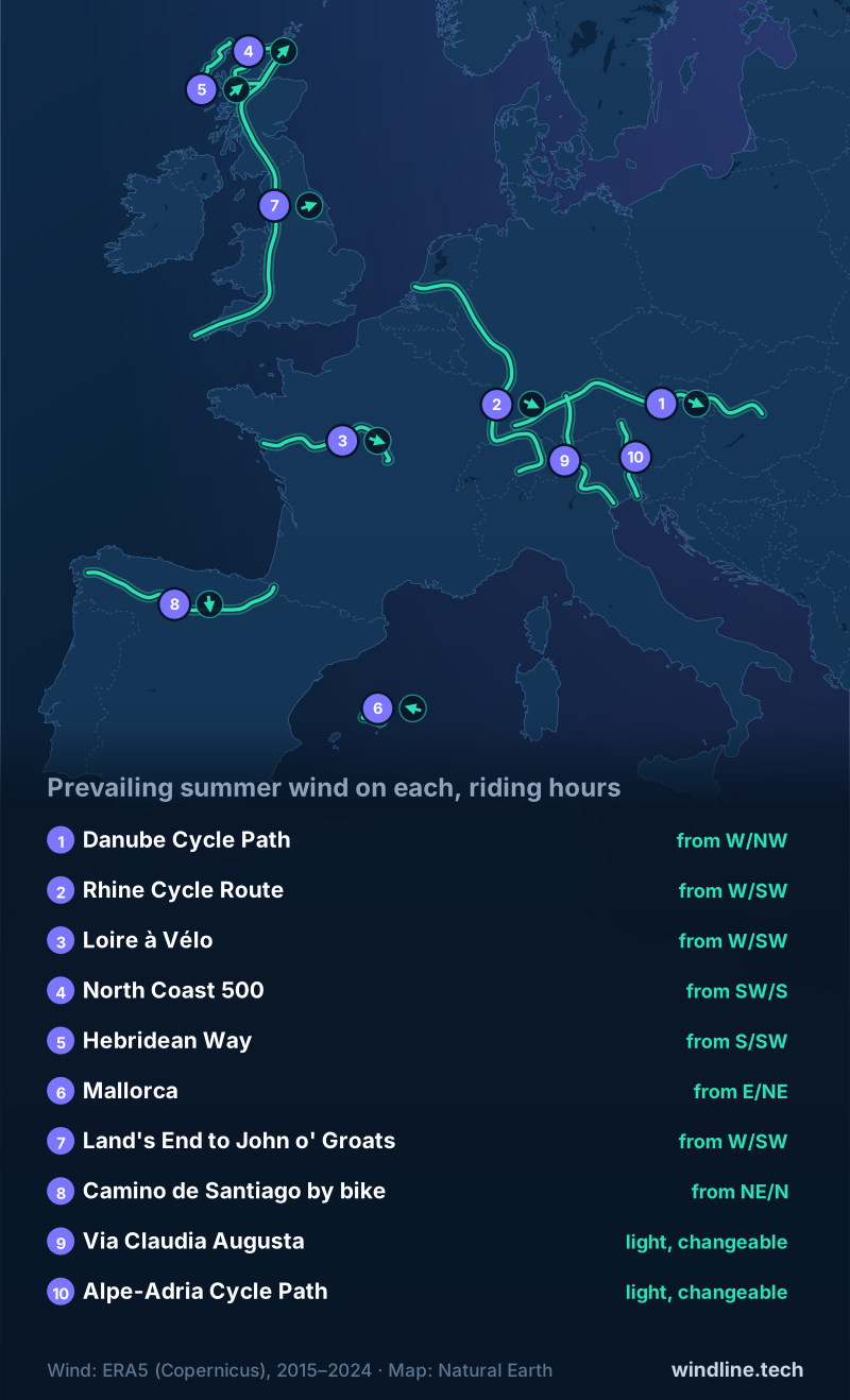
- Prevailing wind is a starting point; check the forecast for your own dates.
Definitions
- EuroVelo
- The network of long-distance cycle routes across Europe run by the European Cyclists' Federation, such as EuroVelo 6 along the Danube.
- Prevailing wind
- The wind direction that blows most often at a place over many years; it tells you what to expect, not what you'll get.
- Riding hours
- In our wind figures, the hours from 08:00 to 17:00 local time, when touring riders are usually on the road.
How did we choose the best cycling routes in Europe?
Two tests: riders search for them, and an official body looks after them. We didn't count or estimate riders. This list sits under our guide to the world's great cycling routes.
- Search interest. The routes that keep appearing in today's top results for "best cycling routes in Europe" and close variants.
- A documented route. Every length, day count and season below comes from the route's managing or tourism body, checked on 10 October 2026.
How do the ten routes compare?
Land's End to John o' Groats and the rivers are the long ones; the islands and the Alps fit into about a week.
| Route | Country | Length, km (miles) | Usual days | Surface | Best months | Prevailing wind (May–Sep, riding hours) |
|---|---|---|---|---|---|---|
| Danube (EuroVelo 6), Donaueschingen–Budapest | Germany to Hungary | 1,230 (764) | 22–26* | Flat paths and roads | May–Oct | W or NW, 9 km/h (6 mph) |
| Rhine (EuroVelo 15), Andermatt–North Sea | Switzerland to Netherlands | 1,233–1,450 (766–901) | 15–21* | Paths and roads | May–Sep | W or SW, 10 km/h (6 mph) |
| Loire à Vélo | France | 630 (391) | 7+ | Quiet roads, paths | Apr–Oct | W or SW, 13 km/h (8 mph) |
| North Coast 500 | Scotland, UK | 830 (516) | 8 | Roads, single-track | Late spring, early autumn | SW or S, 20 km/h (12 mph) |
| Hebridean Way | Scotland, UK | 297 (185) | 7 | Roads, 2 ferries | Apr–Sep | S or SW, 25 km/h (16 mph) |
| Mallorca loops | Spain | 70–120 (43–75) a loop | Day rides | Roads | Jan–May, Sep–Nov | E or NE, 12 km/h (7 mph) |
| Land's End to John o' Groats | UK | 1,407–1,610 (874–1,000) | 10–16 | Roads | May–Jun | W or SW, 21 km/h (13 mph) |
| Camino Francés | Spain | 800 (497) | 10–13* | Roads, tracks | Spring, Sep–Oct | NE or N, 11 km/h (7 mph) |
| Via Claudia Augusta | Germany, Austria, Italy | 700 (435) | 10–14 | Mostly tarmac | After early May | Light, changeable, 8 km/h (5 mph) |
| Alpe-Adria | Austria, Italy | 410 (255) | 6–8 | Mostly paths, quiet roads | Late Apr–mid-Oct | Light, changeable, 8 km/h (5 mph) |
* Our estimate (see method). Wind: Windline's own analysis of ERA5 data, 2015–2024, 08:00–17:00 local time.
Want this for your own route? Windline shows the wind for every stretch, timed to your pace. Free. Make a free ride page →
Which river routes suit a first tour?
All three follow a valley, so the gradient is gentle and the towns are close together.
Danube Cycle Path (EuroVelo 6)
Deutsche Donau splits Donaueschingen to Passau, over 600 km (373 miles), into 12 stages. EuroVelo calls Passau to Vienna "one of the most famous stages of the route". See our Danube guide and which way to ride it.
Wind: West or north-west, averaging 9 km/h (6 mph).
Rhine Cycle Route (EuroVelo 15)
EuroVelo calls it the most popular route in its network; 1,287 km (800 miles) is certified. EuroVelo advises the first stretch, Andermatt to Breil/Brigels, for experienced cyclists only. See our Rhine guide.
Wind: West or south-west, averaging 10 km/h (6 mph).
Loire à Vélo
France Vélo Tourisme gives 630 km (391 miles) from Nevers to the Atlantic, plus 270 km (168 miles) of loops, signposted both ways. See our Loire guide.
Wind: West or south-west, averaging 13 km/h (8 mph).
Which coast and island routes are worth the trip?
On these road routes, ferries, narrow lanes and the weather set your pace.
North Coast 500
The official site gives 830 km (516 miles) from Inverness and back. Its cycling itinerary, "aimed at the serious cyclist", takes eight days at about 105 km (65 miles) a day, much of it single-track. See our North Coast 500 guide.
Wind: South-west or south, averaging 20 km/h (12 mph).
Hebridean Way
Visit Outer Hebrides gives 297 km (185 miles) across 10 islands, 6 causeways and 2 ferries, signposted as National Cycle Network Route 780. Its schedule fits a week. See our Hebridean Way guide.
Wind: South or south-west, averaging 25 km/h (16 mph).
Mallorca
A base, not a line. The Balearic tourism board counts 468 km (291 miles) of signposted routes plus loops of 70–120 km (43–75 miles). See Mallorca cycling weather.
Wind: East or north-east, averaging 12 km/h (7 mph).
Which long classics take two weeks?
Two end-to-end journeys, each with an obvious finish line.
Land's End to John o' Groats
There's no single signed route. Cycling UK gives 1,407 km (874 miles) by the traditional roads, or a little over 1,610 km (1,000 miles) on its quieter routes, and calls May and June probably the best months. Read LEJOG or JOGLE for direction.
Wind: West or south-west, averaging 21 km/h (13 mph).
Camino de Santiago (Camino Francés)
Spain's tourism board gives about 800 km (497 miles) from Roncesvalles, waymarked with yellow arrows. For the Compostela, cyclists must ride at least the last 200 km (124 miles). See our Camino by bike guide.
Wind: North-east or north, averaging 11 km/h (7 mph).
Which Alpine routes cross the mountains by bike?
Both use valleys, shuttles or trains to tame the climbs.
Via Claudia Augusta
About 700 km (435 miles) from Donauwörth over the Fernpass and Reschenpass to Altino, near Venice. The route body allows 10 to 14 days and suggests riding north to south, as some signs only point south.
Wind: Light and changeable (calm 31% of riding hours), averaging 8 km/h (5 mph).
Alpe-Adria Cycle Path
Austria's tourism board gives 410 km (255 miles) from Salzburg to Grado. A rail shuttle carries you through the Tauern tunnel; the line closes from 8 February to 9 July 2027, with a replacement for cyclists.
Wind: Light and changeable (calm 34% of riding hours), averaging 8 km/h (5 mph).
Which one should you pick?
- First tour: the Loire, or the Danube from Passau to Vienna.
- One week: the Hebridean Way or the Alpe-Adria.
- Spring or autumn: Mallorca or the Camino.
- A big challenge: LEJOG or the North Coast 500.
Like the rivers? Try the Great Allegheny Passage in the US or New Zealand's Otago Central Rail Trail, from our North America and New Zealand lists.
How do you plan any of these routes?
Fix your nights first: check wild camping rules, then plan the stages. Prevailing wind isn't guaranteed, so check the forecast for your dates.
Frequently asked questions
What is EuroVelo, and does it mean a route is fully signposted?
EuroVelo is the European Cyclists' Federation's network of long-distance routes. Not every section is finished: EuroVelo labels each one certified, developed with or without signs, or partly developed. Check its route map for the sections you'll ride, and carry a map or navigation app where signs are missing.
Which European cycle route is easiest for a first tour?
The Loire à Vélo or the Danube from Passau to Vienna. Both follow a river and are signposted, and EuroVelo describes Passau to Vienna as comfortable flat roads. The Loire à Vélo team suggests first-timers ride 30–50 km (19–31 miles) a day. See [how far you can cycle in a day](/blog/how-far-can-you-cycle-in-a-day/).
Can you cycle these routes in winter?
Some of them. Mallorca's tourism board promotes cycling from January to May. The North Coast 500's official site says the route works all year, though some services close. The Loire can flood in winter and early spring, and EuroVelo suggests waiting until May to ride the Rhine between Andermatt and Chur.
How much climbing is there on the Alpine routes?
Less than the mountains suggest. The official Alpe-Adria site gives 5,410 m (17,750 ft) of climbing from Salzburg to Grado, spread over a week. On the Via Claudia Augusta, the Reschenpass rises about 500 m (1,640 ft) above Pfunds, and shuttles can carry you up the passes.
Do you need a special bike for European cycle routes?
No, but match the tyres to the surface. The Loire à Vélo's official FAQ says its surface isn't only asphalt and suggests a hybrid rather than narrow racing tyres. The Via Claudia Augusta is almost completely tarmac, while the Camino mixes roads with gravel pilgrim paths.
Get the wind for your ride.
Upload a GPX, add your start time and pace, and see the headwind, gusts, rain and heat for every stretch of the route, timed to when you’ll be there. Free for riders.
Make a free ride page →Sources and method
- EuroVelo (European Cyclists' Federation) (2026). EuroVelo 6: Atlantic – Black Sea
- EuroVelo (European Cyclists' Federation) (2026). EuroVelo 6: from Passau to Vienna
- Deutsche Donau (2026). Donauradweg 2026 (route brochure)
- Oberösterreich Tourismus (2026). Danube cycle path on the north bank, Passau to Bratislava
- EuroVelo (European Cyclists' Federation) (2026). EuroVelo 15: Rhine Cycle Route
- EuroVelo (European Cyclists' Federation) (2026). The complete guide to cycling EuroVelo 15: what you need to know before you go
- France Vélo Tourisme (2026). La Loire à Vélo
- La Loire à Vélo (2026). FAQ
- North Coast 500 (2026). North Coast 500 travel guide
- North Coast 500 (2026). Planning your North Coast 500 adventure
- Visit Outer Hebrides (2026). Cycling the Hebridean Way (route leaflet)
- Illes Balears tourism (2026). The Balearic Islands, Europe's cycle tourism paradise
- Cycling UK (2018). End to End introduction and advice (route pack)
- Pilgrim's Office, Santiago de Compostela (2026). The Compostela
- Spain Tourism (Turespaña) (2026). The French Way, Camino de Santiago
- Via Claudia Augusta (2026). Cycling the Via Claudia Augusta
- Via Claudia Augusta (2026). Frequently asked questions
- Austrian National Tourist Office (2026). Alpe Adria Radweg
- Alpe Adria Radweg (2026). Tauernschleuse Böckstein–Mallnitz
- Alpe Adria Radweg (2026). Tauern Tunnel closure spring 2027
- Copernicus Climate Change Service (ECMWF) (2026). ERA5 hourly time-series data on single levels from 1940 to present
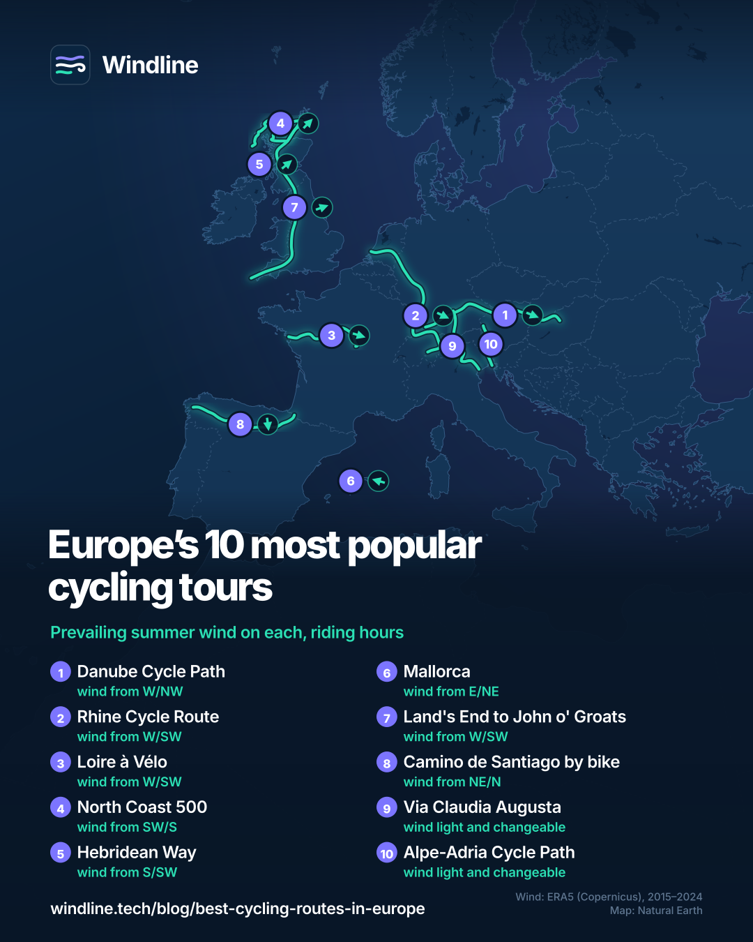
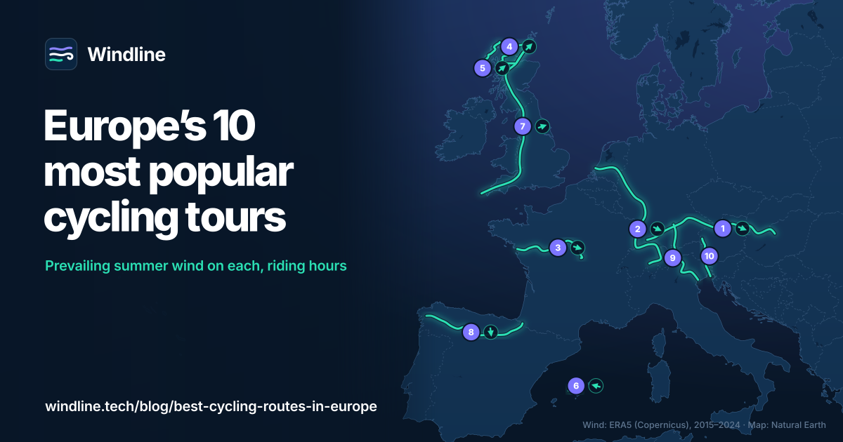
How we chose: we searched "best cycling routes in Europe" and close variants on 10 October 2026 and listed the routes that recur in the top results, then kept routes with a managing body or official tourism site that publishes their length and signage. We grouped them as rivers, coasts and islands, long classics and the Alps, and did not estimate rider numbers. Every length, day count, signage note and season comes from the bodies in the sources, checked on 10 October 2026. Where bodies disagree we give both figures. The Danube length is our sum of official section figures: over 600 km Donaueschingen to Passau (Deutsche Donau), about 320 km Passau to Vienna and 310 km Vienna to Budapest (the section lengths EuroVelo lists), about 1,230 km in all. Days marked * are our estimates where no body gives a whole-route figure: the Danube from Deutsche Donau's 12 stages to Passau and the 10 Austrian stages counted by Donau Niederösterreich (22 in all), plus up to about 4 days from the Austrian border to Budapest; the Rhine and the Camino at 60–80 km (37–50 miles) a day, so 1,233 km takes 15–21 days and 800 km takes 10–13. The North Coast 500's eight days come from its official cycling itinerary of about 65 miles (105 km) a day. Prevailing wind: Windline's own analysis of hourly 10 m (33 ft) wind from ERA5 reanalysis (Copernicus Climate Change Service, ECMWF), 1 January 2015 to 31 December 2024, downloaded from the Copernicus Climate Data Store, for riding hours 08:00 to 17:00 local time from May to September, at three sample points along each route (near the start, middle and end; for the North Coast 500 loop and Mallorca, spread around it), using the nearest 0.25° grid cell. The two directions given are the commonest of eight compass sectors, with their combined share of riding hours; hours under 5 km/h (3 mph) count as calm. Where the two commonest directions are not neighbours and the hours barely agree on a direction (as with the valley winds of the Alps), we call the wind light and changeable and draw no arrow. These are averages of past seasons, not forecasts. Credit: contains modified Copernicus Climate Change Service information (ERA5, 2015–2024); neither the European Commission nor ECMWF is responsible for any use of this information. The route lines on the overview map join town centres in riding order; they are approximate and not official routes. Conversions use 1 mile = 1.609 km and 1 ft = 0.3048 m, rounded.
About the author
Wes Thomson, Founder, Windline. Wes Thomson builds Windline, live wind and weather forecasts timed to when riders reach each stretch of road. He built it for his own 2,093 km tour from Pont Drift to Cape Town, and writes these guides with the same focus: what the wind will do to your ride, and how to plan around it.