Land's End to John o' Groats by bike: the LEJOG route
Choose your line from Land's End to John o' Groats, size your days, read the weather by month and book the trains at both ends.
The short answer
The LEJOG route runs from Land's End in Cornwall to John o' Groats in Caithness, Scotland. It's 1,407 km (874 miles) by the traditional roads, or about 1,600 to 1,913 km (1,000 to 1,189 miles) on quieter cycle routes. Most riders allow about two weeks, and Cycling UK calls May and June probably the best months.
Key takeaways
- There's no single signed line; choose main roads, quieter touring routes or the National Cycle Network.
- Two weeks means about 114 km (71 miles) a day; three weeks, about 77 km (48 miles).
- Cornwall and Devon hold the steepest climbing, so plan shorter days there.
- Bike reservations are compulsory on the trains from Wick and Thurso; book early.
Definitions
- LEJOG
- Land's End to John o' Groats, the end-to-end ride along Great Britain; ridden southbound it's called JOGLE.
- National Cycle Network
- The UK's network of signed cycle routes on greenways, paths and quiet roads, looked after by Walk Wheel Cycle Trust (formerly Sustrans).
What is the LEJOG route?
The LEJOG route is the end-to-end ride along Great Britain, from Land's End in Cornwall to John o' Groats in Caithness, Scotland. There's no single signed line: you pick main roads, quieter touring routes or the National Cycle Network. It's one of the best cycling routes in Europe and part of our guide to the world's great cycling routes.
| At a glance | LEJOG |
|---|---|
| Length | 1,407 km (874 miles) by the traditional roads; 1,600–1,913 km (1,000–1,189 miles) on quieter routes |
| Countries | England and Scotland (some lines cross Wales near the Severn) |
| Usual days | 10–14 by road; 14–16 on Cycling UK's scenic routes |
| Surface | Roads and lanes; the National Cycle Network line adds greenways and cycle paths |
| Signage | None end to end; you follow a route pack, guidebook or GPX |
| Best months | May and June (Cycling UK) |
Which route options and stages do people ride?
Your choice of line sets the distance more than anything else.
- Main roads. Cycling UK's pack includes a fast route on busy A roads. The traditional road distance takes most cyclists 10 to 14 days.
- Quieter touring routes. Cycling UK's B&B and YHA routes run a little over 1,610 km (1,000 miles) over 14 to 16 days. Cicerone's guidebook covers about 1,600 km (1,000 miles) in 14 stages of 96–147 km (60–92 miles), with schedules from 10 to 18 days.
- The National Cycle Network. Walk Wheel Cycle Trust (formerly Sustrans) gives 1,913 km (1,189 miles) of greenways, cycle paths and country roads, on the network for over three-quarters of its length.
Cycling UK puts two weeks at about 114 km (71 miles) a day and three weeks at about 77 km (48 miles). It calls the south-west "by far the worst section" for hills and suggests shorter days there and in central Scotland. Further north, the A6 between Kendal and Penrith climbs over Shap Summit, above 410 m (1,350 ft). See how far you can cycle in a day to size your stages.
Want this for your own route? Windline shows the wind for every stretch, timed to your pace. Free. Make a free ride page →
What's the weather like through the year?
The wind eases and the days warm from spring to August, then wind and rain build again from September.
Weather across the year on the Land's End to John o' Groats, 2015–2024
| Month | Wind from | Average wind, km/h (mph) | Gusty days | Start → high, °C (°F) | Wet days |
|---|---|---|---|---|---|
| Jan | W, SW | 29 (18) | 52% | 7° (44°) → 8° (46°) | 62% |
| Feb | W, SW | 30 (19) | 53% | 6° (44°) → 8° (46°) | 62% |
| Mar | W, SW | 26 (16) | 42% | 7° (44°) → 8° (47°) | 54% |
| Apr | ~Changeable | 23 (14) | 26% | 8° (46°) → 10° (49°) | 41% |
| May | ~Changeable | 21 (13) | 17% | 10° (51°) → 12° (54°) | 40% |
| Jun | W, SW | 20 (13) | 15% | 13° (55°) → 15° (58°) | 44% |
| Jul | W, NW | 20 (12) | 13% | 14° (58°) → 16° (61°) | 48% |
| Aug | W, SW | 21 (13) | 16% | 15° (58°) → 16° (61°) | 51% |
| Sep | ~Changeable | 23 (14) | 29% | 13° (56°) → 15° (59°) | 52% |
| Oct | S, SW | 26 (16) | 39% | 11° (53°) → 13° (55°) | 59% |
| Nov | W, SW | 28 (17) | 47% | 9° (48°) → 10° (50°) | 68% |
| Dec | SW, W | 29 (18) | 51% | 8° (46°) → 9° (48°) | 67% |
In May and June, the best months, gusty days fall to 17% and 15%, against 52% in January. The wind averages 21 km/h (13 mph) in May, from no steady direction, and 20 km/h (13 mph) in June. July and August are warmest, reaching 16°C (61°F), but wet days rise to 48% and 51%. From October, gusty days pass 39% and wet days 59%.
Which way should you ride it?
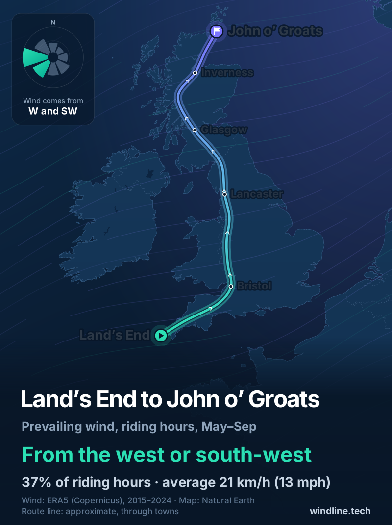
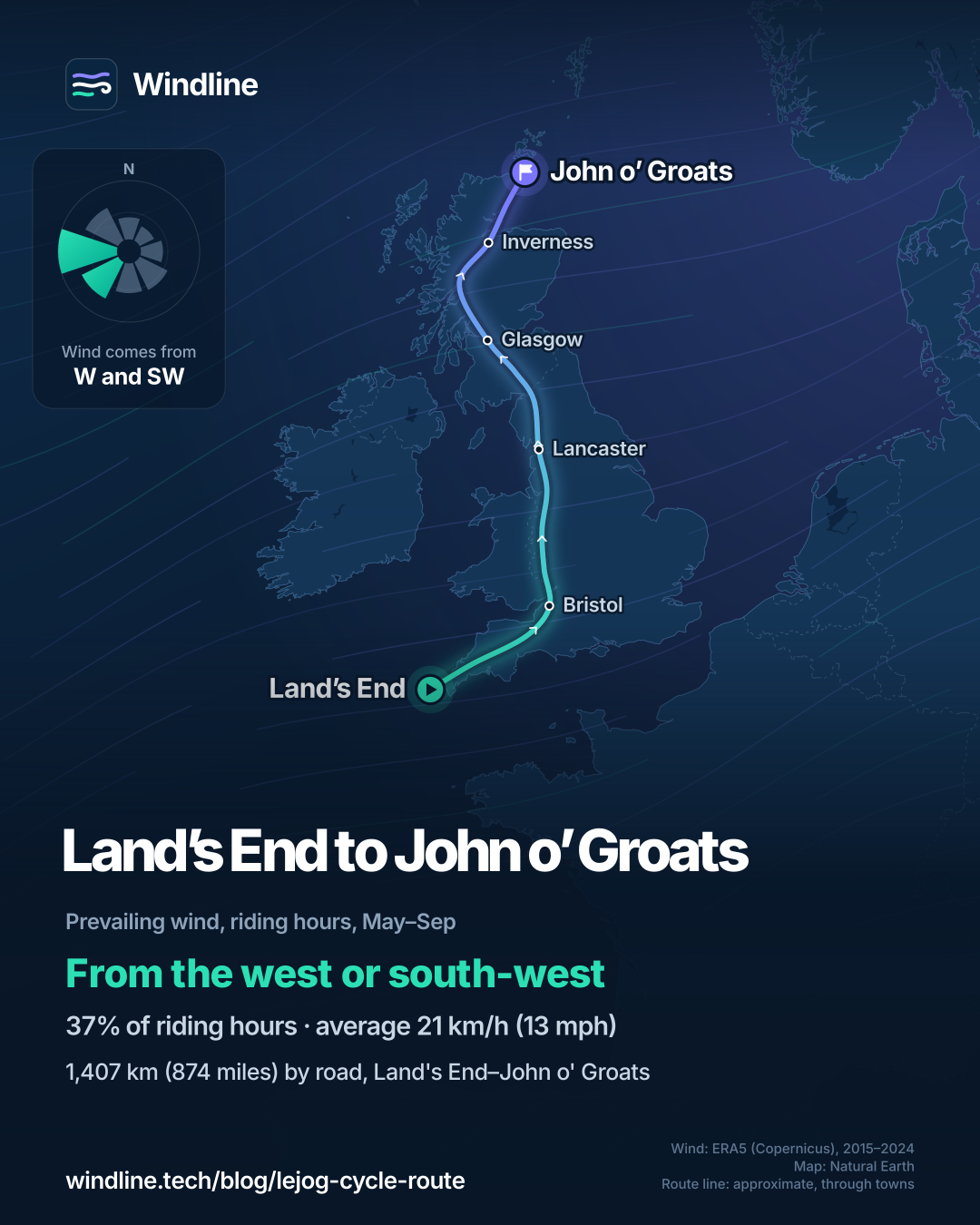
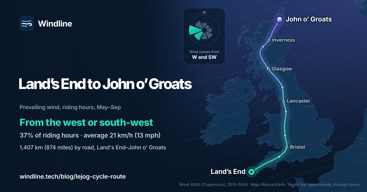
Northbound, if the wind decides it. From May to September, riding-hour wind came most often from the west or south-west (37% of hours) and averaged 21 km/h (13 mph), which tends to help a rider heading north. That's an average of past seasons, not a forecast. Our LEJOG or JOGLE guide has the full direction analysis.
Cycling UK's and Cicerone's routes are written south to north; Cicerone also gives GPX tracks for riding south.
How do you get to Land's End and home from John o' Groats?
By train at both ends. Book your bike when you book yourself.
- The start. Penzance is the nearest station, about 16 km (10 miles) from Land's End. GWR makes a bike reservation mandatory on the Night Riviera Sleeper. Its other trains carry at least two full-size bikes, but unreserved bikes can't board trains arriving at London Paddington from 07:30 to 09:30 or leaving from 16:00 to 19:00.
- The finish. Wick is about 27 km (17 miles) from John o' Groats and Thurso about 32 km (20 miles). ScotRail makes cycle reservations compulsory on its Inverness, Wick and Thurso trains.
Then plan the rest of the tour. Want a bigger end-to-end? The TransAmerica Trail crosses the US over 6,767 km (4,205 miles).
Frequently asked questions
Is the LEJOG route signposted?
Not from end to end. Cycling UK supplies written directions and GPX files, and warns that new roads get built and signposts can change. Walk Wheel Cycle Trust's line follows numbered National Cycle Network routes, such as Route 3 in Cornwall and Route 7 in Scotland, but you still need the full route on a device or map. Our guide to [GPX files for cycling](/blog/gpx-files-for-cycling/) explains how.
What bike do you need for LEJOG?
A comfortable touring bike, hybrid or road bike with low gears is enough. Walk Wheel Cycle Trust says all-terrain, touring and hybrid bikes will manage its route of paths and country roads fine. Cycling UK's pack calls a triple chainset highly desirable, suggests at least a rear mudguard, and says to train on the bike you'll ride.
Where do you stay on LEJOG?
Hostels, B&Bs, hotels or campsites. Cycling UK's pack has routes built around youth hostels and B&Bs, and warns hostels can be so busy in school term time that late July or August is the only choice. Camping costs time each day. In Scotland, access rights let you [wild camp](/blog/wild-camping-rules-by-country/) responsibly; in England, you mostly need the landowner's consent.
Get the wind for your ride.
Upload a GPX, add your start time and pace, and see the headwind, gusts, rain and heat for every stretch of the route, timed to when you’ll be there. Free for riders.
Make a free ride page →Sources and method
- Cycling UK (2018). End to End introduction and advice (route pack)
- Cycling UK (2026). Cycling Land's End to John o' Groats? Get the End to End pack
- Walk Wheel Cycle Trust (2026). Land's End to John o'Groats (LEJOG) on the National Cycle Network
- Walk Wheel Cycle Trust (2025). Why we've changed our name to Walk Wheel Cycle Trust
- Cicerone Press (2021). Cycling Land's End to John o' Groats (Richard Barrett, 3rd edition)
- Great Western Railway (2026). Bringing your bike
- ScotRail (2026). Bikes on trains
- Wikipedia (2026). A6 road (England)
- Copernicus Climate Change Service (ECMWF) (2026). ERA5 hourly time-series data on single levels from 1940 to present
Route lengths, days, best months, hills, accommodation and travel come from the official sources listed, opened on 10 October 2026: Cycling UK's End to End pack (ride content last updated in summer 2016) and its current web page, Walk Wheel Cycle Trust's route page, Cicerone's guidebook page, and the GWR and ScotRail cycle pages. Daily distances are Cycling UK's 71 and 48 miles a day, converted at 1 mile = 1.609 km. The weather table and every weather figure in the text are Windline's own analysis of Copernicus ERA5 (2015–2024) via the Copernicus Climate Data Store, for riding hours 08:00–17:00 local time, pooled over three sample points along the route (Land's End, Lancaster and John o' Groats). A gusty day has a riding-hour gust of 50 km/h (31 mph) or more; a wet day has 1 mm or more of rain; start is the 08:00 temperature and high is the warmest riding hour. Months with no steady wind direction are shown as changeable. The prevailing wind for May to September is the share of riding hours from the two most common directions, with hours under 5 km/h (3 mph) counted as calm. These are averages of past seasons, not a forecast. Contains modified Copernicus Climate Change Service information (ERA5, 2015–2024); neither the European Commission nor ECMWF is responsible for any use of this information.
About the author
Wes Thomson, Founder, Windline. Wes Thomson builds Windline, live wind and weather forecasts timed to when riders reach each stretch of road. He built it for his own 2,093 km tour from Pont Drift to Cape Town, and writes these guides with the same focus: what the wind will do to your ride, and how to plan around it.