The Rhine Cycle Route (EuroVelo 15): stages, weather and direction
Plan the Rhine from the Alps to the North Sea, with its stages, the weather month by month, the best direction and the way home.
The short answer
The Rhine Cycle Route, EuroVelo 15, follows the Rhine from Andermatt in the Swiss Alps to Hook of Holland on the North Sea. EuroVelo gives its length as 1,233 or 1,450 km (766 or 901 miles). Allow two to three weeks, ride it between May and September, and go downstream so the Alpine descent works for you.
Key takeaways
- EuroVelo gives 1,233 or 1,450 km; 1,287 km (800 miles) is certified to its quality standard.
- Wait until May for the Alpine start; Andermatt to Breil/Brigels suits experienced riders only.
- Summer winds average 10 km/h (6 mph), so the gradient, not the wind, decides your direction.
- Dutch trains take bikes on weekdays only off-peak, except in July and August.
Definitions
- EuroVelo certified
- A section inspected against the European Certification Standard for traffic, surface, signs and services; EuroVelo calls these the best options for beginners.
- Prevailing wind
- The wind direction that blows most often at a place over many years; it tells you what to expect, not what you'll get.
What is the Rhine Cycle Route?
The Rhine Cycle Route is EuroVelo 15, which EuroVelo calls the most popular route in its network. It follows the Rhine from Andermatt in the Swiss Alps to Hook of Holland on the North Sea. It's one of the ten tours on our list of the best cycling routes in Europe, part of our guide to the world's great cycling routes.
| Fact | Rhine Cycle Route |
|---|---|
| Length | 1,233–1,450 km (766–901 miles); EuroVelo gives both |
| Countries | Switzerland, Liechtenstein, Austria, Germany, France, the Netherlands |
| Usual days | 15–21 (our estimate, at 60–80 km (37–50 miles) a day) |
| Surface | Paths and roads; 1,287 km (800 miles) EuroVelo certified |
| Signage | EuroVelo 15 signs on developed sections; both directions in the Netherlands |
| Best months | May to September |
Which sections do people ride?
You don't have to ride it all. EuroVelo splits the route into seven stages, and each works on its own.
- Andermatt to Lake Constance. EuroVelo calls the climb to the Oberalp Pass, 2,044 m (6,706 ft), the hardest part of the route.
- Lake Constance to Basel, past the Rhine Falls, which EuroVelo calls Europe's largest waterfall.
- Basel to Bingen, through Alsace and the German vineyards, crossing between France and Germany by bridge or ferry.
- Bingen to Cologne, through the Upper Middle Rhine Valley, a UNESCO World Heritage Site.
- Cologne to the North Sea: the Ruhr, the Lower Rhine, then Dutch rivers, ferries and Rotterdam.
Want this for your own route? Windline shows the wind for every stretch, timed to your pace. Free. Make a free ride page →
What's the weather like on the Rhine through the year?
Summer is the calmest and least gusty time, but rain is common all year.
Weather across the year on the Rhine Cycle Route (EuroVelo 15), 2015–2024
| Month | Wind from | Average wind, km/h (mph) | Gusty days | Start → high, °C (°F) | Wet days |
|---|---|---|---|---|---|
| Jan | SW, S | 13 (8) | 27% | 0° (31°) → 3° (37°) | 51% |
| Feb | SW, S | 13 (8) | 27% | 0° (32°) → 5° (41°) | 45% |
| Mar | ~Changeable | 13 (8) | 24% | 2° (35°) → 8° (46°) | 46% |
| Apr | ~Changeable | 11 (7) | 17% | 4° (40°) → 11° (51°) | 42% |
| May | N, NE | 11 (7) | 11% | 9° (48°) → 15° (58°) | 51% |
| Jun | ~Changeable | 10 (6) | 9% | 14° (57°) → 20° (68°) | 49% |
| Jul | W, N | 10 (6) | 11% | 15° (60°) → 22° (71°) | 51% |
| Aug | W, SW | 10 (6) | 8% | 15° (58°) → 22° (71°) | 48% |
| Sep | SW, W | 10 (6) | 13% | 11° (51°) → 18° (64°) | 45% |
| Oct | SW, S | 11 (7) | 19% | 8° (46°) → 13° (55°) | 46% |
| Nov | S, SW | 12 (7) | 21% | 3° (38°) → 7° (44°) | 50% |
| Dec | SW, S | 13 (8) | 23% | 1° (34°) → 4° (39°) | 50% |
From May to September, the riding-hour wind averages 10–11 km/h (6–7 mph), and 8–13% of days are gusty, against 27% in January and February. Rain falls on 42–51% of days in every month. July and August reach 22°C (71°F), but the table includes Andermatt, at 1,437 m (4,715 ft), so the lowlands usually run warmer.
Which way should you ride the Rhine Cycle Route?
Downstream, from Andermatt to the North Sea. The gradient decides it; the summer wind is too light to argue.
SwitzerlandMobility gives Andermatt to Basel 3,400 m (11,150 ft) of climbing and 4,600 m (15,090 ft) of descent, so riding upstream adds about 1,200 m (3,940 ft).
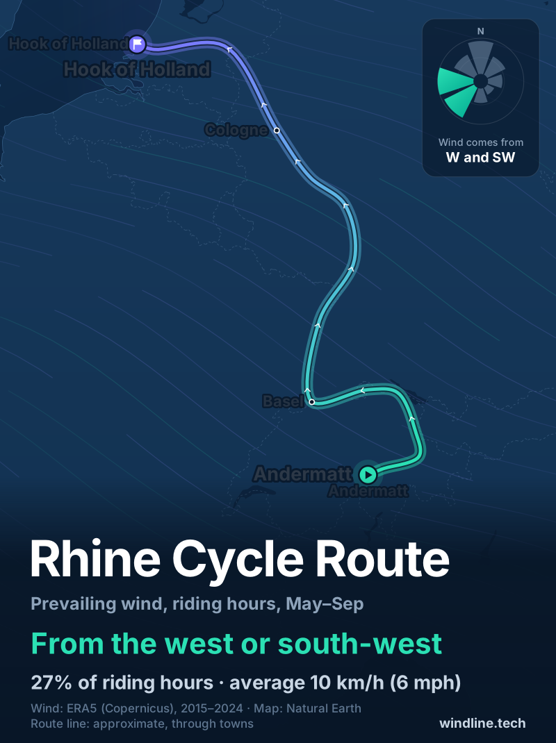
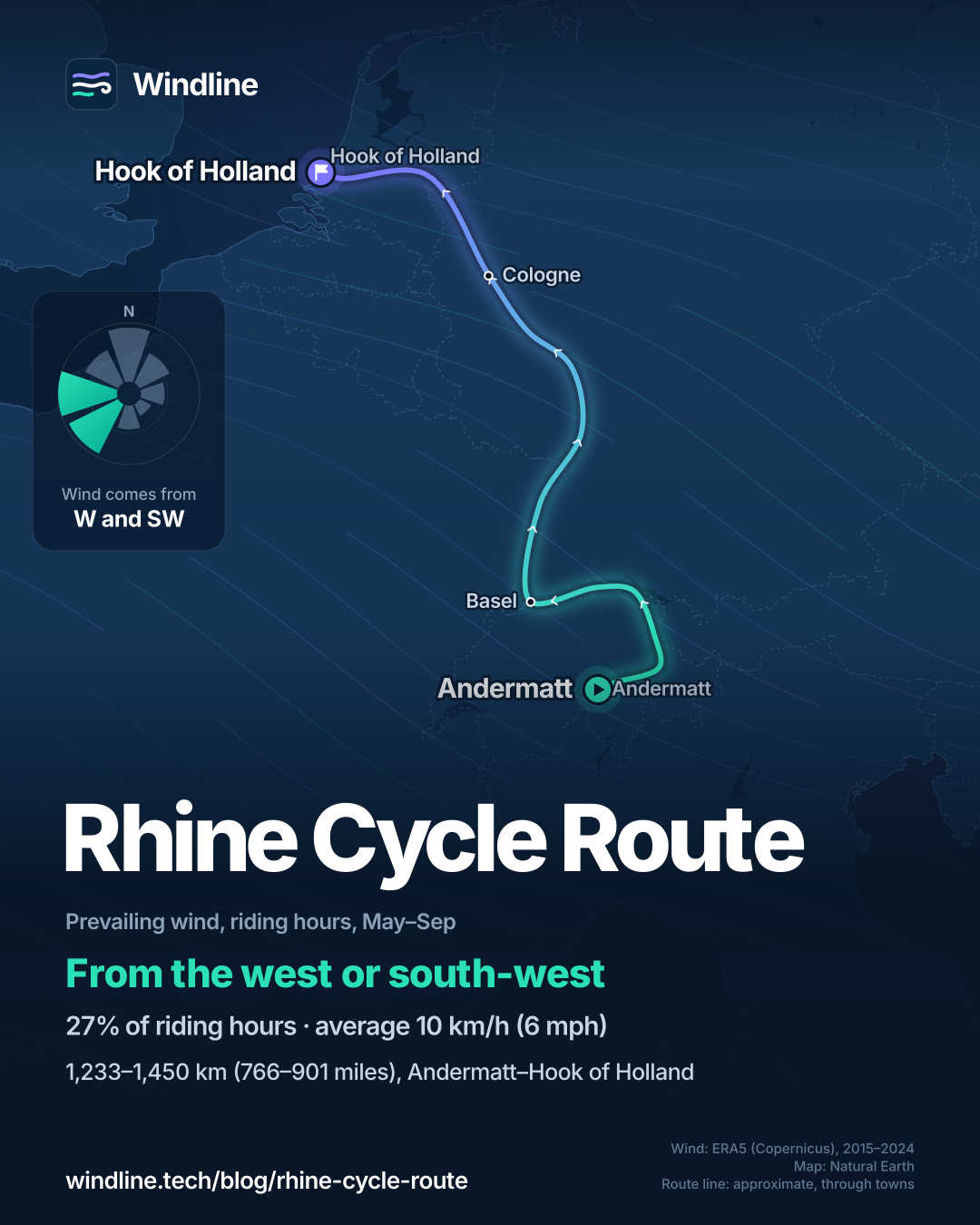
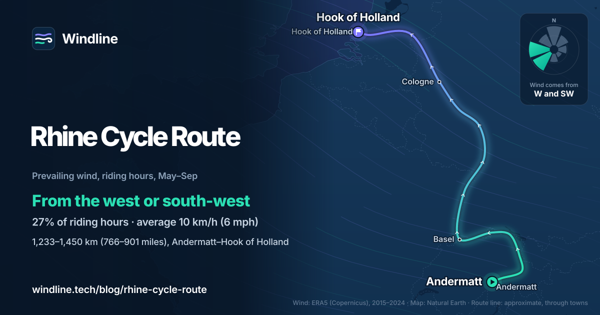
From May to September, our data shows the wind most often from the west or south-west (27% of riding hours), averaging 10 km/h (6 mph), and calm 30% of the time. Heading north through Germany, that's mostly side-on; on the westward run across the Netherlands it's in your face. These are averages of past seasons, not a forecast. Alpine valleys make their own winds, while the Dutch delta is open to the sea: see whether there's always a headwind in the Netherlands.
Liked the Rhine? The Danube is a similar river ride, with summer winds mostly from the west or north-west, and Missouri's car-free Katy Trail is on our North America list.
How do you get to the start and home again?
By train, mostly. EuroVelo says most trains along the route take bikes, usually for a fee.
- Switzerland. Some trains need a bike reservation. To skip the Oberalp climb, take the train from Andermatt.
- Germany in 2026. Replacement buses take no bikes during works on the Hochrhein line (Rheinfelden–Erzingen) and the right-bank line (Wiesbaden–Troisdorf), so check before you travel.
- The Netherlands. On weekdays, NS takes bikes only from 09:00 to 16:00 and after 18:30, with a Fietskaart Dal. Weekends, public holidays (not King's Day) and July and August are unrestricted.
- To Britain. Stena Line sails Hook of Holland to Harwich, about 6 hours 30 minutes, and takes bicycles.
For nights out, check the wild camping rules, then plan your stages.
Frequently asked questions
Is the Rhine Cycle Route suitable for beginners?
Mostly, yes. EuroVelo says 73% of the certified route suits all types of cyclists, including families, and calls its elevation profile almost negligible. The exception is the start: it advises the stretch from Andermatt to Breil/Brigels for experienced cyclists only, because of mixed and high traffic. A first-timer can start at Chur or on Lake Constance instead.
How long does it take to cycle the Rhine from source to sea?
No official body gives a whole-route figure. At 60–80 km (37–50 miles) a day, 1,233 km takes 15–21 days, and EuroVelo's longer 1,450 km figure takes 18–24. SwitzerlandMobility splits the Swiss part, Andermatt to Basel, into nine stages. See [how far you can cycle in a day](/blog/how-far-can-you-cycle-in-a-day/) to set your own pace.
Can you cycle both banks through the Rhine Gorge?
Not all the way. EuroVelo says the east bank still has gaps between Kestert and St. Goarshausen, so switch to the west bank there, which is fully rideable, or take a sightseeing boat for part of the way. Take care on both banks: in the narrow valley, some parts share the road with traffic in towns or run right beside it.
Get the wind for your ride.
Upload a GPX, add your start time and pace, and see the headwind, gusts, rain and heat for every stretch of the route, timed to when you’ll be there. Free for riders.
Make a free ride page →Sources and method
- EuroVelo (European Cyclists' Federation) (2026). EuroVelo 15: Rhine Cycle Route
- EuroVelo (European Cyclists' Federation) (2026). The complete guide to cycling EuroVelo 15: what you need to know before you go
- EuroVelo (European Cyclists' Federation) (2026). EuroVelo 15 in Switzerland
- EuroVelo (European Cyclists' Federation) (2026). EuroVelo 15 in the Netherlands
- EuroVelo (European Cyclists' Federation) (2026). From Bingen to Cologne, through the legendary landscapes of the Romantic Rhine
- EuroVelo (European Cyclists' Federation) (2023). Useful tips on combining cycling and public transport along EuroVelo 15
- SwitzerlandMobility (2026). Rhine Route (national route 2)
- NS (Dutch Railways) (2026). Bringing your bike on the train
- Stena Line (2026). Ferry to Hook of Holland and Harwich
- Stena Line (2026). Can I bring a bicycle onboard?
- Copernicus Climate Change Service (ECMWF) (2026). ERA5 hourly time-series data on single levels from 1940 to present
Route facts come from EuroVelo, SwitzerlandMobility, NS and Stena Line, read on 10 October 2026 (see the sources). EuroVelo publishes two lengths, 1,233 km and 1,450 km, so we give both. Usual days are our estimate, as no official body gives a whole-route figure: 1,233 km at 60–80 km (37–50 miles) a day is 15–21 days, and 1,450 km is 18–24. The extra climbing upstream is our arithmetic on SwitzerlandMobility's figures for Andermatt to Basel (4,600 m of descent minus 3,400 m of ascent). Best months are May to September, from EuroVelo's advice to wait until May for the Alpine start and its April-to-September window for Germany and the Netherlands. The weather table and the wind figures are Windline's own analysis of Copernicus ERA5 reanalysis, 1 January 2015 to 31 December 2024, downloaded from the Copernicus Climate Data Store (dataset reanalysis-era5-single-levels-timeseries), for riding hours 08:00 to 17:00 local time, at three sample points along the route (Andermatt, Karlsruhe and Hook of Holland), using the nearest 0.25° grid cell and pooling the hours and days of all three. Wind is 10 m (33 ft) wind; directions are where the wind blows from, the commonest two of eight compass sectors, and hours under 5 km/h (3 mph) count as calm; a month whose commonest directions barely agree is shown as changeable in direction. A gusty day has a riding-hour gust of 50 km/h (31 mph) or more; a wet day has 1 mm or more of rain; start is the 08:00 temperature and high is the warmest riding hour. The direction section uses the May to September figures. These are averages of past seasons, not forecasts. Contains modified Copernicus Climate Change Service information (ERA5, 2015–2024); neither the European Commission nor ECMWF is responsible for any use of this information. The map's route line joins town centres in riding order; it is approximate and not an official route map. Conversions use 1 mile = 1.609 km and 1 ft = 0.3048 m, rounded.
About the author
Wes Thomson, Founder, Windline. Wes Thomson builds Windline, live wind and weather forecasts timed to when riders reach each stretch of road. He built it for his own 2,093 km tour from Pont Drift to Cape Town, and writes these guides with the same focus: what the wind will do to your ride, and how to plan around it.