Loire à Vélo: cycling the Loire Valley from end to end
Plan the Loire à Vélo with its length, the sections people ride, the weather by month, which way to go and trains with bikes.
The short answer
The Loire à Vélo (Loire a Velo) is a signposted cycle route through France's Loire Valley, from Cuffy, near Nevers, to Saint-Brevin-les-Pins on the Atlantic. It runs 630 km (391 miles) end to end, or 900 km (559 miles) with its loops. It's gentle, signposted both ways and best ridden from April to October.
Key takeaways
- 630 km (391 miles) end to end, or 900 km (559 miles) with loops, signposted both ways.
- The official site suggests three week-long sections, split at Blois and Saumur.
- July and August were the driest and least gusty riding months from 2015 to 2024.
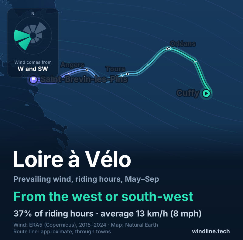
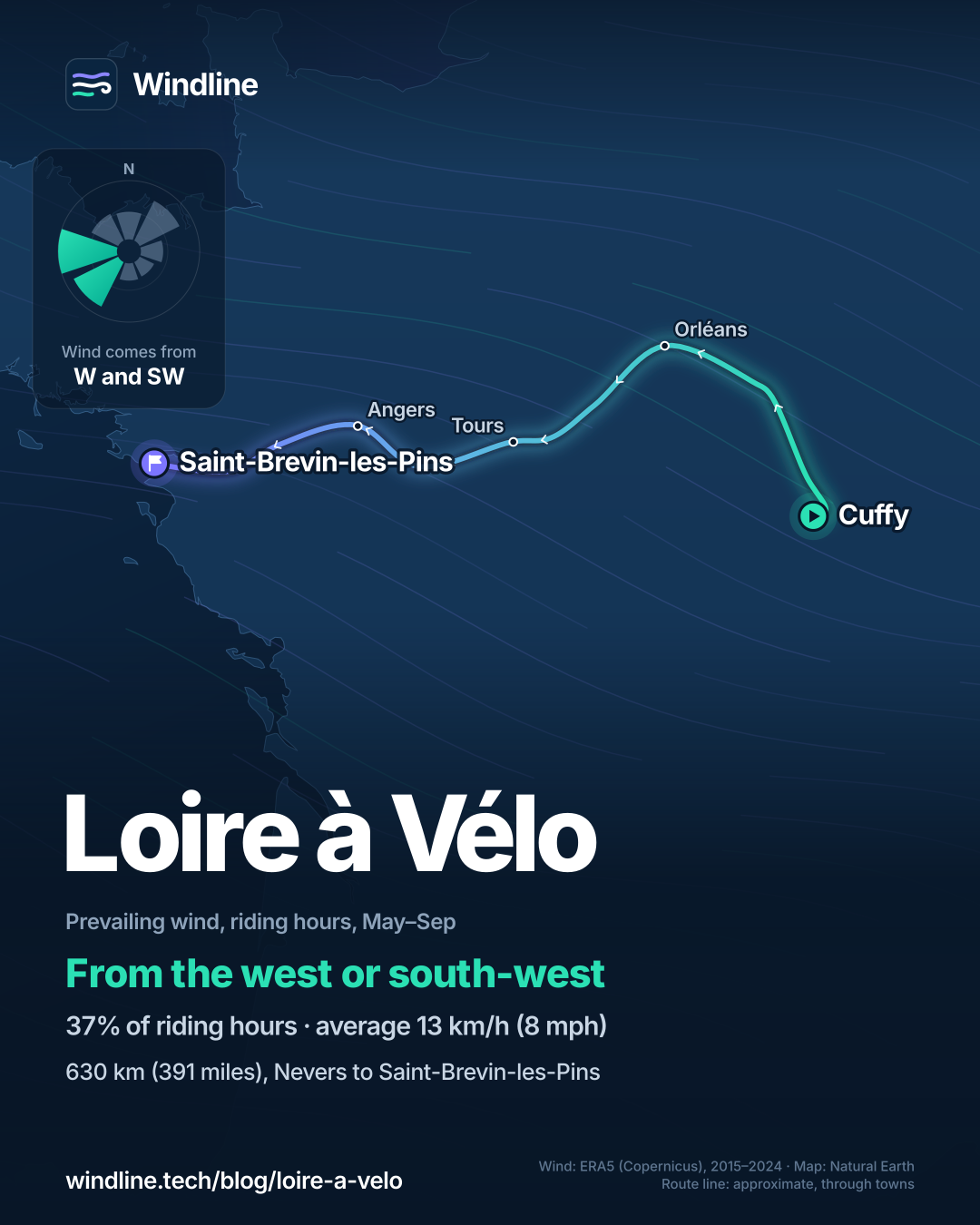
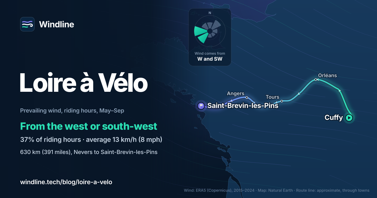
- West and south-west winds slightly favour riding inland, away from the sea.
Definitions
- EuroVelo 6
- The Atlantic to Black Sea cycle route in the European Cyclists' Federation's network; the Loire à Vélo is its westernmost section.
- Accueil Vélo
- France's national label for places that welcome touring cyclists, such as hotels, campsites and bike shops near a signposted route.
What is the Loire à Vélo?
La Loire à Vélo, often typed Loire a Velo, is France's best-known river cycle route: a signposted ride down the Loire Valley to the Atlantic. It's the westernmost section of EuroVelo 6 and one of the routes in our guide to the world's great cycling routes and the best cycling routes in Europe.
| The route at a glance | Official figures |
|---|---|
| Length | 630 km (391 miles) end to end; 900 km (559 miles) with 270 km (168 miles) of loops and variants |
| Start and finish | Cuffy, near Nevers, to Saint-Brevin-les-Pins on the Atlantic |
| Country | France: Centre-Val de Loire and Pays de la Loire |
| Usual days | A week or more; 37 official stages |
| Surface | 86% smooth, 5% rough; 62% on roads, 37% on cycle paths |
| Signage | Signposted throughout, in both directions |
| Best months | April to October |
The official FAQ says the surface isn't only asphalt and suggests a hybrid rather than a racing bike. For a gentle first tour on another continent, compare New Zealand's Otago Central Rail Trail.
Which sections do people ride?
Most riders pick one stretch rather than the whole river. The official site suggests three week-long sections:
- Cuffy to Blois, 277 km (172 miles): the eastern end, through Orléans.
- Blois to Saumur, 178 km (111 miles): through Amboise and Tours.
- Saumur to the Atlantic, 238 km (148 miles): Angers, Nantes and the estuary.
Each is planned over eight days. Shorter suggestions include Blois to Chambord and Tours to Chenonceau.
Running a tour? Give every rider one live forecast link for every stage. Set up your tour →
What's the weather like on the Loire through the year?
Mild and fairly breezy, with summer clearly the driest and calmest season.
Weather across the year on the Loire à Vélo, 2015–2024
| Month | Wind from | Average wind, km/h (mph) | Gusty days | Start → high, °C (°F) | Wet days |
|---|---|---|---|---|---|
| Jan | SW, W | 15 (10) | 20% | 4° (40°) → 8° (46°) | 43% |
| Feb | SW, W | 17 (10) | 24% | 5° (41°) → 10° (50°) | 41% |
| Mar | ~Changeable | 16 (10) | 23% | 6° (43°) → 13° (55°) | 44% |
| Apr | ~Changeable | 14 (9) | 11% | 8° (46°) → 16° (61°) | 34% |
| May | ~Changeable | 14 (9) | 12% | 12° (53°) → 19° (66°) | 40% |
| Jun | W, SW | 12 (8) | 5% | 16° (61°) → 23° (74°) | 37% |
| Jul | W, SW | 13 (8) | 4% | 17° (63°) → 25° (78°) | 25% |
| Aug | W, SW | 12 (7) | 4% | 17° (62°) → 25° (77°) | 26% |
| Sep | ~Changeable | 13 (8) | 11% | 13° (56°) → 22° (72°) | 31% |
| Oct | ~Changeable | 14 (9) | 13% | 11° (51°) → 17° (63°) | 38% |
| Nov | SW, W | 15 (9) | 18% | 7° (45°) → 12° (54°) | 43% |
| Dec | SW, W | 15 (10) | 19% | 6° (43°) → 9° (49°) | 42% |
In July, 25% of days were wet and 4% gusty, with highs of 25°C (78°F). April and October start cooler, at 8°C (46°F) and 11°C (51°F), and in both months the wind was changeable in direction. From November to March, 41–44% of days were wet and up to 24% gusty.
Which way should you ride the Loire à Vélo?
Slightly better inland, away from the Atlantic, but the difference is small. From May to September the wind blew from the west or south-west in 37% of riding hours, and from the north-east in 15%, averaging 13 km/h (8 mph).
Most of the route runs east to west, so riding towards the sea you'll meet a headwind more often than a tailwind. The first leg, from Cuffy to Orléans, heads north-west, where a west wind is more side-on. These are averages of past seasons, not a forecast.
At 13 km/h (8 mph), a headwind's cost is modest. The official FAQ says the route is just as easy both ways, so let trains and dates decide.
How do you get there and back with a bike?
By regional train. TER trains run from Paris to Nevers, and the official site says bikes travel free on TER trains in available spaces, outside rush hours.
- Weekend bookings: on some lines, including Paris to Nevers and Orléans to Saumur, a weekend bike space must be booked and costs €1 (as of October 2026).
- Loire à Vélo train: in 2026 it ran from 1 May to 30 August between Orléans and Nantes, reaching Le Croisic at weekends, with at least 50 bike spaces. Bike spaces cost €1 through Véloabord. Cargo bikes aren't allowed.
- Places to stay: France Vélo Tourisme counts more than 700 Accueil Vélo campsites, hotels and guest houses less than 5 km (3 miles) from the route.
The route continues east as EuroVelo 6, so you can link it to the Danube Cycle Path. Then plan your stages around trains and rooms.
Frequently asked questions
How far should you ride each day on the Loire à Vélo?
The route's official FAQ suggests beginners start with 30 to 40 km (19 to 25 miles) a day, which leaves time for châteaux, towns and wine stops. Fit riders who want to cover the full 630 km (391 miles) in about a week need roughly 90 km (56 miles) a day. Our guide to [how far you can cycle in a day](/blog/how-far-can-you-cycle-in-a-day/) helps you set your own figure.
Can someone carry your luggage between hotels on the Loire?
Yes. The route's official FAQ says specialised companies offer luggage transport, picking up your bags each morning and delivering them to your next night's accommodation. That lets you ride with a light bike and a day bag. Book it with your rooms, especially in July and August, and check which towns each company covers before you fix your stages.
Does the Loire flood the cycle route?
Sometimes. The official FAQ calls the Loire a wild river that sometimes overflows its banks, especially in winter and early spring. Riverside paths can then close or be diverted. If you ride between November and March, check the route's official website and local notices before each day, and keep a road alternative in mind for low-lying stretches.
One link for the whole tour.
Load every stage once. Each day gets a live Good, Fair or Tough rating, and your riders need no app and no account.
Set up your tour →Sources and method
- France Vélo Tourisme (2026). La Loire à Vélo
- La Loire à Vélo (2026). La Loire à Vélo (home page)
- La Loire à Vélo (2026). FAQ
- La Loire à Vélo (2026). Suggested itineraries
- La Loire à Vélo (2026). Loire à Vélo train
- La Loire à Vélo (2026). TER et cars régionaux
- France Vélo Tourisme (2026). FAQ: devenir Accueil Vélo
- Copernicus Climate Change Service (ECMWF) (2026). ERA5 hourly time-series data on single levels from 1940 to present
Route facts (length, start and finish, surface, signage, stages, best months, trains and accommodation) come from the official Loire à Vélo website and France Vélo Tourisme, opened on 10 October 2026. The best months shaded in the table, April to October, are the route's own guidance. Train rules and fares are as published for 2026 and can change each year. The 90 km (56 miles) a day in the FAQ is our arithmetic: 630 km over seven days. The weather table and the wind figures are Windline's own analysis of Copernicus ERA5 reanalysis, 2015–2024, downloaded from the Copernicus Climate Data Store, for riding hours 08:00 to 17:00 local time at three sample points along the route (Cuffy, Tours and Saint-Brevin-les-Pins). A gusty day has a riding-hour gust of 50 km/h (31 mph) or more; a wet day has 1 mm or more of rain; start is the 08:00 temperature and high is the warmest riding hour. The prevailing wind for May to September counts the commonest of eight compass sectors over all riding hours, with hours under 5 km/h (3 mph) counted as calm. Months where the wind barely settles on one direction are called changeable in direction. These are averages of past seasons, not forecasts. Contains modified Copernicus Climate Change Service information (ERA5, 2015–2024); neither the European Commission nor ECMWF is responsible for any use of this information. Conversions use 1 mile = 1.609 km, rounded.
About the author
Wes Thomson, Founder, Windline. Wes Thomson builds Windline, live wind and weather forecasts timed to when riders reach each stretch of road. He built it for his own 2,093 km tour from Pont Drift to Cape Town, and writes these guides with the same focus: what the wind will do to your ride, and how to plan around it.