The Danube Cycle Path: route, sections, weather and trains home
Choose your section of the Danube, see the weather for every month, and plan the trains there and back.
The short answer
The Danube Cycle Path follows the river for about 1,230 km (764 miles) from Donaueschingen in Germany through Austria and Slovakia to Budapest, mostly on flat riverside paths. The whole way takes roughly 22 to 26 riding days. Passau to Vienna, the busiest section, fits in a week. The official season is May to October.
Key takeaways
- Passau to Vienna, about 320 km (199 miles), is the busiest section and suits a first tour.
- Ferries and bridges let you switch banks; some crossings close in winter.
- In past summers, westerly winds blew more often than easterly ones, and they were light.
- Austrian long-distance trains need a bike ticket and a reservation, so book early.
What is the Danube Cycle Path?
The Danube Cycle Path runs beside the river from its source near Donaueschingen, Germany, to Budapest, about 1,230 km (764 miles) through four countries. It's part of EuroVelo 6, which carries on to the Black Sea, and one of our 10 most popular cycling tours in Europe. It sits in our guide to the world's great cycling routes.
| The route at a glance | |
|---|---|
| Length | About 1,230 km (764 miles), Donaueschingen to Budapest |
| Countries | Germany, Austria, Slovakia, Hungary |
| Usual days | 22–26 for the whole way (our estimate) |
| Surface | Flat; cycle paths through Austria, paths and roads elsewhere |
| Signage | Deutsche Donau signs in Germany, route R1 in Upper Austria; EuroVelo grades each section |
| Best months | May to October |
Which sections do people ride?
Passau to Vienna is the busiest section: Lower Austria's government reported 641,000 cyclists on it in 2015.
- Donaueschingen to Passau: over 600 km (373 miles) in 12 official stages, signed with the Deutsche Donau logo.
- Passau to Vienna: about 320 km (199 miles). Austrian stages are mostly 40–60 km (25–37 miles), and multi-day riders surveyed in 2016 averaged 64 km (40 miles) a day.
- Vienna to Budapest: 310 km (193 miles), through Bratislava and into Hungary past Visegrád, Vác and Szentendre.
In Austria the path runs on both banks, and Donau Niederösterreich suggests switching by ferry now and then, especially in the Wachau. Hungary has ferries at Szob and Vác. Some crossings run only in season, so check before relying on one.
Upper Austria's Danube tourism board lists hotel-to-hotel luggage transfer, bike hire from Passau with return in Vienna, and package tours.
Running a tour? Give every rider one live forecast link for every stage. Set up your tour →
What's the weather like through the year?
Through the official season, the wind is usually light and rain is the thing to plan for.
Weather across the year on the Danube Cycle Path, 2015–2024
| Month | Wind from | Average wind, km/h (mph) | Gusty days | Start → high, °C (°F) | Wet days |
|---|---|---|---|---|---|
| Jan | W, SW | 11 (7) | 15% | -1° (30°) → 3° (37°) | 43% |
| Feb | W, SW | 12 (7) | 18% | 1° (33°) → 6° (43°) | 39% |
| Mar | ~Changeable | 12 (7) | 15% | 3° (38°) → 10° (51°) | 35% |
| Apr | W, NW | 11 (7) | 12% | 7° (44°) → 15° (58°) | 37% |
| May | ~Changeable | 11 (7) | 7% | 12° (54°) → 19° (66°) | 49% |
| Jun | W, NW | 9 (6) | 5% | 17° (63°) → 24° (75°) | 46% |
| Jul | W, NW | 10 (6) | 5% | 18° (65°) → 26° (78°) | 40% |
| Aug | W, NW | 9 (5) | 3% | 17° (63°) → 26° (78°) | 41% |
| Sep | ~Changeable | 9 (6) | 6% | 12° (54°) → 20° (69°) | 38% |
| Oct | ~Changeable | 10 (6) | 7% | 8° (46°) → 15° (58°) | 36% |
| Nov | ~Changeable | 10 (6) | 8% | 4° (38°) → 8° (46°) | 38% |
| Dec | W, SW | 10 (6) | 11% | 1° (33°) → 4° (39°) | 40% |
From May to October, the average riding-hour wind was 9–11 km/h (5–7 mph), and only 3–7% of days were gusty. Rain mattered more: 36–49% of days were wet, May most of all. July and August mornings started at 17–18°C (63–65°F) and warmed to 26°C (78°F).
Which way should you ride it?
Downstream, west to east: the official stages run that way, and in past summers the wind more often helped than hindered. Upper Austria describes the ride to Vienna as having "a gentle downhill gradient".
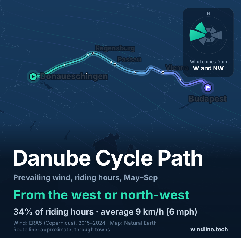
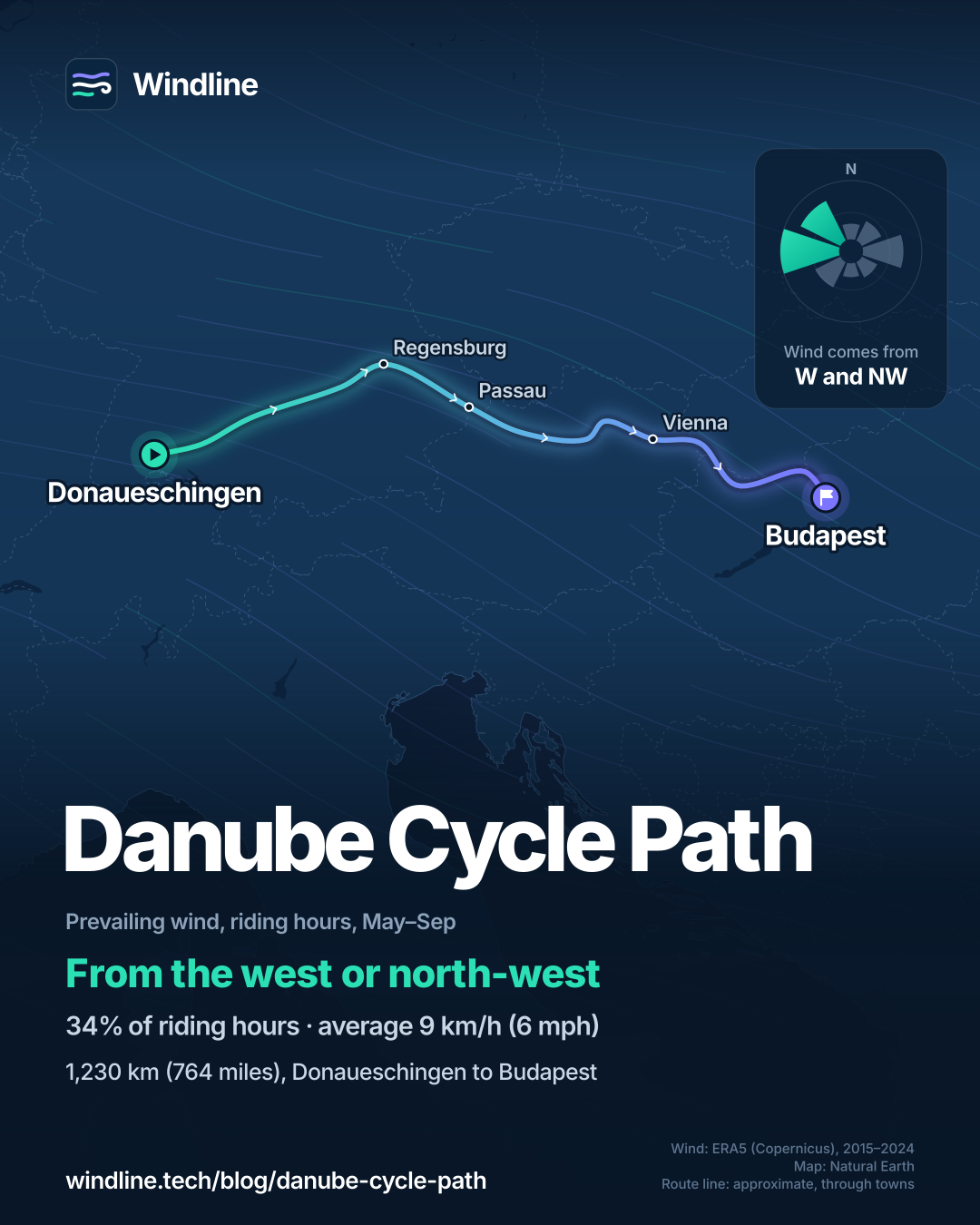
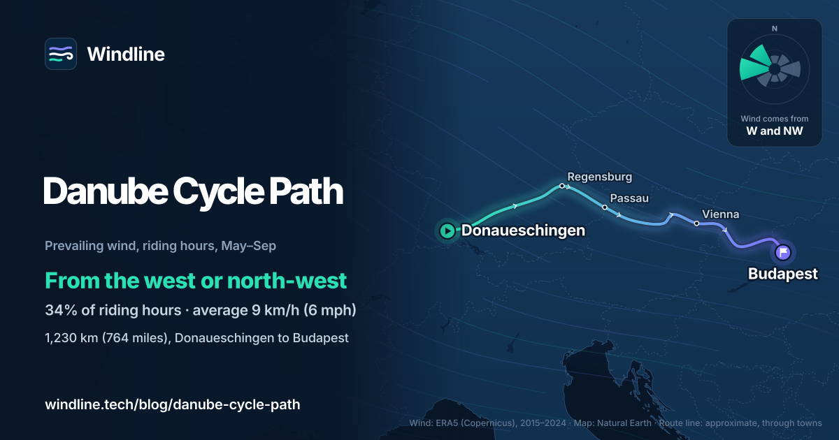
In our May–September riding hours for 2015–2024, the wind came from the west or north-west 34% of the time. Westerly winds (south-west, west and north-west) made up 43% of hours, easterly ones 26%, and 22% were calm. The average was just 9 km/h (6 mph).
These are past averages, not a forecast, and even a light headwind adds up over a week (see how much a headwind slows you down). Our Danube direction guide goes month by month.
How do you get there and back?
By train, with your bike booked on long-distance services. ÖBB carries bikes on regional trains when there's space and you hold a bicycle ticket. On long-distance trains such as the Railjet and ICE, you need a bicycle ticket and a reservation, €3 online as of October 2026.
Upper Austria's Danube board points riders returning from Vienna to Passau to ÖBB, warns bike spaces are limited, and notes there's no return by boat. In Germany, EuroVelo says IC bike spaces are limited in high season, but the regional Donautalbahn has plenty of room. Hungary takes bikes on almost all trains for a small surcharge.
Like flat river riding? North America's nearest match is the car-free Great Allegheny Passage and C&O Canal, 536 km (333 miles) from Pittsburgh to Washington, DC.
Frequently asked questions
Is the Danube Cycle Path good for a first cycle tour?
Yes, especially from Passau to Vienna. EuroVelo describes that section as running on comfortable flat roads, and Upper Austria's tourism board calls its north-bank route family friendly, for children aged 9 and older. Towns are close together, so short days are easy to plan. To set your own daily distance, see [how far you can cycle in a day](/blog/how-far-can-you-cycle-in-a-day/).
Can you ride the Danube Cycle Path in winter?
You can, but it's harder. Two power-station crossings near Linz are closed from December to February, and Hungary's ferry at Szob stops running from 15 October. In our 2015–2024 data, January and February had the most gusty days, 15–18%, and riding-hour highs of just 3–6°C (37–43°F). Upper Austria's tourism board recommends May to October.
Does the Danube Cycle Path go all the way to the Black Sea?
The river route does, as part of EuroVelo 6, which runs 4,700 km (2,921 miles) from Nantes on the Atlantic to Constanța on the Black Sea through 10 countries. EuroVelo says the whole route mixes well-developed sections with parts still being developed or planned. This guide covers the best-known stretch, from Donaueschingen to Budapest.
One link for the whole tour.
Load every stage once. Each day gets a live Good, Fair or Tough rating, and your riders need no app and no account.
Set up your tour →Sources and method
- EuroVelo (European Cyclists' Federation) (2026). EuroVelo 6: Atlantic – Black Sea
- EuroVelo (European Cyclists' Federation) (2026). EuroVelo 6: from Passau to Vienna
- EuroVelo (European Cyclists' Federation) (2026). EuroVelo 6: from Vienna to Budapest
- EuroVelo (European Cyclists' Federation) (2026). EuroVelo 6 in Germany, Austria, Slovakia and Hungary (country pages)
- Deutsche Donau (2026). Donauradweg 2026 (route brochure)
- Oberösterreich Tourismus (2026). Danube cycle path on the north bank, Passau to Bratislava
- Donau Oberösterreich Tourismus (2026). Danube cycle path (with FAQs)
- Donau Niederösterreich Tourismus (2026). Danube Cycle Path stages
- Government of Lower Austria (2016). Donauradweg in Niederösterreich wird immer beliebter (press release)
- Government of Lower Austria (2017). Donauradweg: Jährlich 680.000 Radfahrer zwischen Passau und Wien unterwegs (press release)
- ÖBB (Austrian Federal Railways) (2026). Your bicycle on the train
- Great Allegheny Passage Conservancy (2026). The Ride of Your Life
- Copernicus Climate Change Service (ECMWF) (2026). ERA5 hourly time-series data on single levels from 1940 to present
Route facts are from the official bodies in the sources, as checked on 10 October 2026. The length is our sum of official section figures, as in our Europe list: over 600 km Donaueschingen to Passau (Deutsche Donau), about 320 km Passau to Vienna and 310 km Vienna to Budapest (the section lengths EuroVelo lists), about 1,230 km (764 miles) in all. The 22 to 26 days are our estimate: Deutsche Donau's 12 stages to Passau, the 10 Austrian stages counted by Donau Niederösterreich, and up to about 4 days from the Austrian border to Budapest. Passau to Vienna in a week is our arithmetic: 320 km at the 64 km (40 miles) a day that multi-day riders averaged in the 2016 survey reported by the Government of Lower Austria is five riding days. Best months are Upper Austria's tourism board's recommended season, May to October. Weather across the year: Windline's own analysis of hourly ERA5 reanalysis (Copernicus Climate Change Service, ECMWF), 1 January 2015 to 31 December 2024, downloaded from the Copernicus Climate Data Store, at three sample points along the route (Donaueschingen, Passau and Budapest, nearest 0.25° grid cell), pooled. Riding hours are 08:00 to 17:00 local time. Wind is 10 m (33 ft) wind; the directions shown are the two commonest of eight compass sectors, and months when the hours barely agree on a direction are shown as changeable; hours under 5 km/h (3 mph) count as calm. A gusty day has a riding-hour gust of 50 km/h (31 mph) or more; a wet day has 1 mm or more of rain; start is the 08:00 temperature and high is the warmest riding hour. The direction figures use May to September riding hours only; westerly means the south-west, west and north-west sectors, easterly the north-east, east and south-east sectors. These are averages of past seasons, not forecasts. Contains modified Copernicus Climate Change Service information (ERA5, 2015–2024); neither the European Commission nor ECMWF is responsible for any use of this information. The map's route line joins town centres in riding order; it is approximate and not an official route. Conversions use 1 mile = 1.609 km, rounded.
About the author
Wes Thomson, Founder, Windline. Wes Thomson builds Windline, live wind and weather forecasts timed to when riders reach each stretch of road. He built it for his own 2,093 km tour from Pont Drift to Cape Town, and writes these guides with the same focus: what the wind will do to your ride, and how to plan around it.