Cycling the P'tit Train du Nord: Quebec's Laurentian rail trail
Plan a P'tit Train du Nord ride through Quebec's Laurentians with its sections, a year of weather, which way to ride, and the shuttle.
The short answer
The P'tit Train du Nord is an almost car-free rail trail through Quebec's Laurentians, 234 km (145 miles) in all, with a classic 201 km (125-mile) tour from Mont-Laurier to Saint-Jérôme over three or four days. It's mostly paved, never steeper than 4%, and rideable from late spring through October.
Key takeaways
- The classic tour runs 201 km (125 miles), Mont-Laurier to Saint-Jérôme, in three or four days.
- Mostly asphalt with some stone dust, a 4% maximum gradient, and a marker every kilometre.
- Summer is mild but wet: rain falls on 45–46% of days from June to August.
- A shuttle from Saint-Jérôme carries bikes north; luggage can travel between inns.
Definitions
- Linear park
- A long, narrow park built along a corridor such as an old railway, here used as a multi-use trail.
- Stone dust
- A packed surface of fine crushed rock, firm when dry but softer after rain.
What is the P'tit Train du Nord?
The P'tit Train du Nord is a linear park on an old railway line through Quebec's Laurentians. Its own site gives 234 km (145 miles) in all; the classic tour, from km 0 at Saint-Jérôme to Mont-Laurier, is 201 km (125 miles).
It's the best-known ride on Vélo Québec's Route Verte, a network of more than 5,000 km (3,100 miles), and one of the gentlest tours in our best cycling routes in North America. It's also among the world's great cycling routes.
| Fact | Detail |
|---|---|
| Length | 234 km (145 miles) in all; 201 km (125 miles), Mont-Laurier to Saint-Jérôme |
| Province | Quebec, Canada |
| Usual days | 3–4 for the 201 km |
| Surface | Asphalt and stone dust, 86% paved |
| Gradient | 4% at most |
| Signage | A numbered marker every kilometre; Route Verte 2 signs |
| Best months | June to October |
| Entry | Free, all year |
Which sections do people ride?
The trail's site splits it into four parts; any one makes a day ride.
- Mont-Laurier to La Macaza. The quiet north. Nominingue's and Rivière-Rouge's old stations hold exhibition centres.
- Labelle to Val-Morin. Past Labelle's railway museum, Mont-Tremblant and Sainte-Agathe-des-Monts, whose old station is a tourist office.
- Sainte-Adèle to Saint-Jérôme. Prévost's 1898 station has a café; Saint-Jérôme's stone station marks km 0.
- Mirabel to Bois-des-Filion. A southern extension beyond Saint-Jérôme.
Set your stages with how far you can cycle in a day.
Want this for your own route? Windline shows the wind for every stretch, timed to your pace. Free. Make a free ride page →
What's the weather like through the year?
Summer is mild and fairly calm but often wet; spring and autumn are cooler and gustier.
Weather across the year on the P'tit Train du Nord (Mont-Laurier to Saint-Jérôme, Quebec), 2015–2024
| Month | Wind from | Average wind, km/h (mph) | Gusty days | Start → high, °C (°F) | Wet days |
|---|---|---|---|---|---|
| Jan | NW, W | 11 (7) | 10% | -12° (10°) → -7° (19°) | 42% |
| Feb | W, NW | 12 (8) | 16% | -12° (10°) → -5° (22°) | 44% |
| Mar | NW, W | 13 (8) | 19% | -6° (21°) → 1° (33°) | 41% |
| Apr | NW, W | 13 (8) | 25% | 1° (34°) → 9° (47°) | 45% |
| May | ~Changeable | 12 (7) | 18% | 10° (50°) → 18° (64°) | 38% |
| Jun | SW, W | 11 (7) | 15% | 15° (59°) → 22° (71°) | 45% |
| Jul | SW, W | 10 (6) | 11% | 18° (64°) → 25° (77°) | 46% |
| Aug | SW, NW | 10 (6) | 7% | 16° (61°) → 23° (74°) | 46% |
| Sep | SW, S | 10 (6) | 8% | 12° (53°) → 20° (68°) | 33% |
| Oct | SW, S | 12 (8) | 16% | 5° (41°) → 12° (54°) | 44% |
| Nov | NW, W | 13 (8) | 17% | -1° (30°) → 3° (38°) | 44% |
| Dec | W, NW | 12 (7) | 12% | -7° (19°) → -3° (26°) | 46% |
July is the warmest month: the warmest riding hour averages 25°C (77°F), and 08:00 starts are 18°C (64°F). From June to August, 1 mm or more of rain falls on 45–46% of days, so pack a rain jacket. September is the driest month in the table, wet on 33% of days, with highs of 20°C (68°F) and a gust of 50 km/h (31 mph) or more on just 8% of days. By October, highs fall to 12°C (54°F) and starts to 5°C (41°F), while May's wind is light and changeable.
Which way should you ride the P'tit Train du Nord?
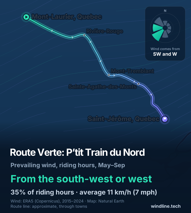
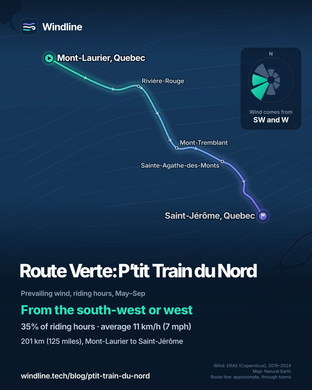
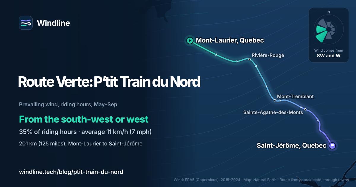
The shuttle company says riding south, from Mont-Laurier to Saint-Jérôme, is the common choice, and in summer that's usually the better way for the wind too.
From May to September, the riding-hour wind came from the south-west or west in 35% of hours, averaging 11 km/h (7 mph), and 13% of hours were calm. The trail runs south-east overall, so a westerly or north-westerly is mostly behind southbound riders, and a south-westerly mostly side-on. Counting all eight directions, the wind was broadly behind southbound riders in about 39% of hours and against them in about 24%.
These are averages of past seasons, not a forecast: for your actual days, read a route-timed forecast. Other routes are in our prevailing winds guide.
How do you get there and back?
Start and finish at Saint-Jérôme, km 0: a shuttle takes you north, and you ride back.
- Train: commuter trains run from Montréal and Laval to Saint-Jérôme with bikes on board, free according to Vélo Québec. The station is next to the shuttle office.
- Car: park at Place de la Gare in Saint-Jérôme, in a lot watched by security cameras.
- Shuttle and luggage: a bus company at km 0 carries riders and bikes north at 08:00, by reservation, and moves luggage between inns or campsites.
- Sleeping: inns, B&Bs and campsites, many certified "Bienvenue cyclistes". No camping on the trail itself.
- Rules: keep to 22 km/h (14 mph), or 10 km/h (6 mph) near towns, and stop at road crossings.
- Autumn 2026: from 13 October, two short sections near Prévost and Saint-Jérôme close for about six weeks, with no detour.
For another car-free tour, compare the Katy Trail, and plan with our multi-day tour guide.
Frequently asked questions
Is the P'tit Train du Nord paved all the way?
No. The trail says some sections are asphalt and others rock dust, and its interactive map shows which: pink for paved, brown for gravel. Vélo Québec puts the paved share at 86%. Wider tyres are more comfortable on stone dust, and the trail asks riders to keep off it while closed from autumn to spring.
Do you have to pay to ride the P'tit Train du Nord?
No. The trail's own site says access is free at all times, summer and winter. The non-profit that runs it relies on donations and souvenir sales to maintain and patrol it. You pay only for what you use: rooms, campsites, food, bike rental, and the shuttle or luggage service.
Can you cycle the P'tit Train du Nord in winter?
Only on a fat bike, and only in set places. From mid-December to early April the trail is groomed for skiing and walking, and some sections are kept for snowmobiles. Fat bikes may use the walking corridor on the west side from Saint-Jérôme to Val-David and from Saint-Faustin to Mont-Tremblant. Other bikes aren't allowed on the groomed surfaces.
Get the wind for your ride.
Upload a GPX, add your start time and pace, and see the headwind, gusts, rain and heat for every stretch of the route, timed to when you’ll be there. Free for riders.
Make a free ride page →Sources and method
- Parc linéaire Le P'tit Train du Nord (2026). Prepare your trip
- Parc linéaire Le P'tit Train du Nord (2026). FAQ
- Parc linéaire Le P'tit Train du Nord (2026). Ride
- Parc linéaire Le P'tit Train du Nord (2026). Home page and trail conditions
- Parc linéaire Le P'tit Train du Nord (2022). Communiqué de presse: complete opening of the linear park, 20 May 2022
- Vélo Québec (Le Québec à vélo) (2026). Parc linéaire Le P'tit Train du Nord
- Vélo Québec (2017). The Route verte: a provincial treasure
- Vélo Québec (2020). Vélo Québec launches the 10th edition of the guide La Route verte du Québec
- Autobus Le Petit Train du Nord (2026). Transport de cyclistes
- Copernicus Climate Change Service (ECMWF) (2026). ERA5 hourly time-series data on single levels from 1940 to present
- Copernicus Climate Change Service (ECMWF) (2026). ERA5 hourly data on single levels from 1940 to present
- Natural Earth (2026). Terms of use (public domain map data)
Route facts come from the P'tit Train du Nord's own website (prepare your trip, FAQ, ride, home page and a 2022 press release), Vélo Québec (its Le Québec à vélo trail page and its Route verte pages), and the shuttle company's own page, all read on 10 October 2026. The whole linear park is 234 km by the trail's own figure (Vélo Québec's trail page says 235 km); the classic tour from Saint-Jérôme to Mont-Laurier is 201 km, and three or four days is the trail's own suggestion. Best months: the trail opened fully on 20 May in 2022 and says its season runs through October, and the trail is closed from autumn to spring; we shade June to October, matching our North America list's "summer to October". Conversions use 1 mile = 1.609 km, rounded. The weather table and the wind figures are Windline's own analysis of Copernicus ERA5 reanalysis, 1 January 2015 to 31 December 2024, downloaded from the Copernicus Climate Data Store (hourly time series for the nearest 0.25° grid cell), at three sample points along the route (Mont-Laurier, Labelle and Saint-Jérôme), with hours and days pooled across the three. Riding hours are 08:00 to 17:00 local time. Wind is the 10 m (33 ft) wind; the direction is the commonest two of eight compass sectors, hours under 5 km/h (3 mph) count as calm, and months with no steady direction are called light and changeable. A gusty day has a riding-hour gust of 50 km/h (31 mph) or more; a wet day has 1 mm or more of rain; start is the 08:00 temperature and high is the warmest riding hour. The summer wind (May to September) is from the same data. For direction, we took the trail's overall bearing from Mont-Laurier to Saint-Jérôme as south-east (about 126°) and sorted the eight wind sectors by whether they push mostly along or against that line: winds from the west, north-west and north are broadly behind southbound riders (15.7% + 15.5% + 7.5% = 38.7% of riding hours, about 39%); winds from the south, south-east and east are broadly against them (11.7% + 6.7% + 5.5% = 23.9%, about 24%); south-westerlies and north-easterlies are mostly side-on, and 12.7% of hours were calm. These are averages of past seasons, not forecasts. The map's line is an approximate line through town waypoints, not an official route map; basemap from Natural Earth (public domain). Contains modified Copernicus Climate Change Service information (ERA5, 2015–2024); neither the European Commission nor ECMWF is responsible for any use of this information.
About the author
Wes Thomson, Founder, Windline. Wes Thomson builds Windline, live wind and weather forecasts timed to when riders reach each stretch of road. He built it for his own 2,093 km tour from Pont Drift to Cape Town, and writes these guides with the same focus: what the wind will do to your ride, and how to plan around it.