Cycling the Blue Ridge Parkway: weather by month and which way to ride
Plan a Blue Ridge Parkway ride with its weather by month, the prevailing wind, the big climbs, tunnel rules, closures and campgrounds.
The short answer
Cycling the Blue Ridge Parkway means 755 km (469 miles) of mountain road between Shenandoah and Great Smoky Mountains national parks, with no bike lanes, over two dozen tunnels and about 14,800 m (48,600 ft) of climbing. Most riders need 10–12 days. Go between May and October, and check the road closures each morning.
Key takeaways
- The parkway runs 755 km (469 miles) through Virginia and North Carolina, with a milepost every mile.
- Southbound you climb about 14,800 m (48,600 ft); northbound is almost the same.
- Lights or reflectors are required in tunnels, between sunset and sunrise, and in low visibility.
- On 10 October 2026, mileposts 344.2–355.3 near Mount Mitchell were still closed after Hurricane Helene.
Definitions
- Milepost
- The numbered markers along the parkway, from 0 near Waynesboro, Virginia, to 469 near Cherokee, North Carolina, used in place of street addresses.
What is the Blue Ridge Parkway?
It's a 755 km (469-mile) scenic road run by the US National Park Service (NPS), linking Shenandoah National Park near Waynesboro, Virginia, with Great Smoky Mountains National Park near Cherokee, North Carolina. Cycling the Blue Ridge Parkway is allowed on the paved road, but it was built for cars and has no bike lanes.
It's one of our 10 most popular cycling tours in North America, and part of our guide to the world's great cycling routes.
| Fact | Detail |
|---|---|
| Length | 755 km (469 miles), milepost 0 to 469 |
| States | Virginia and North Carolina |
| Usual days | 10–12 |
| Surface | Paved road, no bike lanes; bikes banned on trails |
| Signage | A milepost marker every mile |
| Climbing | About 14,800 m (48,600 ft) |
| Elevation | 198–1,843 m (649–6,047 ft) |
| Best months | May–October |
Which sections do people ride?
Most riders split it by state, or at the big cities: the NPS names Roanoke, Boone and Asheville as the largest along the way.
- Virginia, mileposts 0–216.9. The northern part, from Rockfish Gap to the state line. Its longest climb, southbound, gains 1,007 m (3,305 ft) between mileposts 63.0 and 76.7.
- North Carolina, mileposts 216.9–469. It has all but one of the tunnels. Southbound, mileposts 443.1–451.2 gain 747 m (2,450 ft). Starting north from Cherokee, the first 11 km (7 miles) gain 683 m (2,240 ft).
The NPS lists every major climb by milepost. Split the days with how far you can cycle in a day.
Want this for your own route? Windline shows the wind for every stretch, timed to your pace. Free. Make a free ride page →
What's the weather like through the year?
Summer is calm but often wet, and autumn is drier and cooler.
Weather across the year on the Blue Ridge Parkway, 2015–2024
| Month | Wind from | Average wind, km/h (mph) | Gusty days | Start → high, °C (°F) | Wet days |
|---|---|---|---|---|---|
| Jan | NW, W | 11 (7) | 28% | -1° (30°) → 6° (42°) | 37% |
| Feb | S, NW | 11 (7) | 31% | 1° (35°) → 9° (49°) | 43% |
| Mar | NW, S | 12 (7) | 33% | 4° (39°) → 13° (56°) | 39% |
| Apr | NW, W | 12 (7) | 33% | 8° (47°) → 18° (64°) | 38% |
| May | W, NW | 9 (6) | 18% | 14° (57°) → 22° (71°) | 47% |
| Jun | NW, W | 9 (5) | 10% | 18° (64°) → 26° (78°) | 45% |
| Jul | W, NW | 7 (4) | 5% | 20° (68°) → 28° (82°) | 52% |
| Aug | W, NW | 6 (4) | 3% | 18° (65°) → 27° (80°) | 47% |
| Sep | ~Changeable | 8 (5) | 5% | 15° (59°) → 24° (75°) | 37% |
| Oct | NW, W | 9 (5) | 11% | 9° (48°) → 19° (66°) | 26% |
| Nov | NW, S | 9 (6) | 16% | 4° (39°) → 13° (55°) | 27% |
| Dec | S, W | 10 (6) | 22% | 2° (35°) → 9° (48°) | 33% |
Gusts ease through the season: about a third of days are gusty in March and April, falling to 3–5% from July to September. July is the wettest month, with 52% wet days, and it's warmest, from 20°C (68°F) at 08:00 to 28°C (82°F). October is the driest month of the season at 26%, rising from 9°C (48°F) to 19°C (66°F). September's wind is changeable in direction.
Which way should you ride it?
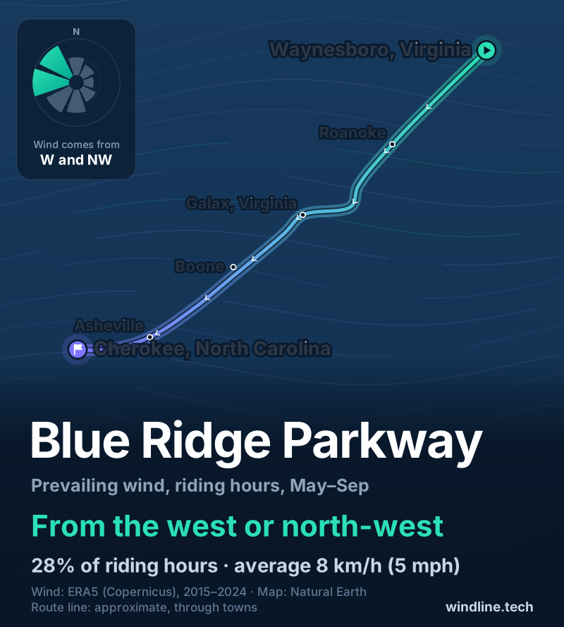
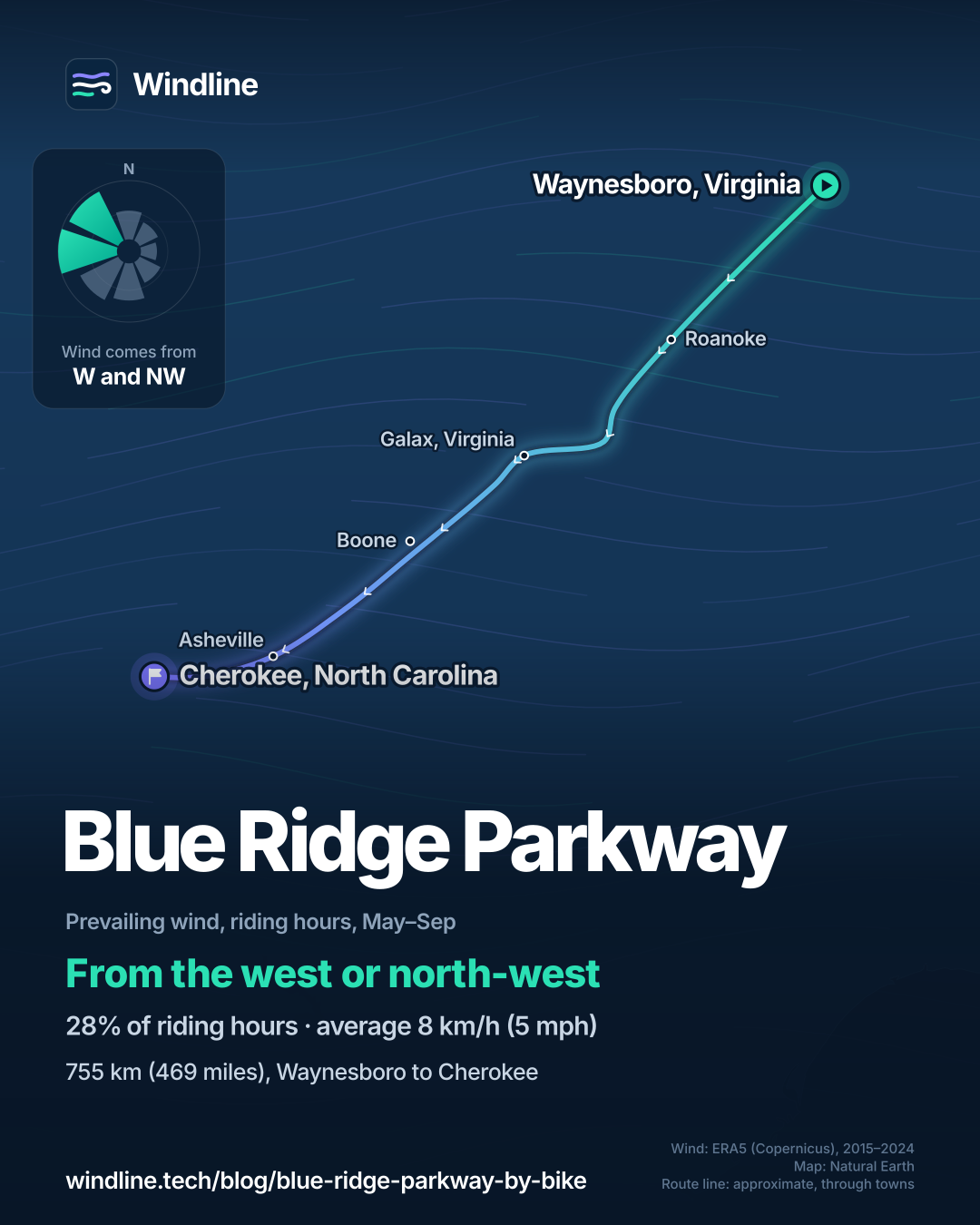
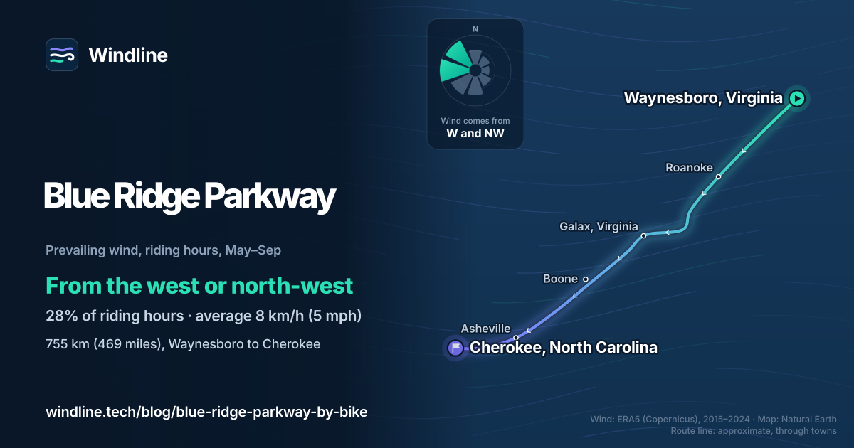
Northbound has a slight edge on wind, but it barely matters. From May to September, the riding-hour wind blows most often from the west or north-west (28% of hours), averaging 8 km/h (5 mph), and 30% of hours are calm.
The parkway runs broadly south-west from Waynesboro to Cherokee. Heading south, a westerly or north-westerly sits ahead and to your right; heading north, it's mostly behind you. At these speeds the climbing counts for more, and the NPS totals are almost equal: 14,813 m (48,601 ft) southbound and 14,850 m (48,722 ft) northbound.
These are averages of past seasons, not a forecast. Our prevailing winds guide explains the method, and how windy is too windy covers the gusty days.
What should you know before cycling the Blue Ridge Parkway?
Check closures daily, carry lights and book campgrounds early. On 10 October 2026, the NPS listed mileposts 344.2–355.3, from NC Highway 80 to Mount Mitchell State Park, as closed after Hurricane Helene, with recreation of any kind prohibited. The park expects its road repairs to finish by late 2026.
- Lights: a white light or reflector visible 152 m (500 ft) ahead and a red one visible 61 m (200 ft) behind, in tunnels, between sunset and sunrise and in low visibility.
- Riding: single file, well to the right. You may ride sections gated for bad weather, with care, but never a construction closure.
- Camping: only at established campgrounds. The parkway's eight open from May to late October; Linville Falls was closed on 10 October 2026. Some are too far apart for convenient cycling, the NPS warns.
- Water: seasonal, at picnic areas, campgrounds and visitor centres. Treat stream water.
- Getting there: Interstates 64, 81 and 77 in Virginia, and 40 and 26 in North Carolina, have signed access. Car GPS units don't recognise mileposts.
If you like it, compare Canada's Icefields Parkway or Scotland's North Coast 500.
Frequently asked questions
Do you have to pay to cycle the Blue Ridge Parkway?
No. The National Park Service charges no fee to travel the parkway and needs no entrance pass. You pay only to camp: $30 a night at its campgrounds, as of October 2026, first come, first served or booked up to six months ahead on Recreation.gov. Showers are at Julian Price and Mount Pisgah only, so plan the other nights around that.
Can you ride an e-bike on the Blue Ridge Parkway?
Yes, wherever ordinary bicycles may go. The National Park Service defines an e-bike as a two- or three-wheeled cycle with working pedals and a motor under 750 watts. Like every bike, it's allowed only on the paved road and in parking areas, never on trails or walkways, and it must follow the same light, single-file and speed rules.
Is the whole Blue Ridge Parkway open in 2026?
Not yet. On 10 October 2026 the NPS road status page listed mileposts 344.2–355.3, from NC Highway 80 to Mount Mitchell State Park, as closed after Hurricane Helene, with recreation of any kind prohibited. The park expects its road repairs to finish by late 2026. Weather closures come and go too, so check that page each morning.
Get the wind for your ride.
Upload a GPX, add your start time and pace, and see the headwind, gusts, rain and heat for every stretch of the route, timed to when you’ll be there. Free for riders.
Make a free ride page →Sources and method
- US National Park Service (2024). Blue Ridge Parkway: bicycling the parkway
- US National Park Service (2021). Bicycle the Blue Ridge Parkway
- US National Park Service (2024). Blue Ridge Parkway: directions
- US National Park Service (2026). Blue Ridge Parkway: road status and closures (10 October 2026)
- US National Park Service (2026). Blue Ridge Parkway: Helene impacts and recovery
- US National Park Service (2026). Ongoing work to reopen the Blue Ridge Parkway between Mount Mitchell and Little Switzerland expected to be complete by late 2026
- US National Park Service (2025). Blue Ridge Parkway: camping
- US National Park Service (2024). Blue Ridge Parkway: fees and passes
- Copernicus Climate Change Service (ECMWF) (2026). ERA5 hourly time-series data on single levels from 1940 to present
- Copernicus Climate Change Service (ECMWF) (2026). ERA5 hourly data on single levels from 1940 to present
- Natural Earth (2026). Terms of use (public domain map data)
Facts about the parkway (length, mileposts, tunnels, lights, rules, climbs, campgrounds, fees and closures) are from the US National Park Service pages listed in the sources, read on 10 October 2026. The two NPS bicycling pages differ on the tunnels (26 or 25 in North Carolina, plus 1 in Virginia), so we say "over two dozen". Climbing totals are the NPS figures for major uphill climbs (credited there to Tom De Vaughn): 48,601 ft southbound and 48,722 ft northbound. Best months: the NPS says cycling is for spring, summer and autumn, with parts often closed by ice in winter, and its campgrounds open from May to late October; we shade May to October. Usual days are our arithmetic, as in our North America list: 755 km at 64–80 km (40–50 miles) a day on a hilly route is 10–12 days. Conversions use 1 mile = 1.609 km and 1 m = 3.281 ft, rounded. The weather table and wind figures are Windline's own analysis of ERA5 reanalysis (Copernicus Climate Change Service, ECMWF), 1 January 2015 to 31 December 2024, via the Copernicus Climate Data Store, for riding hours 08:00 to 17:00 local time, at three sample points along the route (Waynesboro, Virginia; Galax, Virginia; Cherokee, North Carolina), using the nearest 0.25° grid cell and pooling hours and days across the points. Wind is at 10 m (33 ft); directions are the commonest two of eight compass sectors; hours under 5 km/h (3 mph) count as calm; months where the hours barely agree on a direction are called changeable in direction. A gusty day has a riding-hour gust of 50 km/h (31 mph) or more; a wet day has 1 mm or more of rain; start is the 08:00 temperature and high is the warmest riding hour. The prevailing wind is for May to September. ERA5 cells are about 25–30 km (16–19 miles) across, so they smooth out the ridges, and the high points run colder and windier. These are averages of past seasons, not forecasts. Credit: contains modified Copernicus Climate Change Service information (ERA5, 2015–2024); neither the European Commission nor ECMWF is responsible for any use of this information. The map's route line is an approximate line through towns, not an official route map; basemap from Natural Earth (public domain); town coordinates from Wikipedia.
About the author
Wes Thomson, Founder, Windline. Wes Thomson builds Windline, live wind and weather forecasts timed to when riders reach each stretch of road. He built it for his own 2,093 km tour from Pont Drift to Cape Town, and writes these guides with the same focus: what the wind will do to your ride, and how to plan around it.