Mallorca 312 route: the climbs, cut-offs and April wind
See the 312's climbs in order, the cut-offs to beat and which stretches usually face the April wind.
The short answer
The Mallorca 312 route is a 312 km (194 mile) loop from Platja de Muro, Mallorca, Spain: west over the Serra de Tramuntana to Andratx, back across the island's centre, then east to Artà and home. The 2026 course climbed 5,050 m (16,568 ft). The 2027 edition starts at 06:30 on Saturday 24 April.
Key takeaways
- Nine climbs come in the first 150 km (93 miles), topping out at 899 m (2,949 ft) on Puig Major.
- The 2026 cut-offs: km 97 by 11:20, km 218 by 16:40, Artà by 19:55.
- April riding-hour wind averaged 15 km/h (9 mph), changeable in direction.
- Ariany to Artà met a headwind in 43% of April riding hours, the most of any stretch.
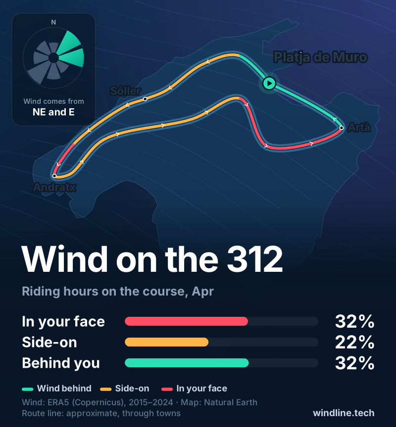
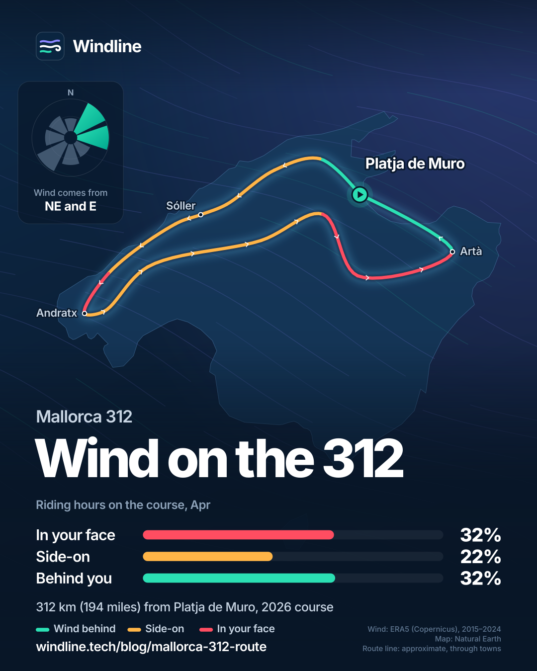
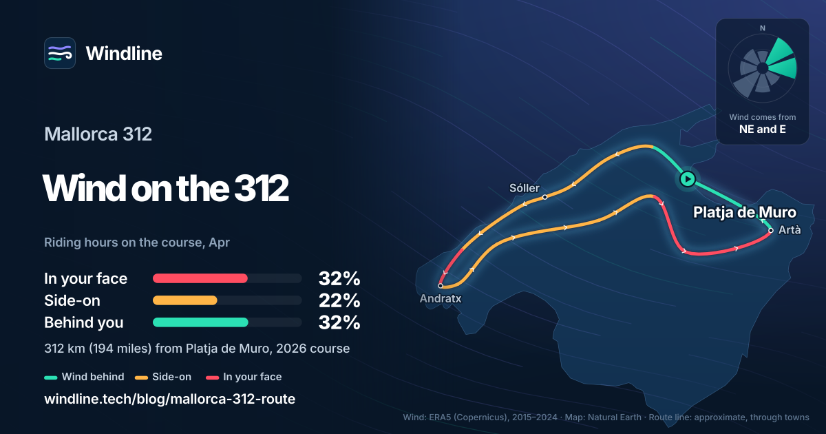
What is the Mallorca 312 route?
The Mallorca 312 route is the longest course of a one-day sportive on Mallorca, Spain: a 312 km (194 mile) loop from Platja de Muro on roads closed to traffic. It takes in roads from our guide to cycling in Mallorca, one of the best cycling routes in Europe and of the world's great cycling routes.
| The course at a glance | |
|---|---|
| Length | 312 km (194 miles), a loop from Platja de Muro |
| Climbing | 5,050 m (16,568 ft) on the 2026 profile |
| Shorter routes | 226 km (140 miles) and 167 km (104 miles), same start |
| Date and start | Saturday 24 April 2027, 06:30 to 07:00 by start box |
| Finish closes | 20:40 for the 312 |
| Roads | Closed to traffic, signposted |
| Riders | Up to 8,500 |
Figures from the organiser, as of October 2026. The 2027 course isn't published yet, so course details below are 2026's. Windline isn't connected with the event.
Which climbs come where, and when are the cut-offs?
The climbing is packed into the first 150 km (93 miles); after that the course is much flatter.
| Climb (2026 profile) | Summit at | Height |
|---|---|---|
| Coll de Femenia | km 33 | 519 m (1,703 ft) |
| Puig Major | km 55 | 899 m (2,949 ft) |
| Coll d'en Bleda | km 74 | 226 m (741 ft) |
| Coll de sa Pedrissa | km 87 | 450 m (1,476 ft) |
| Coll d'en Claret | km 93 | 550 m (1,804 ft) |
| Coll des Pi | km 115 | 330 m (1,083 ft) |
| Coll de sa Gramola | km 123 | 358 m (1,175 ft) |
| Galilea | km 143 | 410 m (1,345 ft) |
| Grau de Superna | km 150 | 465 m (1,526 ft) |
The 2026 cut-offs were km 97 at 11:20, km 218 at 16:40 and Artà, km 285, at 19:55, with seven food stops from Gorg Blau (km 50) to Ariany (km 244).
Running a tour? Give every rider one live forecast link for every stage. Set up your tour →
What's the weather like through the year?
April sits between Mallorca's windy winter and calmer summer.
Weather across the year on the Mallorca 312, 2015–2024
| Month | Wind from | Average wind, km/h (mph) | Gusty days | Start → high, °C (°F) | Wet days |
|---|---|---|---|---|---|
| Jan | SW, NW | 17 (11) | 23% | 11° (51°) → 14° (58°) | 23% |
| Feb | ~Changeable | 16 (10) | 21% | 11° (51°) → 15° (58°) | 21% |
| Mar | ~Changeable | 18 (11) | 24% | 12° (54°) → 16° (61°) | 23% |
| Apr | ~Changeable | 15 (9) | 14% | 14° (56°) → 18° (64°) | 23% |
| May | ~Changeable | 13 (8) | 8% | 17° (63°) → 21° (71°) | 18% |
| Jun | ~Changeable | 12 (7) | 3% | 22° (71°) → 26° (79°) | 11% |
| Jul | E, NE | 11 (7) | 3% | 24° (76°) → 29° (85°) | 3% |
| Aug | NE, E | 12 (7) | 4% | 24° (76°) → 29° (84°) | 10% |
| Sep | NE, E | 13 (8) | 7% | 22° (71°) → 26° (79°) | 29% |
| Oct | ~Changeable | 14 (9) | 11% | 19° (66°) → 23° (73°) | 25% |
| Nov | ~Changeable | 17 (11) | 24% | 15° (59°) → 18° (65°) | 33% |
| Dec | SW, W | 15 (9) | 18% | 12° (54°) → 16° (61°) | 21% |
April's riding-hour wind averaged 15 km/h (9 mph), changeable in direction: north-east and east were commonest, but only 32% of hours between them. 14% of days were gusty and 23% wet, with 14°C (56°F) at 08:00 and highs of 18°C (64°F). For the whole island, see Mallorca cycling weather.
Where does the April wind usually hit the course?
Late in the day, between Ariany and Artà. Over the whole loop a headwind came in 32% of April riding hours, the same either way round.
| Stretch (approx. km) | Headwind | Crosswind | Tailwind |
|---|---|---|---|
| Platja de Muro to Pollença (0–20) | 18% | 38% | 32% |
| Tramuntana, Pollença to Estellencs (20–112) | 34–35% | 12–14% | 35% |
| Estellencs to Andratx (112–129) | 38% | 26% | 29% |
| Andratx to Esporles (129–160) | 30–32% | 24–26% | 35–38% |
| Esporles to Sa Pobla (160–218) | 35% | 12% | 35% |
| Sa Pobla to Ariany (218–242) | 30% | 37% | 21% |
| Ariany to Artà (242–285) | 43% | 22% | 23% |
| Artà to Platja de Muro (285–312) | 18% | 36% | 34% |
In the mountains, headwind and tailwind were about equal. The run to Artà heads east into the commonest winds, after 240 km (149 miles) and just before a cut-off. The last 27 km (17 miles) turns west, with the wind more often behind or beside you.
These are past averages, not a forecast. See how much a headwind slows you down.
How do you get to the start, and what are the rules?
Fly to Palma, about 40 minutes by car from Platja de Muro, the organiser says. Collect your bib in person.
- Bibs: at the expo, Avenida s'Albufera 33, Thursday 22 and Friday 23 April 2027, 09:00 to 21:00.
- Who can ride: over-18s, or over-15s with parental consent. Helmets are compulsory.
- Entries: places riders give up are resold on the official marketplace, 1 December 2026 to 31 March 2027.
Frequently asked questions
Can you switch to a shorter distance during the Mallorca 312?
Yes. The rules let you change to the 226 km (140 mile) or 167 km (104 mile) route during the ride, as long as you're inside the cut-off times. The splits are signposted. If you abandon within the time limit, a bus and support vehicle take you and your bike to the finish.
How fast do you need to ride to finish the Mallorca 312?
From a 06:30 start, reaching km 97 by 11:20 means about 20 km/h (12 mph), stops included, over the two biggest climbs. Finishing by 20:40 means about 22 km/h (14 mph), or nearly 23 km/h (14 mph) from a 07:00 box. Riders overtaken by the end-of-event vehicle are out.
Can the Mallorca 312 be stopped because of strong wind?
Yes. The rules say the organiser, advised by Civil Protection, may suspend part or all of the ride for adverse weather, naming storms, strong winds and hail. Official warnings always come first. For the gusts that make riding unsafe, see [how windy is too windy to cycle](/blog/how-windy-is-too-windy-to-cycle/).
One link for the whole tour.
Load every stage once. Each day gets a live Good, Fair or Tough rating, and your riders need no app and no account.
Set up your tour →Sources and method
- Mallorca 312 OK Mobility (312 Bike & Tours) (2026). Mallorca 312 (home page, 2027 date and rider numbers)
- Mallorca 312 OK Mobility (312 Bike & Tours) (2026). Mallorca 312: route and altimetry (map, profile and 2026 itinerary)
- Mallorca 312 OK Mobility (312 Bike & Tours) (2026). Rules
- Mallorca 312 OK Mobility (312 Bike & Tours) (2026). Information for the cyclist
- Copernicus Climate Change Service (ECMWF) (2026). ERA5 hourly time-series data on single levels from 1940 to present
Course facts are from the organiser's website, checked on 11 October 2026. The 2027 date, start times, finish closing times, age limits, closed roads, distance changes and weather suspension are from the 2027 rules; bib collection, the airport transfer time and the resale marketplace from the organiser's information page; the course, climbs, summit heights, total climbing, feed stations and intermediate cut-offs from the 2026 map, profile and itinerary on the course page, because the 2027 course and timetable were not yet published. The 2026 itinerary gave 20:50 for the finish; the 2027 rules give 20:40, which we use. Average speeds are our arithmetic: distance divided by the time from the start to each cut-off, stops included. Best month is the event month, April. Weather across the year: Windline's own analysis of hourly ERA5 reanalysis (Copernicus Climate Change Service, ECMWF), 1 January 2015 to 31 December 2024, downloaded from the Copernicus Climate Data Store, at three sample points round the course (Sóller, Es Capdellà and Artà, nearest 0.25° grid cell), pooled. Riding hours are 08:00 to 17:00 local time. Wind is 10 m (33 ft) wind; the two directions given are the commonest of eight compass sectors, and months when the hours barely agree on a direction are shown as changeable; hours under 5 km/h (3 mph) count as calm. A gusty day has a riding-hour gust of 50 km/h (31 mph) or more; a wet day has 1 mm or more of rain; start is the 08:00 temperature and high is the warmest riding hour. Headwind, crosswind and tailwind shares use April riding hours only, along our map line, which joins 15 towns and passes in riding order with straight stretches; each stretch uses its nearest sample point. A headwind is wind within 60 degrees of the direction of travel, a tailwind beyond 120 degrees, and hours under 6 km/h (4 mph) count as calm. Stretch kilometres are approximate, from the 2026 profile. These are averages of past seasons, not forecasts. Contains modified Copernicus Climate Change Service information (ERA5, 2015–2024); neither the European Commission nor ECMWF is responsible for any use of this information. The map's route line is approximate and not the official route. Conversions use 1 mile = 1.609 km, 1 ft = 0.3048 m and °F = °C × 1.8 + 32, rounded.
About the author
Wes Thomson, Founder, Windline. Wes Thomson builds Windline, live wind and weather forecasts timed to when riders reach each stretch of road. He built it for his own 2,093 km tour from Pont Drift to Cape Town, and writes these guides with the same focus: what the wind will do to your ride, and how to plan around it.