The Lesotho Traverse: Maseru to Sani Pass by bike
Plan an eight-day crossing of the Mountain Kingdom, from trading posts and food stops to the weather each month and the Sani Pass border.
The short answer
The Lesotho Traverse is a 502 km (312 mile) bikepacking route across Lesotho, from Maseru to Sani Pass, 85% unpaved, with 13,442 m (44,100 ft) of climbing. Riders usually take eight days. Its makers recommend October to December, before summer thunderstorms turn the dirt roads to mud.
Key takeaways
- Eight days on mostly two-track and footpaths, topping out at 3,246 m (10,650 ft).
- Ride October to December; summer thunderstorms bring lightning and mud.
- In past springs, westerly winds blew in 62% of riding hours, behind riders heading east.
- Carry two days' food from Thaba-Tseka, and reach Sani Pass before the border closes.
What is the Lesotho Traverse?
The Lesotho Traverse is a bikepacking route across the Mountain Kingdom, from the capital, Maseru, to a final descent down Sani Pass into South Africa. It was published by BIKEPACKING.com and is one of our 10 most popular cycling tours in Africa, in our guide to the world's great cycling routes.
| The route at a glance | |
|---|---|
| Length | 502 km (312 miles), Maseru to Sani Pass |
| Countries | Lesotho, ending in South Africa |
| Usual days | 8 |
| Surface | 85% unpaved: mostly two-track and footpaths, 5% singletrack |
| Climbing | 13,442 m (44,100 ft); high point 3,246 m (10,650 ft) |
| Signage | Navigate with the makers' GPX |
| Best months | October to December |
Which sections do people ride?
The crossing falls into four parts between its towns. Its makers found the second half the most impressive.
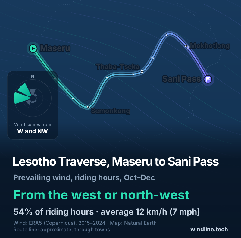
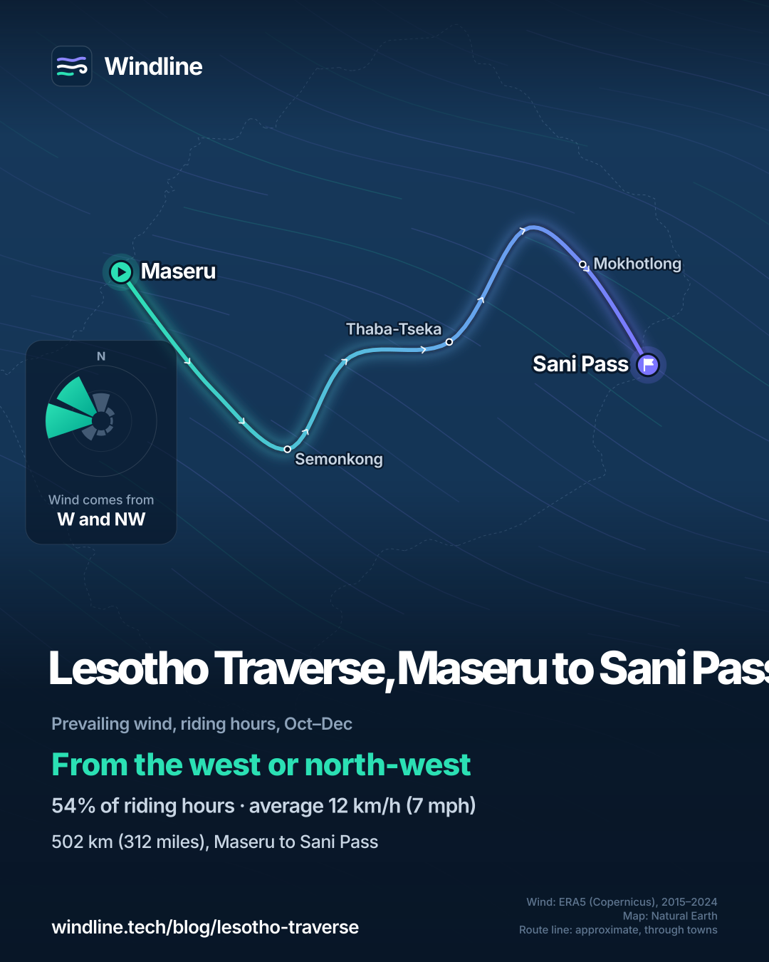
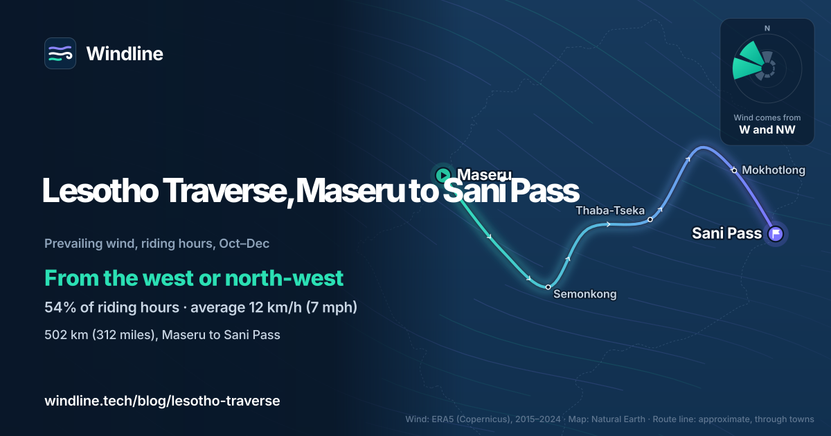
- Maseru to Semonkong: into the countryside via the trading posts at Roma and Ramambanta, then high into the mountains and a gentle descent to Semonkong, near Maletsunyane Falls.
- Semonkong to Thaba-Tseka: a short stretch shared with the Dragon's Spine route, then over ridges and along river-valley dirt tracks.
- Thaba-Tseka to Mokhotlong: deep into the mountains. There's little food on the way, so carry a couple of days' worth.
- Mokhotlong to Sani Pass: the final climb, then the descent into KwaZulu-Natal, with views of the Drakensberg.
Want this for your own route? Windline shows the wind for every stretch, timed to your pace. Free. Make a free ride page →
What's the weather like through the year?
Spring starts drier and ends wet, and it's the windiest, gustiest part of the year.
Weather across the year on the Lesotho Traverse, 2015–2024
| Month | Wind from | Average wind, km/h (mph) | Gusty days | Start → high, °C (°F) | Wet days |
|---|---|---|---|---|---|
| Jan | W, NW | 9 (5) | 7% | 17° (63°) → 23° (74°) | 65% |
| Feb | W, NW | 8 (5) | 6% | 16° (61°) → 23° (73°) | 58% |
| Mar | W, NW | 9 (5) | 6% | 14° (58°) → 22° (71°) | 52% |
| Apr | W, NW | 9 (5) | 9% | 10° (50°) → 19° (66°) | 38% |
| May | W, NW | 8 (5) | 6% | 5° (41°) → 17° (63°) | 15% |
| Jun | NW, W | 8 (5) | 10% | 1° (34°) → 14° (58°) | 7% |
| Jul | NW, W | 9 (5) | 15% | 1° (33°) → 14° (57°) | 10% |
| Aug | NW, W | 11 (7) | 25% | 5° (40°) → 16° (62°) | 13% |
| Sep | NW, W | 12 (8) | 34% | 11° (51°) → 20° (68°) | 23% |
| Oct | W, NW | 12 (7) | 28% | 14° (58°) → 21° (70°) | 39% |
| Nov | W, NW | 12 (8) | 33% | 16° (61°) → 22° (72°) | 54% |
| Dec | W, NW | 11 (7) | 24% | 18° (64°) → 23° (74°) | 66% |
From October to December, the wind came mostly from the west or north-west at 11–12 km/h (7–8 mph), and 24–33% of days were gusty. Rain builds through the season: 39% of October days were wet, 66% of December's. Mornings started at 14–18°C (58–64°F) and warmed to 21–23°C (70–74°F).
Which way should you ride it?
From Maseru to Sani Pass, as published: in past springs the wind was usually behind you. Riding west to east, a westerly helps on most legs, and a north-westerly is behind you on the last one, south-east from Mokhotlong.
In our October–December riding hours for 2015–2024, the wind came from the west or north-west 54% of the time. Westerly winds (south-west, west and north-west) made up 62% of hours, easterly ones just 8%, and 15% were calm. The average was 12 km/h (7 mph).
These are past averages, not a forecast, and mountain valleys bend the wind. On a gusty day, a side-on gust on an exposed ridge matters more than the average (see how windy is too windy to cycle).
How do you get there and back?
Maseru has an airport and regular buses from Bloemfontein. From Sani Pass, the makers suggest carrying on to Durban, which has an airport and plenty of buses.
- Borders: all visitors to Lesotho travel through South Africa, so you'll cross two borders each way. The UK asks British travellers for at least four blank passport pages.
- Sani Pass hours: its border posts usually open from 06:00 to 18:00, longer at holidays, so reach the top in good time.
- Travel advice: read your own government's advice for Lesotho and South Africa, such as the UK's Lesotho travel advice, before you book and again before you leave.
Like high, remote dirt roads? North America's Great Divide is the long version. For off-grid planning, see bikepacking weather.
Frequently asked questions
How hard is the Lesotho Traverse?
Hard on the legs, not on technique. BIKEPACKING.com rates it 7 out of 10, with very strenuous climbing: about 27 m per km (141 ft per mile). It says a few steep sections need some hiking, but most climbs are steady and the route isn't overly technical, with 97% of it rideable. Altitude adds to the effort, with a high point of 3,246 m (10,650 ft).
Can you ride the Lesotho Traverse in winter?
Only if you're ready for real cold. The route's makers say snow is common in the highlands from May to September, and winter nights there can fall to −18°C (0°F). In our 2015–2024 data, June mornings started at 1°C (34°F) and July's riding-hour highs averaged just 14°C (57°F), though June was also the driest month, with 7% wet days.
Where do you sleep on the Lesotho Traverse?
In trading posts, lodges or a tent. The route's makers recommend the trading posts at Roma and Ramambanta, and Semonkong Lodge. Elsewhere you can camp almost anywhere if you ask the local chief first; they say chiefs are usually happy to have guests. Village shops stock only basics, and Wi-Fi is rare outside the trading posts.
Is it safe to cycle across Lesotho?
Read your own government's travel advice for Lesotho and South Africa before you book, and again before you leave; the UK's Lesotho advice is one example. On the route itself, the makers' main warnings are the weather: summer thunderstorms are dangerous on the exposed highlands, and rain turns the roads to sticky mud. Leave your route and nightly stops with someone at home.
Get the wind for your ride.
Upload a GPX, add your start time and pace, and see the headwind, gusts, rain and heat for every stretch of the route, timed to when you’ll be there. Free for riders.
Make a free ride page →Sources and method
- BIKEPACKING.com (2026). The Lesotho Traverse
- UK Foreign, Commonwealth & Development Office (2026). Lesotho travel advice
- UK Foreign, Commonwealth & Development Office (2026). Lesotho travel advice: entry requirements
- Government of Lesotho (2018). Home Affairs extends working hours
- Government of Lesotho (2023). Ports of entry extend operating hours
- Wikipedia (2026). Lesotho–South Africa border (table of crossings and opening hours)
- Wikipedia (2026). Sani Pass
- Copernicus Climate Change Service (ECMWF) (2026). ERA5 hourly time-series data on single levels from 1940 to present
Route facts are from the route's page on BIKEPACKING.com (contributed by Logan Watts; the Maseru to Thaba-Tseka half was scouted by Darol Howes of the Lesotho Sky stage race), as read on 10 October 2026: length, eight days, 85% unpaved, 5% singletrack, 97% rideable, 13,442 m (44,100 ft) of climbing, a 3,246 m (10,650 ft) high point, difficulty 7 out of 10 and the October to December season. The climbing rate per km is our arithmetic (13,442 m ÷ 502 km, about 27 m per km), matching the page's 141 ft per mile. Entry rules are from the UK government's travel advice for British travellers; other nationalities should check their own. Sani Pass's usual border hours (06:00 to 18:00) are from the Government of Lesotho's notices on extended hours and the table of crossings on Wikipedia, which cites South Africa's Department of Home Affairs; hours change at holidays, so check before you go. Weather across the year: Windline's own analysis of hourly ERA5 reanalysis (Copernicus Climate Change Service, ECMWF), 1 January 2015 to 31 December 2024, downloaded from the Copernicus Climate Data Store, at three sample points along the route (Maseru, Thaba-Tseka and Sani Pass, nearest 0.25° grid cell), pooled. Riding hours are 08:00 to 17:00 local time. Wind is 10 m (33 ft) wind; the directions shown are the two commonest of eight compass sectors, and months when the hours barely agree on a direction are shown as changeable; hours under 5 km/h (3 mph) count as calm. A gusty day has a riding-hour gust of 50 km/h (31 mph) or more; a wet day has 1 mm or more of rain; start is the 08:00 temperature and high is the warmest riding hour. The direction figures use October to December riding hours only; westerly means the south-west, west and north-west sectors (62% of hours), easterly the north-east, east and south-east sectors (8%), and 15% were calm. Grid cells average over rough mountain ground, so valleys and ridges will differ. These are averages of past seasons, not forecasts. Contains modified Copernicus Climate Change Service information (ERA5, 2015–2024); neither the European Commission nor ECMWF is responsible for any use of this information. The map's route line joins towns in riding order; it is approximate and not the official GPX. Conversions use 1 mile = 1.609 km, 1 m = 3.281 ft and °F = °C × 1.8 + 32, rounded.
About the author
Wes Thomson, Founder, Windline. Wes Thomson builds Windline, live wind and weather forecasts timed to when riders reach each stretch of road. He built it for his own 2,093 km tour from Pont Drift to Cape Town, and writes these guides with the same focus: what the wind will do to your ride, and how to plan around it.