The Kenya Bike Odyssey: Nairobi to Nanyuki by bike
See how the Kenya Bike Odyssey loops through the Rift Valley, when to go, which way the wind blows and what to arrange first.
The short answer
The Kenya Bike Odyssey is a 1,024 km (636 mile) bikepacking route from Nairobi to Nanyuki, looping north past the Rift Valley lakes and then east across Laikipia. It's 80% unpaved and mostly above 1,700 m (5,500 ft). Allow at least three weeks, and ride in the dry months: June to October, or January and February.
Key takeaways
- Its makers list 18 days but suggest at least three weeks for the whole route.
- Bring a mountain bike with wide tubeless tyres, because acacia thorns are everywhere.
- In the best months, the riding-hour wind averaged just 6–10 km/h (4–6 mph).
- Some private land and Hell's Gate charge fees; arrange permission before you go.
- Read your own government's travel advice for Kenya before you book.
What is the Kenya Bike Odyssey?
The Kenya Bike Odyssey is a dirt-road route that loops north from Nairobi through the Rift Valley to Nanyuki, about 200 km (124 miles) north of the capital. Its makers scouted it for three months and published it on BIKEPACKING.com. It's one of our 10 most popular cycling tours in Africa, in our guide to the world's great cycling routes.
| The route at a glance | |
|---|---|
| Length | 1,024 km (636 miles), Nairobi to Nanyuki |
| Country | Kenya: the Rift Valley and Laikipia |
| Usual days | 18 listed; the makers suggest at least three weeks |
| Surface | 80% unpaved, 5% singletrack |
| Climbing | 14,339 m (47,045 ft); high point 2,716 m (8,912 ft) |
| Signage | Ride from the route's published GPX file |
| Best months | June to October, and January to February |
Which sections do people ride?
The trail notes give 17 days, plus an optional 18th towards Nyeri, in five stretches.
- Nairobi to Lake Naivasha (days 1–3): across Kedong Ranch, then through Hell's Gate National Park among the wildlife.
- Eburru Forest to Menengai Crater (days 4–5): past Lake Elementaita.
- The Kerio ridgeline (days 6–8): Mogotio, Tenges and Katimok Forest, along the ridge between the Kerio and Rift Valleys.
- Lakes Baringo and Bogoria (days 9–11): keep clear of the shore, where crocodiles and hippos live.
- Nyahururu and Laikipia to Nanyuki (days 12–17): savannah and conservancies, where buffaloes and elephants are common.
Kedong Ranch, Eburru Forest and several Laikipia stretches need permission, usually by phoning ahead, and a small fee.
Want this for your own route? Windline shows the wind for every stretch, timed to your pace. Free. Make a free ride page →
What's the weather like through the year?
The wind is light all year, so rain decides when you go.
Weather across the year on the Kenya Bike Odyssey, 2015–2024
| Month | Wind from | Average wind, km/h (mph) | Gusty days | Start → high, °C (°F) | Wet days |
|---|---|---|---|---|---|
| Jan | NE, N | 9 (6) | 2% | 18° (64°) → 28° (82°) | 19% |
| Feb | NE, N | 10 (6) | 5% | 18° (64°) → 29° (84°) | 18% |
| Mar | NE, E | 9 (6) | 4% | 19° (66°) → 29° (85°) | 30% |
| Apr | E, NE | 8 (5) | 1% | 19° (67°) → 27° (81°) | 70% |
| May | E, SE | 7 (4) | 0% | 19° (65°) → 26° (78°) | 53% |
| Jun | ~Changeable | 7 (4) | 0% | 17° (63°) → 25° (77°) | 32% |
| Jul | SE, S | 6 (4) | 0% | 17° (62°) → 24° (76°) | 37% |
| Aug | SE, E | 7 (4) | 0% | 17° (62°) → 25° (77°) | 33% |
| Sep | E, SE | 7 (4) | 0% | 18° (64°) → 26° (79°) | 30% |
| Oct | E, SE | 8 (5) | 0% | 19° (66°) → 27° (81°) | 45% |
| Nov | E, NE | 8 (5) | 1% | 19° (66°) → 26° (78°) | 62% |
| Dec | NE, E | 9 (6) | 3% | 18° (65°) → 27° (80°) | 32% |
In the best months, the average riding-hour wind was 6–10 km/h (4–6 mph), and June to October had no gusty days at all. January and February were the driest, with 18–19% wet days, and the warmest, reaching 28–29°C (82–84°F). From June to October, 30–45% of days were wet, against 70% in April. Mornings started at 17–19°C (62–66°F).
Which way should you ride it?
Ride it as published, Nairobi to Nanyuki: the wind is too light to change your plans, and the trail notes run in that order.
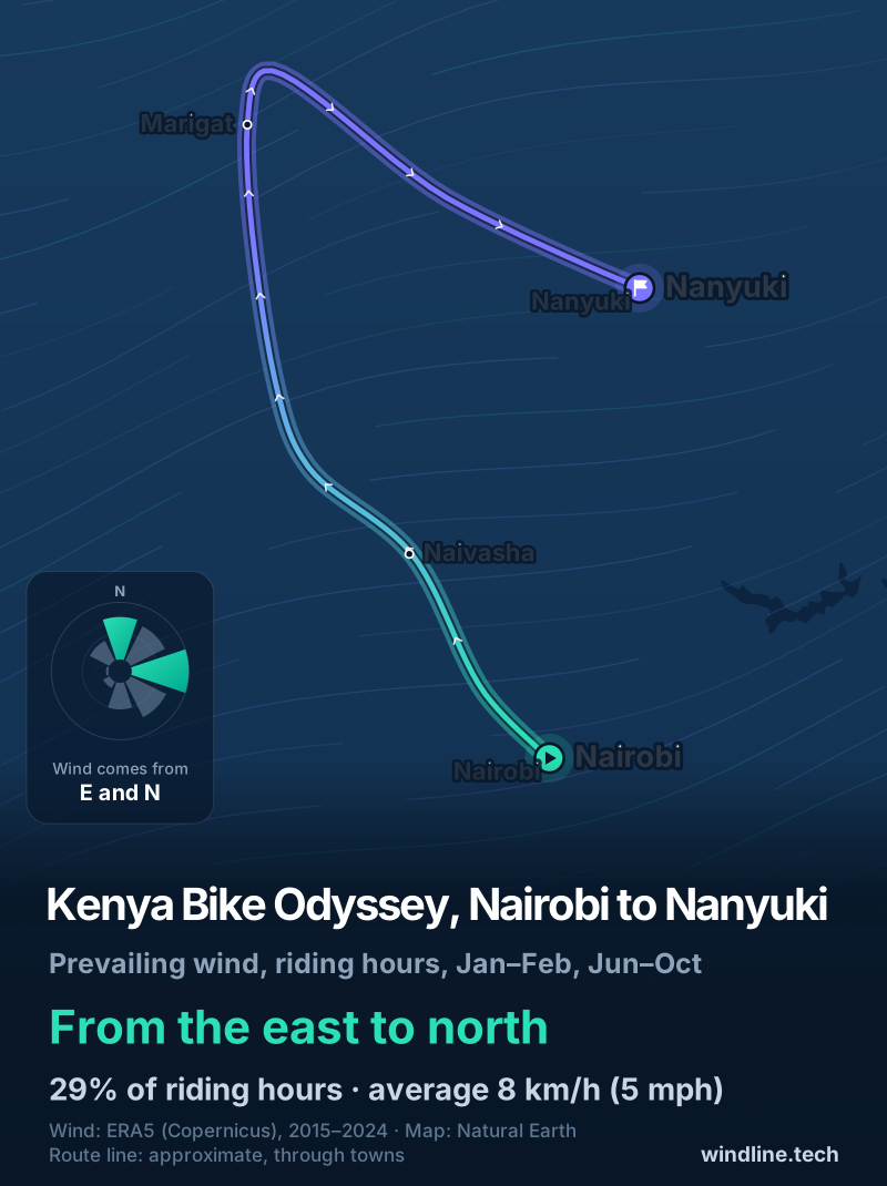
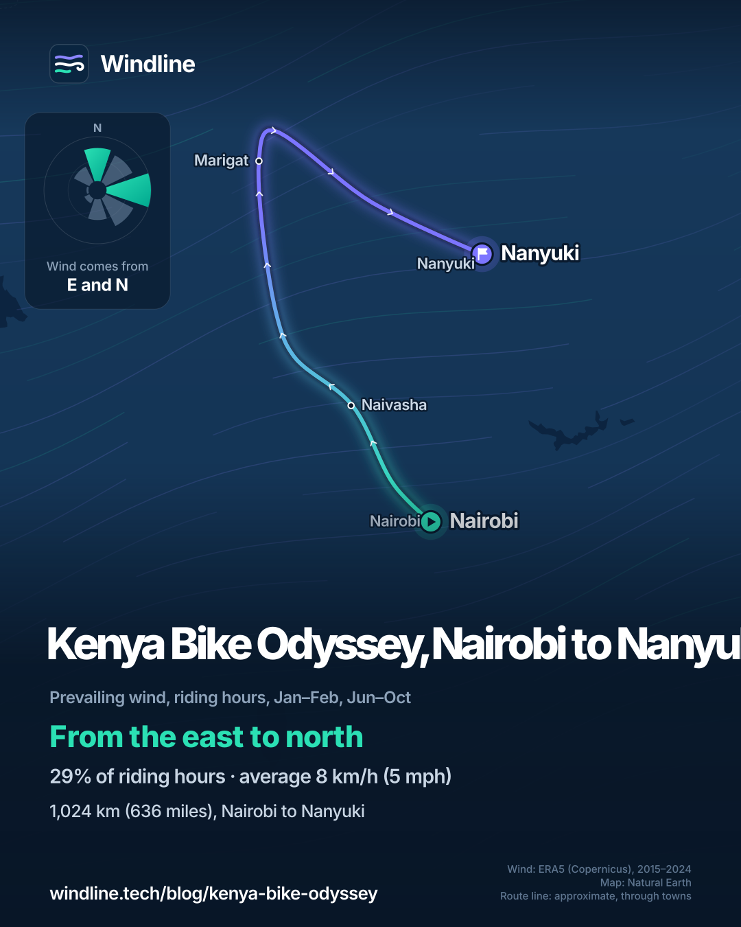
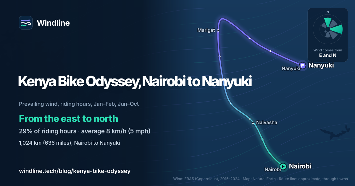
In our riding hours for the best months, 2015–2024, the wind came from the east or north 29% of the time. Easterly winds (north-east, east and south-east) made up 40% of hours, westerly ones 9%, and 31% were calm. The average was 8 km/h (5 mph). January and February leaned north-east, July to October south-east and east, and June was changeable in direction.
The route heads north-west, then north to Lake Baringo, then east to Nanyuki. So south-easterlies help on the way north, and easterlies meet you on the last leg. These are averages of past seasons, not a forecast (see how much a headwind slows you down).
What do you need to know before you go?
Start with travel advice, then water.
- Travel advice: read your own government's travel advice for Kenya before you book. The UK's, for example, tells British visitors to apply online for an Electronic Travel Authorisation before travelling, at least two weeks ahead.
- Getting there and back: Nairobi has an international airport. From Nanyuki, buses and taxis run back to Nairobi, or your bike can ride on a matatu's (minibus's) roof.
- Water and food: carry 3–4 litres (0.8–1.1 US gallons) and a filter or purification. Shops are frequent, so 1–2 days of food is plenty. See our food and water guide.
- Weather: save each forecast while you have signal (see bikepacking weather).
For a longer dirt epic in the same months, try North America's Great Divide.
Frequently asked questions
Is the Kenya Bike Odyssey safe to ride?
Read your own government's travel advice for Kenya before you book and again before you leave, because it changes. On the route, its makers say the biggest dangers are buffaloes and elephants, common in the north-east, and crocodiles or hippos near the lakes. With common sense, awareness and caution, they say, there's generally nothing to worry about.
Can you ride the Kenya Bike Odyssey on a gravel bike?
Its makers strongly recommend a mountain bike. They suggest 29 x 2.6 in tyres, or 2.2–2.4 in mountain bike tyres, set up tubeless because acacia thorns are abundant. With 14,339 m (47,045 ft) of climbing, some singletrack and a high point of 2,716 m (8,912 ft), low gears matter as much as the tyres.
Do you need permission to cross private land?
Yes, on several stretches, and you must arrange it in advance. The landowners have agreed to let riders on the route pass for a small fee, and the trail notes give each contact and price. Hell's Gate National Park charges its own entry fee. Mobile signal is generally very good, so paying by M-Pesa is easy even in remote areas.
Can you wild camp on the Kenya Bike Odyssey?
Not in Laikipia, its makers advise. Elephants could walk over a tent at night, and lions, leopards and hyenas live there too. Each day in the trail notes ends with places to stay, and most lodges will let you camp outside for less if you ask. For camping rules elsewhere, see our [wild camping guide](/blog/wild-camping-rules-by-country/).
Get the wind for your ride.
Upload a GPX, add your start time and pace, and see the headwind, gusts, rain and heat for every stretch of the route, timed to when you’ll be there. Free for riders.
Make a free ride page →Sources and method
- BIKEPACKING.com (2026). Kenya Bike Odyssey
- UK Foreign, Commonwealth & Development Office (2026). Kenya travel advice: entry requirements
- UK Foreign, Commonwealth & Development Office (2026). Foreign travel advice
- Copernicus Climate Change Service (ECMWF) (2026). ERA5 hourly time-series data on single levels from 1940 to present
Route facts are from the route's page on BIKEPACKING.com, published by its makers, and entry rules from the UK government's travel advice for Kenya, both read on 10 October 2026. Length, days, the share unpaved and singletrack, climbing, high point and best months are the makers' own figures, as in our Africa list; the 18 days are 17 main days plus an optional 18th, and the makers suggest at least three weeks. The day groupings in the sections are ours, from the makers' day headings. Weather across the year: Windline's own analysis of hourly ERA5 reanalysis (Copernicus Climate Change Service, ECMWF), 1 January 2015 to 31 December 2024, downloaded from the Copernicus Climate Data Store, at three sample points along the route (Nairobi, Marigat and Nanyuki, nearest 0.25° grid cell), pooled. Riding hours are 08:00 to 17:00 local time. Wind is 10 m (33 ft) wind; the directions shown are the two commonest of eight compass sectors, and months when the hours barely agree on a direction are shown as changeable; hours under 5 km/h (3 mph) count as calm. A gusty day has a riding-hour gust of 50 km/h (31 mph) or more; a wet day has 1 mm or more of rain; start is the 08:00 temperature and high is the warmest riding hour. Grid cells average out the terrain, so the highest climbs run cooler than these figures. The direction figures use riding hours in the makers' best months only (January–February and June–October); easterly means the north-east, east and south-east sectors, westerly the south-west, west and north-west sectors. These are averages of past seasons, not forecasts. Contains modified Copernicus Climate Change Service information (ERA5, 2015–2024); neither the European Commission nor ECMWF is responsible for any use of this information. The map's route line joins towns in riding order (coordinates from Wikipedia); it is approximate and not an official route map. Conversions use 1 mile = 1.609 km, 1 m = 3.281 ft, 1 US gallon = 3.785 litres and °F = °C × 1.8 + 32, rounded.
About the author
Wes Thomson, Founder, Windline. Wes Thomson builds Windline, live wind and weather forecasts timed to when riders reach each stretch of road. He built it for his own 2,093 km tour from Pont Drift to Cape Town, and writes these guides with the same focus: what the wind will do to your ride, and how to plan around it.