Cycling around Mauritius: the coastal loop, trade wind and best months
Plan the 253 km ride round Mauritius with the weather for every month, where the trade wind hits and what to know about the roads.
The short answer
Cycling around Mauritius on the coast roads is a loop of about 253 km (157 miles) with 1,629 m (5,345 ft) of climbing, mapped in seven stages. Ride in the Mauritius Meteorological Services' winter, May to October. The east to south-east trade wind blows along the south and north-east coasts, so one of them is always into it.
Key takeaways
- The mapped coastal loop is 253 km (157 miles), in seven stages of 27–48 km.
- Ride in winter, May to October, when it's cooler and drier.
- Neither direction wins on wind; the south coast and the north-east take it hardest.
- Traffic keeps left, and 4 cyclists died on Mauritius's roads in 2025.
What does cycling around Mauritius involve?
Cycling around Mauritius means the loop local riders call the tour de l'île: the coast roads all the way round the island, about 253 km (157 miles). The island is only about 45 km (28 miles) across, so the whole coast fits in a short trip. It's an island alternative to our 10 most popular cycling tours in Africa, and part of our guide to the world's great cycling routes.
| The route at a glance | |
|---|---|
| Length | About 253 km (157 miles), a loop |
| Country | Mauritius |
| Usual days | No official figure; mapped as seven stages, about 16 hours' riding |
| Surface | Mostly paved public roads (mapped for a road bike) |
| Climbing | 1,629 m (5,345 ft) |
| Signage | None; it isn't an official route |
| Best months | May to October (MMS winter) |
Which stretches do people ride?
Four coasts, each different. The mapped tour starts at Petite Rivière, south-west of Port Louis, and heads down the west coast first.
- West, Port Louis to Le Morne: Flic en Flac and Tamarin, on the island's sheltered side.
- South, Le Morne to Mahébourg: Bel Ombre and Souillac, the hilliest stretch. The tourism authority says the south is renowned for strong, steady trade winds.
- East, Mahébourg to Poste de Flacq: lagoons and Trou d'Eau Douce.
- North, Goodlands to Grand Baie and Port Louis: the flattest stages.
New to multi-day rides? Start with bikepacking for beginners; here you can sleep in guesthouses.
Want this for your own route? Windline shows the wind for every stretch, timed to your pace. Free. Make a free ride page →
What's the weather like through the year?
Winter, May to October, is cooler and drier but windier; summer is hot and wet.
Weather across the year on the Round Mauritius, 2015–2024
| Month | Wind from | Average wind, km/h (mph) | Gusty days | Start → high, °C (°F) | Wet days |
|---|---|---|---|---|---|
| Jan | E, SE | 20 (12) | 8% | 26° (79°) → 28° (82°) | 71% |
| Feb | E, SE | 20 (13) | 8% | 26° (79°) → 28° (82°) | 74% |
| Mar | E, SE | 20 (12) | 6% | 26° (79°) → 28° (82°) | 65% |
| Apr | E, SE | 22 (13) | 9% | 26° (78°) → 27° (81°) | 60% |
| May | SE, E | 23 (14) | 14% | 24° (75°) → 26° (78°) | 38% |
| Jun | SE, E | 27 (17) | 23% | 23° (73°) → 24° (75°) | 32% |
| Jul | SE, E | 27 (17) | 25% | 22° (71°) → 23° (74°) | 31% |
| Aug | E, SE | 25 (16) | 18% | 22° (71°) → 23° (74°) | 24% |
| Sep | E, SE | 25 (15) | 11% | 22° (71°) → 24° (75°) | 22% |
| Oct | E, SE | 21 (13) | 5% | 23° (74°) → 25° (77°) | 31% |
| Nov | E, SE | 19 (12) | 3% | 24° (76°) → 26° (79°) | 40% |
| Dec | E, SE | 19 (12) | 4% | 26° (78°) → 27° (81°) | 56% |
From May to October the riding-hour wind averaged 21–27 km/h (13–17 mph), strongest in June and July, when about a quarter of days were gusty. Mornings started at 22–24°C (72–75°F). September had the fewest wet days (22%), and October the lightest winter wind, with 5% of days gusty. From January to March, 65–74% of days were wet.
Which way round should you ride?
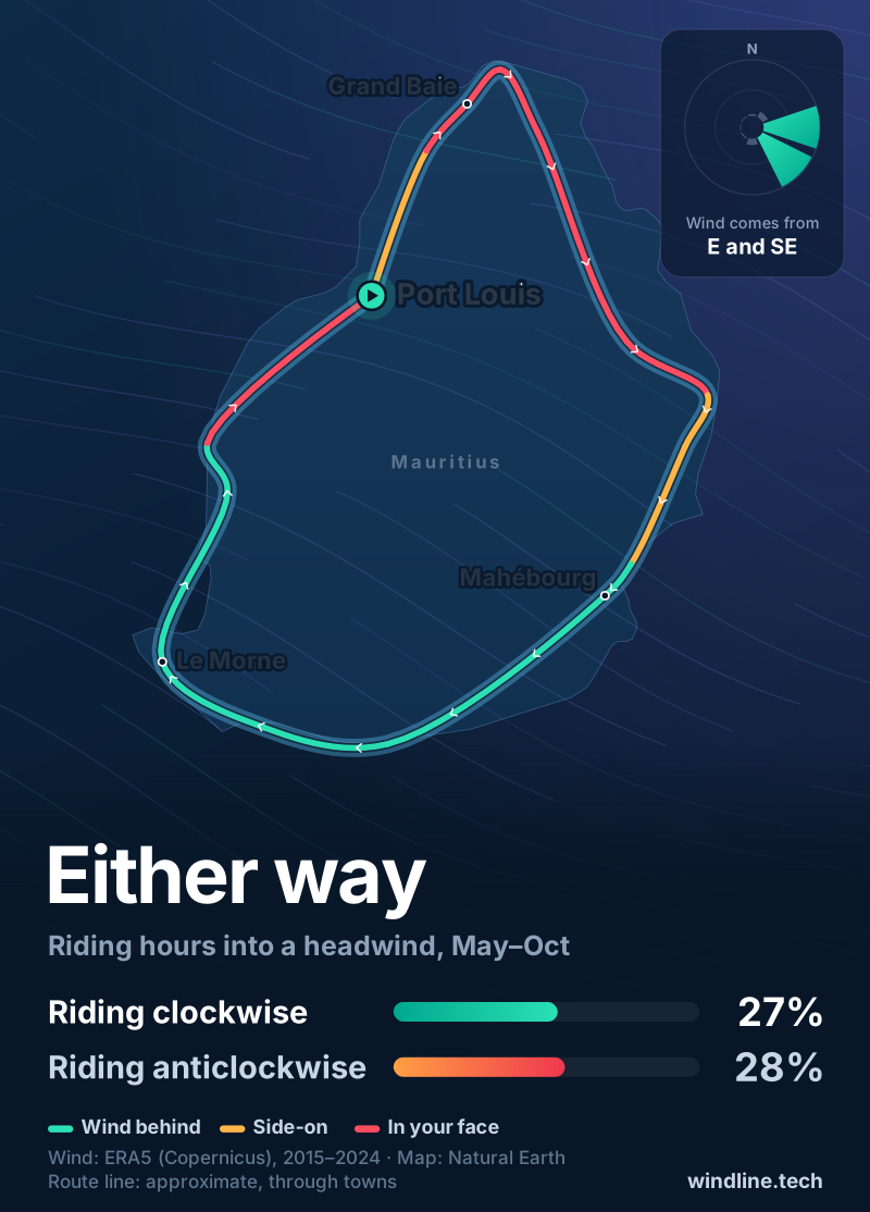
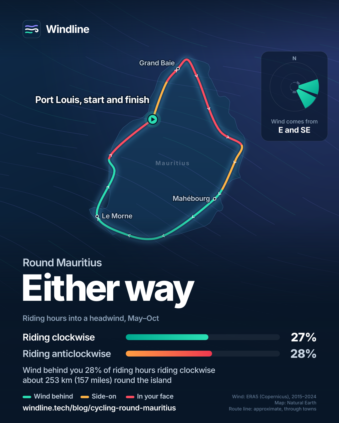
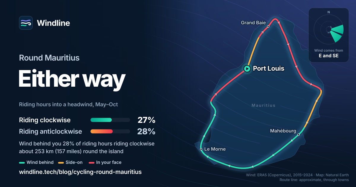
Either way: on wind alone it's a draw. In May-to-October riding hours, anticlockwise riders met a headwind 28% of the time, clockwise riders 27%.
The trade wind came from the east or south-east in 86% of riding hours, averaging 25 km/h (15 mph). Direction only changes where you meet it.
- Anticlockwise: headwinds in 89–92% of hours from Le Morne to Souillac, then a tailwind 69–93% of the time from Trou d'Eau Douce to Cap Malheureux.
- Clockwise: the reverse, with the headwind up the north-east.
- East and west coasts: mostly side-on either way.
So ride the exposed coast on fresh legs. MMS warns that in July and August strong high-pressure systems can bring winds around 40 km/h (25 mph), gusting above 90 km/h (56 mph) in exposed areas. These are averages of past seasons, not a forecast; a headwind costs more than a tailwind gives back.
What should you know before you go?
The roads are busy, so ride defensively and check the weather service daily.
- Traffic: 746,961 vehicles were registered at the end of 2025. That year 62 cyclists were killed or injured, 4 of them killed (Statistics Mauritius, provisional).
- Driving side: left, giving way to the right.
- Cyclones: MMS issues four warning classes; from Class III, avoid going outside. Weather line 171, cyclone reports 96.
- Heat: January and February are warmest, MMS says, with average daytime highs of 29°C (84°F).
- Arriving: international flights land at Plaine Magnien, near Mahébourg.
Like island riding? See cycling in Mallorca.
Frequently asked questions
How long does it take to cycle round Mauritius?
The mapped loop is 253 km (157 miles) with 1,629 m (5,345 ft) of climbing, in seven stages of 27–48 km (17–30 miles) and about 16 hours of riding. At touring pace that's three or four days. It can be done in one: L'Express reported in 2025 on a Grand Baie rider who left at 3:40 am and was back before 11 pm.
Can you hire a bike in Mauritius?
Yes. The Mauritius Tourism Promotion Authority says many hotels rent bicycles or can point you to local hire companies. It suggests an e-bike for touring the island, for the extra stamina on harder roads. Bring your own helmet, lights and repair kit if you want kit you trust for several days on main roads.
Can you cycle round Mauritius in summer?
You can, but it's wetter and hotter. From January to March, 65–74% of days were wet in our data, and the warmest riding hour averaged 28°C (82°F). Watch for cyclone warnings too. Mauritius Meteorological Services issues four classes, and from Class III it advises people to avoid going outside.
Get the wind for your ride.
Upload a GPX, add your start time and pace, and see the headwind, gusts, rain and heat for every stretch of the route, timed to when you’ll be there. Free for riders.
Make a free ride page →Sources and method
- Bikemap (2026). Maurice circumnavigation by road bike (seven-stage tour)
- L'Express (Port Louis), via allAfrica (2025). Ile Maurice: Il boucle le tour de l'île en moins de 24 heures
- Mauritius Meteorological Services (2026). Climate of Mauritius
- Mauritius Meteorological Services (2026). Seasonal climate forecast (Winter 2026 Outlook)
- Mauritius Meteorological Services (2026). Tropical cyclone warning system
- Mauritius Meteorological Services (2026). Cyclone precautions
- Statistics Mauritius (2026). Road Transport and Road Traffic Accident Statistics (Island of Mauritius), Year 2025
- Mauritius Tourism Promotion Authority (2026). Getting around Mauritius
- Mauritius Tourism Promotion Authority (2026). Useful tips
- Mauritius Tourism Promotion Authority (2026). Mauritius island
- Mauritius Tourism Promotion Authority (2026). South coast of Mauritius
- Copernicus Climate Change Service (ECMWF) (2026). ERA5 hourly time-series data on single levels from 1940 to present
- Copernicus Climate Change Service (ECMWF) (2026). ERA5 hourly data on single levels from 1940 to present
- Natural Earth (2026). Terms of use (public domain map data)
There is no official round-island cycle route in Mauritius. The length, climbing and stages are from the seven-stage "Maurice circumnavigation by road bike" tour on Bikemap (253 km, 1,629 m of ascent, stages of 26.5–47.9 km, starting and finishing at Petite Rivière, west of Port Louis, and running south down the west coast first), read on 11 October 2026. The one-day ride is from L'Express (Port Louis), 24 September 2025, via allAfrica. Best months are the Winter 2026 Outlook of Mauritius Meteorological Services (MMS), which defines winter as 1 May to 31 October; MMS's Climate of Mauritius page gives June to September as the cool, dry season, May and October as transition months, and October as the driest month. Trade wind direction and strength in winter, and the July–August strong-wind episodes, are from the same outlook. Cyclone warning classes and precautions are from MMS; we found no cyclone-season dates on an MMS page, so the article gives none. Road deaths and casualties are Statistics Mauritius's provisional 2025 figures. Driving side, bike hire, the airport and the weather phone lines are from the Mauritius Tourism Promotion Authority's visitor site. Weather across the year: Windline's own analysis of hourly ERA5 reanalysis (Copernicus Climate Change Service, ECMWF), 1 January 2015 to 31 December 2024, downloaded from the Copernicus Climate Data Store, at four sample points round the island (Grand Baie, Mahébourg, Le Morne and Flic en Flac, nearest 0.25° grid cell), pooling hours and days across the points. Riding hours are 08:00 to 17:00 local time. Wind is 10 m (33 ft) wind; directions are the commonest two of eight compass sectors; hours under 5 km/h (3 mph) count as calm. A gusty day has a riding-hour gust of 50 km/h (31 mph) or more; a wet day has 1 mm or more of rain; start is the 08:00 temperature and high is the warmest riding hour. The prevailing wind is for May to October riding hours. Which way round: the loop was drawn through 15 coastal towns from Port Louis (anticlockwise: Flic en Flac, Tamarin, Le Morne, Bel Ombre, Souillac, Mahébourg, Vieux Grand Port, Grand River South East, Trou d'Eau Douce, Centre de Flacq, Goodlands, Cap Malheureux, Grand Baie, Trou-aux-Biches) and each straight leg scored against its own grid cell's May-to-October riding-hour wind: a headwind hour has the wind within 60° of straight ahead, a tailwind hour within 60° of straight behind, the rest are side-on, and hours under 6 km/h count as calm. Shares for the whole loop are weighted by leg length; clockwise is the same legs reversed. The legs are straight lines between towns, shorter than the road, so they show where the wind hits, not exact distances. This is our reading, not an official recommendation, and these are averages of past seasons, not forecasts. ERA5 cells are about 25–30 km (16–19 miles) across, so they cannot see shelter from hills, buildings or trees. Contains modified Copernicus Climate Change Service information (ERA5, 2015–2024); neither the European Commission nor ECMWF is responsible for any use of this information. The map's route line joins coastal towns in riding order; it is approximate and not an official route. Basemap from Natural Earth (public domain). Conversions use 1 mile = 1.609 km, 1 m = 3.281 ft, 1 km/h = 0.621 mph and °F = °C × 1.8 + 32, rounded.
About the author
Wes Thomson, Founder, Windline. Wes Thomson builds Windline, live wind and weather forecasts timed to when riders reach each stretch of road. He built it for his own 2,093 km tour from Pont Drift to Cape Town, and writes these guides with the same focus: what the wind will do to your ride, and how to plan around it.