Cycling Iceland's Ring Road: clockwise or anticlockwise?
See what ten summers of hourly wind data say about riding Route 1 clockwise or anticlockwise, month by month and stretch by stretch.
The short answer
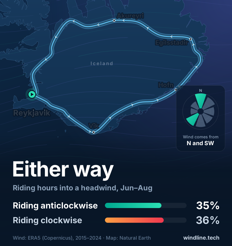
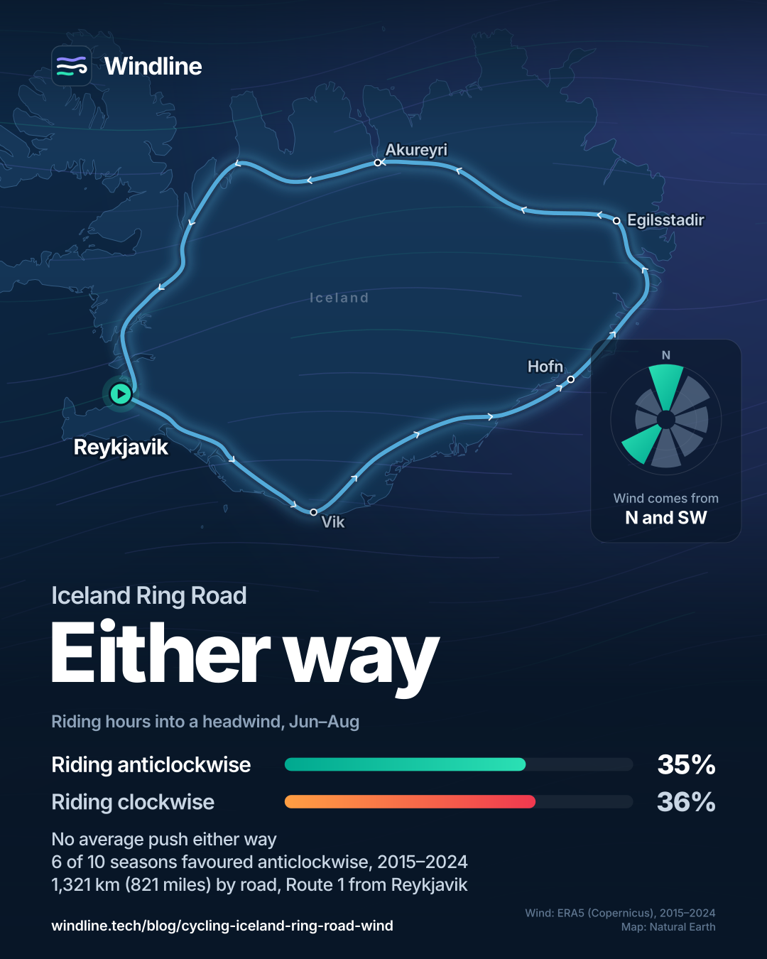
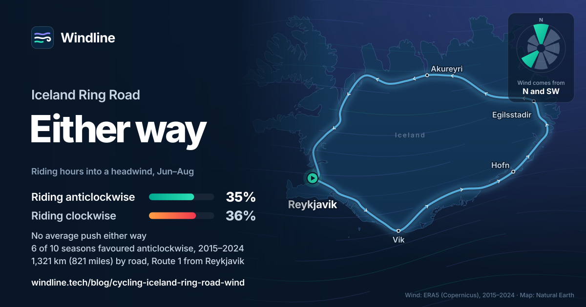
Neither direction has a real wind advantage for cycling Iceland's Ring Road. Over ten summers (June to August, 2015–2024), clockwise riders met a headwind in 36% of daytime riding hours and anticlockwise riders in 35%, with no average push either way. The weather in your own fortnight decides it, so choose from the forecast.
Key takeaways
- Over ten summers, clockwise and anticlockwise met headwinds in 36.0% and 34.6% of riding hours: a draw.
- No direction dominates; the most common, north, blew in only 14.6% of summer riding hours.
- Only the west, Reykjavík to Blönduós, leans one way, and it favours riding anticlockwise.
- In any one fortnight, one direction can be 5 km/h (3 mph) better, so decide from the forecast.
- Safetravel asks riders to think twice about Route 1 because of heavy summer traffic.
Definitions
- Along-route wind
- The part of the wind blowing straight along your direction of travel; against you it's a headwind, behind you a tailwind.
- Headwind hour
- A riding hour in which the wind along the route was more than 4 km/h (2.5 mph) against you.
- ERA5 reanalysis
- A record of past weather that blends observations from around the world with a weather model to fill in every hour and place.
Cycling Iceland's Ring Road clockwise or anticlockwise: which way has the better wind?
Neither. We took ten years of hourly wind along Route 1, from Reykjavík and back, and scored every June-to-August riding hour in both directions. The method, and other famous routes, are in our hub on prevailing winds on the world's great cycling routes.
| Direction, June to August | Average wind along the route, km/h (mph) | Headwind hours | Tailwind hours | Strong headwind hours, over 15 km/h (9 mph) | Modelled riding time vs still air |
|---|---|---|---|---|---|
| Clockwise (north first) | 0.0 (0.0) | 36.0% | 34.6% | 8.9% | 2.2% slower |
| Anticlockwise (south coast first) | 0.0 (0.0) | 34.6% | 36.0% | 9.3% | 2.3% slower |
The other 29.4% of hours were side-on or calm. Both directions are slower than still air, because a headwind costs more than a tailwind gives back.
Why doesn't one direction win on a loop?
A loop turns through every compass point, so a steady wind is behind you on one side of the island and against you on the other. Only wind that changes from place to place can favour one direction.
Iceland's summer wind has no single habit. The most common direction along the route was north, in just 14.6% of riding hours, then south-west (12.9%), north-east (12.6%) and south (12.3%).
Compare Britain, where a westerly habit favoured riding LEJOG northbound in all ten seasons.
Want this for your own route? Windline shows the wind for every stretch, timed to your pace. Free. Make a free ride page →
Which summer months favour which direction?
None by much. June leans very slightly clockwise; July and August very slightly anticlockwise.
| Month | Clockwise wind along the route, km/h (mph) | Headwind hours, clockwise / anticlockwise | Modelled time, clockwise / anticlockwise |
|---|---|---|---|
| June | 0.3 (0.2) tailwind | 36.3% / 37.1% | +2.1% / +3.1% |
| July | 0.1 (0.1) headwind | 36.2% / 33.8% | +2.3% / +1.9% |
| August | 0.1 (0.1) headwind | 35.4% / 33.0% | +2.3% / +1.9% |
The years agree. Clockwise riders averaged a small headwind in six summers from 2015 to 2024, a small tailwind in three, and neither in 2020. No summer moved the average more than 0.4 km/h (0.2 mph).
Where on the Ring Road does the direction matter?
In the west, between Reykjavík and Blönduós. It's the only stretch with a clear lean, and it favours anticlockwise.
| Section, June to August | Length, km (miles) | Clockwise wind, km/h (mph) | Headwind hours, clockwise / anticlockwise | Modelled time, clockwise / anticlockwise |
|---|---|---|---|---|
| West: Reykjavík to Blönduós | 203 (126) | 2.8 (1.7) headwind | 50.0% / 30.7% | +7.6% / −1.3% |
| North: Blönduós to Mývatn | 158 (98) | 0.6 (0.4) tailwind | 25.1% / 30.6% | −0.1% / +1.8% |
| East: Mývatn to Djúpivogur | 204 (127) | 0.8 (0.5) tailwind | 35.9% / 38.0% | +0.9% / +3.7% |
| South coast to Reykjavík | 439 (273) | 0.7 (0.4) tailwind | 33.4% / 36.3% | +1.2% / +3.5% |
Near Blönduós, the wind came from the north in 39% of riding hours and the north-east in 18%, averaging 14.4 km/h (8.9 mph). In our rider model, the west costs clockwise riders about 45 minutes; the rest of the loop hands almost exactly that back.
Where are the strongest winds and gusts on Route 1?
On the south-east coast, the east fjords and the high ground east of Mývatn, where the windiest grid cells averaged 15–18 km/h (9–11 mph).
- Just east of Höfn: 17.6 km/h (10.9 mph), most often south-westerly.
- Mýrdalssandur, the sand plain east of Vík: 16.6 km/h (10.3 mph), most often easterly.
- Around Möðrudalur, between Mývatn and Egilsstaðir: 16.0–16.3 km/h (9.9–10.1 mph).
- Breiðdalsvík, in the east fjords: 15.2 km/h (9.4 mph).
Gusts are the real danger. A 2012 study by Iceland's Road Administration mapped 67 places on busy roads where strong gusts are common, usually near steep mountains and often under 3 km (2 miles) of road. It notes gusts there can exceed 50 m/s, 180 km/h (112 mph). A 31 km (19-mile) grid cell can't see places that small, so treat fjords and mountain-foot stretches as exposed.
Our verdict: should you ride clockwise or anticlockwise?
On ten years of averages, it's a coin toss. Ride whichever way suits your flights or the sights you want first.
Your own fortnight is different. We rode the line in 14 equal days, both ways, from all 920 June-to-August start dates in 2015–2024. Clockwise had the better wind on 50.1% of them. But on one start date in ten, anticlockwise won by at least 5.7 km/h (3.5 mph) of trip-average headwind, and on another one in ten clockwise won by 5.2 km/h (3.2 mph) or more.
So decide late, from the forecast for your first few days. If you can't, anticlockwise saves the west for the end.
What else should decide how you ride the Ring Road?
Traffic matters more than wind. Safetravel, run by the Icelandic Association for Search and Rescue (ICE-SAR), asks anyone considering Route 1 by bike to think twice.
- Traffic. Summer traffic is very heavy, and shoulders are often narrow or missing.
- Being seen. It recommends powerful lights, including a strong rear light, and high-visibility clothing.
- Weather. It can change dramatically within a day, with snow possible even in midsummer.
- Travel plan. Leave one at Safetravel, with an emergency contact who isn't travelling with you.
How should you plan around the wind for your dates?
Treat the averages as a draw, then let the forecast decide.
- Leave spare days, so one storm doesn't break the plan: see planning a multi-day tour.
- Check official warnings every morning: the Icelandic Met Office's colour-coded alerts at en.vedur.is, and road conditions and weather from the Road and Coastal Administration at umferdin.is (traffic service: 1777). They always come first; how windy is too windy to cycle gives general limits.
- Read each day's forecast against the road: reading a forecast for a bike ride explains why.
Frequently asked questions
How much time does the wind add to riding the Ring Road?
Not much, and the same either way. Our model touring rider does 24.1 km/h (15.0 mph) in still air, so Route 1's 1,321 km (821 miles) is about 54.8 hours of pedalling. June-to-August wind made that 2.2% slower clockwise and 2.3% anticlockwise: about an hour and a quarter.
Does the wind in Iceland blow mostly from the east?
Not in summer riding hours. Along the Ring Road, east was only the fifth most common direction, at 10.4% of hours; north led with 14.6%. Some places do have a habit: near Vík the wind came most often from the east, and near Blönduós from the north.
Where is the calmest part of the Ring Road?
Around Akureyri. The grid cell nearest the town averaged 7.4 km/h (4.6 mph) in June-to-August riding hours, and 28% of them were calm, under 5 km/h (3 mph). The cell by Skaftafell was similar: 7.7 km/h (4.8 mph) and 30.6% calm. The windiest cells averaged more than twice that.
Can I trust reanalysis wind data for a ride in Iceland?
For "which way usually wins", yes; for a single day, no. ERA5 averages wind over grid cells about 31 km (19 miles) across, at 10 m (33 ft) above ground. Iceland's worst gusts hit short stretches of road under steep mountains, far smaller than a cell. Plan with the averages; ride with official forecasts.
Does riding in May or September change the answer?
Barely. In May, clockwise riders averaged a 0.5 km/h (0.3 mph) tailwind and met headwinds in 35.7% of riding hours, against 37.6% anticlockwise. September was a draw, at 36.6% and 36.3%. Safetravel warns that snow is possible even in midsummer, so shoulder months need more spare days.
Get the wind for your ride.
Upload a GPX, add your start time and pace, and see the headwind, gusts, rain and heat for every stretch of the route, timed to when you’ll be there. Free for riders.
Make a free ride page →Sources and method
- Copernicus Climate Change Service (ECMWF) (2026). ERA5 hourly time-series data on single levels from 1940 to present
- Quarterly Journal of the Royal Meteorological Society (2020). The ERA5 global reanalysis (Hersbach et al.)
- Copernicus Climate Change Service (ECMWF) (2026). ERA5 hourly data on single levels from 1940 to present
- ECMWF (2026). ERA5: data documentation (native resolution 31 km)
- Safetravel (Icelandic Association for Search and Rescue, ICE-SAR) (2026). Biking in Iceland
- Safetravel (Icelandic Association for Search and Rescue, ICE-SAR) (2026). Travel plans
- Icelandic Meteorological Office (2026). Alerts
- Icelandic Meteorological Office (2017). IMO impact-based colour-coded warnings on the web
- Icelandic Road and Coastal Administration (2026). Vegagerðin (road conditions and weather at umferdin.is; traffic service 1777)
- Icelandic Road Administration (Sveinbjörnsson, Jónasson and Jónsson), SIRWEC 2012 (2012). Wind gusts and local gust forecast for Icelandic roads
Windline's data desk took hourly 10 m wind (the u and v components, turned into speed and direction) from the Copernicus Climate Data Store, dataset ERA5 hourly time-series data on single levels (reanalysis-era5-single-levels-timeseries, doi:10.24381/1cf1ad76), for 1 January 2015 to 31 December 2024 (ten full years). ERA5 is described by Hersbach et al. (2020). The route is Route 1 as it runs today, a loop from Reykjavík through 28 towns and road points: Borgarnes (on the Hvalfjörður tunnel line), Holtavörðuheiði, Blönduós, Varmahlíð, Akureyri, Reykjahlíð at Mývatn, Möðrudalur, Egilsstaðir, the east-fjords line through Reyðarfjörður, Fáskrúðsfjörður and Breiðdalsvík, Djúpivogur, Höfn, Skaftafell, Kirkjubæjarklaustur, Vík, Hvolsvöllur and Selfoss. It measures 1,005 km (625 miles) point to point; Safetravel gives Route 1's length as 1,321 km (821 miles). It is not an official route. The line was cut into pieces of at most 25 km, and each piece takes its wind from the nearest ERA5 0.25° grid cell: every 0.25° grid cell along the route, 52 cells in all, so results are weighted by distance. ECMWF gives the model's native resolution as about 31 km, so these are area averages, not roadside readings. Riding hours are the values stamped 08:00 to 17:00 local time inclusive (Iceland keeps UTC all year). The riding season is June to August (months 6 to 8); the May and September figures use those calendar months. Clockwise means Reykjavík, north to Akureyri, east, then the south coast; anticlockwise is the reverse. For each hour and each piece, the along-route wind is the wind speed times the cosine of the angle between where the wind comes from and the direction of travel; riding the other way flips the sign. A headwind hour has more than 4 km/h (2.5 mph) against you, a tailwind hour more than 4 km/h behind you, and "strong" means more than 15 km/h (9 mph); the rest are side-on or calm. Side-on wind is the average size of the crosswind part. Wind direction shares count where the wind comes from in eight sectors, as a share of all riding hours; hours under 5 km/h (3 mph) count as calm. Sections are split at Blönduós, Reykjahlíð (Mývatn) and Djúpivogur. Figures for Blönduós and Akureyri are the ERA5 cell nearest each town (65.75° N 20.25° W and 65.75° N 18.0° W), computed the same way and also used in our bikepacking weather guide: Blönduós north 38.7%, north-east 18.0%, 14.4 km/h; Akureyri calm 27.6%, 7.4 km/h. Other places are the line's own grid cells: just east of Höfn 64.25° N 15.0° W; Mýrdalssandur, east of Vík, 63.5° N 18.5° W; around Möðrudalur 65.25° N 15.75° W and 65.5° N 16.0° W; Breiðdalsvík 64.75° N 14.0° W; Skaftafell 64.0° N 16.75° W; Vík 63.5° N 19.25° W. Year-to-year figures are the clockwise June-to-August average for each year (standard deviation 0.23 km/h). The trip test rides the whole line in 14 equal days in each direction, starting on every date from 1 June to 31 August in 2015 to 2024 (920 start dates), with each piece taking that day's average riding-hours wind; the two directions are compared from the same start date, and the 5.7 and 5.2 km/h figures are the 10th and 90th percentiles of the difference in trip-average headwind. Modelled riding time uses a steady-power touring rider: 100 kg (220 lb) of rider, bike and luggage, 120 W, rolling resistance 0.006, drag area 0.45 m², air density 1.2 kg/m³, which gives 24.1 km/h (15.0 mph) in still air. Wind at rider height is taken as 0.65 times the 10 m wind, and crosswind drag and terrain are ignored. The hours are our arithmetic: 1,321 km / 24.1 km/h = 54.8 hours, times 0.022 and 0.023 (1.2 and 1.3 hours). The West section: 203 km / 24.1 km/h = 8.42 hours, times 1.076 (9.06 hours) and 0.987 (8.31 hours), a gap of 0.75 hours; the other three sections give back 0.78 hours to clockwise riders (0.12 + 0.24 + 0.42). Every other figure is in results.json in the study's data folder. Imperial conversions use 1 mile = 1.609 km, 1 km/h = 0.621 mph and 1 m = 3.28 ft; 50 m/s = 180 km/h. Contains modified Copernicus Climate Change Service information (ERA5, 2015–2024); neither the European Commission nor ECMWF is responsible for any use of this information.
About the author
Wes Thomson, Founder, Windline. Wes Thomson builds Windline, live wind and weather forecasts timed to when riders reach each stretch of road. He built it for his own 2,093 km tour from Pont Drift to Cape Town, and writes these guides with the same focus: what the wind will do to your ride, and how to plan around it.