West Coast Wilderness Trail: sections, weather and the Totara Bridge
Split the trail into days, see its weather for every month, and plan around the closed Totara Bridge near Ross.
The short answer
The West Coast Wilderness Trail is a 133 km (83-mile) Great Ride from Greymouth to Ross on New Zealand's South Island, through rainforest, gold-rush relics and wetlands, with one climb to 317 m (1,040 ft). Most riders take four or five days. It's rideable all year, but expect rain on about half the days.
Key takeaways
- The Totara Bridge near Ross has been closed since August 2024, so check the trail alerts first.
- Kumara to Milltown, over the Kawhaka Pass, is the hardest section, with almost no phone coverage.
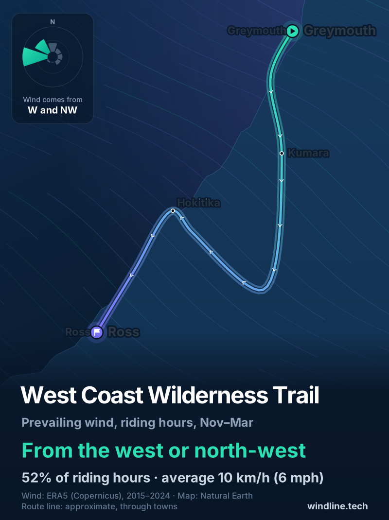
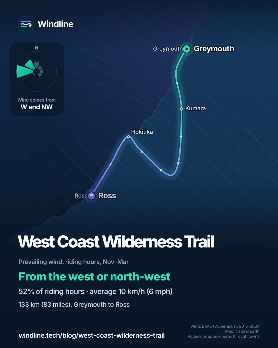
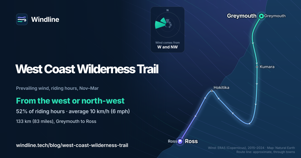
- From November to March, riding-hour winds came most often from the west or north-west, averaging 10 km/h (6 mph).
- In 2015–2024, 46–63% of days were wet in every month.
What is the West Coast Wilderness Trail?
It's one of New Zealand's 23 Great Rides: 133 km (83 miles) of mostly smooth gravel from Greymouth to Ross on the South Island's West Coast. It's one of our 10 most popular cycling tours in Australia and New Zealand, part of our guide to the world's great cycling routes.
| The trail at a glance | |
|---|---|
| Length | 133 km (83 miles), Greymouth to Ross |
| Country | New Zealand (West Coast, South Island) |
| Usual days | 4–5 (NZ Cycle Trail); the trail trust says 3–4 |
| Surface | Over 120 km (75 miles) off-road on gravel, plus quiet roads |
| Grade | 2 (easy), with some Grade 3 (intermediate) road sections |
| Signage | Well signposted; official map and the free Great Rides app |
| Best months | All year; December to March is busiest |
Which sections do people ride?
Most riders take four days, stopping at Kumara, Milltown or Lake Kaniere, and Hokitika. These are the trail trust's figures.
| Section | Length, km (miles) | Trust's time |
|---|---|---|
| Greymouth to Kumara | 28 (17) | 2–4 hours |
| Kumara to Milltown | 40 (25), or 50 (31) to Lake Kaniere | 3–6 hours |
| Milltown to Hokitika via Lake Kaniere | 31 (19), or 21 (13) from the lake | 3–5 hours |
| Hokitika to Ross | 33 (21) | 3–5 hours |
Day one is flat, along the coast and an old bush tramway. Day two climbs steadily to the Kawhaka Pass, 317 m (1,040 ft), with almost no phone coverage: the trust asks riders to be on this stretch by 9.30, and heavy rain can close it. Milltown is just a car park and shelter, so book a shuttle. The last day crosses the Mahinapua wetlands on narrow boardwalks without barriers.
Want this for your own route? Windline shows the wind for every stretch, timed to your pace. Free. Make a free ride page →
Is the whole trail open?
Not quite: as of 10 October 2026, the Totara Bridge just north of Ross is closed. Westland District Council shut it on 19 August 2024 over the risk of sudden failure, with no safe diversion.
The trust's alerts page says you can ride to the bridge from either side but not cross it. Heading south, you can finish on the Woodstock–Rimu Road or at the West Coast Treetop Walk, or ride on to Ross by road with extreme care; the trust doesn't encourage children to. The Government has funded a replacement of up to NZ$1.6 million, with no opening date published.
What's the weather like through the year?
Mild and wet: rain matters more than wind or heat.
Weather across the year on the West Coast Wilderness Trail, 2015–2024
| Month | Wind from | Average wind, km/h (mph) | Gusty days | Start → high, °C (°F) | Wet days |
|---|---|---|---|---|---|
| Jan | W, NW | 10 (6) | 14% | 14° (57°) → 19° (65°) | 54% |
| Feb | W, NW | 10 (6) | 15% | 13° (56°) → 19° (65°) | 47% |
| Mar | W, NW | 9 (5) | 10% | 12° (54°) → 18° (64°) | 49% |
| Apr | W, NW | 9 (5) | 13% | 11° (52°) → 15° (59°) | 48% |
| May | ~Changeable | 9 (5) | 16% | 9° (48°) → 13° (55°) | 55% |
| Jun | SE, E | 8 (5) | 11% | 7° (44°) → 11° (52°) | 46% |
| Jul | E, SE | 9 (5) | 13% | 6° (42°) → 10° (50°) | 52% |
| Aug | ~Changeable | 9 (5) | 12% | 6° (44°) → 11° (51°) | 59% |
| Sep | W, NW | 11 (7) | 22% | 8° (46°) → 12° (54°) | 57% |
| Oct | W, NW | 11 (7) | 17% | 9° (48°) → 13° (56°) | 63% |
| Nov | W, NW | 11 (7) | 20% | 11° (52°) → 15° (60°) | 60% |
| Dec | W, NW | 11 (7) | 16% | 13° (55°) → 17° (63°) | 58% |
In every month, 46–63% of days were wet, from June (46%) to October (63%), so pack for rain whatever the season (see what chance of rain means). Highs ran from 10°C (50°F) in July to 19°C (65°F) in January and February. Winds averaged only 8–11 km/h (5–7 mph); May and August were light and changeable in direction. Gusty days were rarest in March (10%) and commonest in September (22%).
Which way should you ride it?
The trust says either way works. In past summers the wind tipped slightly in favour of riding south, from Greymouth to Ross.
In our November–March riding hours for 2015–2024, the wind came from the west or north-west 52% of the time, averaging 10 km/h (6 mph), with 17% calm. The trail heads roughly south-west, so that wind mostly blows across it. Winds with a northerly part, which tend to help southbound riders, made up 36% of hours; southerly ones just 8%. These are past averages, not a forecast, but even a light headwind adds up (see how much a headwind slows you down).
How do you get there and back?
The trail starts on the Greymouth floodwall, opposite the railway station, where the TranzAlpine arrives from Christchurch after almost five hours. NZ Cycle Trail says bikes must be pre-booked with your ticket. Hokitika has daily Air New Zealand flights via Christchurch.
Local operators run bike hire, shuttles and luggage transfers. Book accommodation early for December to March. The trust asks riders for a voluntary NZ$10 a rider a day.
Frequently asked questions
Do you need a mountain bike for the West Coast Wilderness Trail?
No. NZ Cycle Trail says a hybrid bike is enough. The trail trust recommends a multi-geared bike with medium to wide tyres, such as a comfort, touring or mountain bike. E-bikes are allowed and most hire companies have them; check your battery will last the day and your accommodation can recharge it.
Can you ride the West Coast Wilderness Trail in winter?
Yes. NZ Cycle Trail calls autumn and winter a fine time to ride, with crisp, clear air and snow on the Southern Alps. Dress for it: in our 2015–2024 data, July mornings started at 6°C (42°F) and riding-hour highs reached only 10°C (50°F), and 52% of July days were wet. Days are short, so start early.
Can you camp along the West Coast Wilderness Trail?
Only at designated campgrounds. NZ Cycle Trail marks them on the official map and says there's strictly no camping on the trail itself. Lake Kaniere, between Milltown and Hokitika, has a Department of Conservation campground and holiday homes. Dogs and horses aren't allowed on the trail. For the wider rules, see [wild camping rules by country](/blog/wild-camping-rules-by-country/).
Get the wind for your ride.
Upload a GPX, add your start time and pace, and see the headwind, gusts, rain and heat for every stretch of the route, timed to when you’ll be there. Free for riders.
Make a free ride page →Sources and method
- Ngā Haerenga New Zealand Cycle Trails (2026). West Coast Wilderness Trail
- Ngā Haerenga New Zealand Cycle Trails (2026). 23 Great Rides
- West Coast Wilderness Trail Trust (2026). Trail overview and map
- West Coast Wilderness Trail Trust (2026). Trail alerts
- West Coast Wilderness Trail Trust (2026). Know before you go
- West Coast Wilderness Trail Trust (2026). Trail hazards, section by section
- Westland District Council (2024). Urgent closure Totara Rail Bridge
- Ngā Haerenga New Zealand Cycle Trails (2025). Govt throws lifeline to West Coast town with new $1.6m bridge on cycle trail
- Ngā Haerenga New Zealand Cycle Trails (2026). TranzAlpine train lives up to world-class reputation
- Westland District Council (2026). Hokitika Airport
- Copernicus Climate Change Service (ECMWF) (2026). ERA5 hourly time-series data on single levels from 1940 to present
- Natural Earth (2026). Terms of use (public domain map data)
Facts about the trail (length, grade, sections, times, climb, phone coverage, hazards, bikes, camping and the closure) are from NZ Cycle Trail's Great Ride page and the West Coast Wilderness Trail Trust's pages listed in the sources, read on 10 October 2026. The length (133 km) and usual days (4–5) are NZ Cycle Trail's, as in our Australia and New Zealand list; the trust gives 3–4 days. Section lengths and times are the trust's; NZ Cycle Trail's page splits the trail into four sections of 31, 36, 36 and 33 km. Best months: NZ Cycle Trail says the trail suits every season, recommends autumn and winter and calls December to March the busy season, so we shade the whole year. The Totara Bridge's closure date is Westland District Council's; its status is the trust's trail alerts page on 10 October 2026. Weather across the year: Windline's own analysis of hourly ERA5 reanalysis (Copernicus Climate Change Service, ECMWF), 1 January 2015 to 31 December 2024, downloaded from the Copernicus Climate Data Store, at three sample points along the route (Greymouth, Hokitika and Ross, nearest 0.25° grid cell), pooled. Riding hours are 08:00 to 17:00 local time. Wind is 10 m (33 ft) wind; directions are the two commonest of eight compass sectors, months when the hours barely agree on a direction are shown as changeable, and hours under 5 km/h (3 mph) count as calm. A gusty day has a riding-hour gust of 50 km/h (31 mph) or more; a wet day has 1 mm or more of rain; start is the 08:00 temperature and high is the warmest riding hour. The prevailing wind and the direction figures use November to March riding hours: winds with a northerly part are the north-west, north and north-east sectors (36% of hours), and winds with a southerly part the south-east, south and south-west sectors (8%). The direction advice compares that wind with the trail's overall heading, roughly south-west from Greymouth to Ross; it is our reading, not an official recommendation. ERA5 cells are about 25–30 km (16–19 miles) across, so they smooth out the valleys, forest and local winds. These are averages of past seasons, not forecasts. Contains modified Copernicus Climate Change Service information (ERA5, 2015–2024); neither the European Commission nor ECMWF is responsible for any use of this information. The map's route line is an approximate line through towns, not an official route map; basemap from Natural Earth (public domain); Kumara's coordinates are from Wikipedia. Conversions use 1 mile = 1.609 km and 1 m = 3.281 ft, rounded; °F = °C × 1.8 + 32.
About the author
Wes Thomson, Founder, Windline. Wes Thomson builds Windline, live wind and weather forecasts timed to when riders reach each stretch of road. He built it for his own 2,093 km tour from Pont Drift to Cape Town, and writes these guides with the same focus: what the wind will do to your ride, and how to plan around it.