Tour Aotearoa: the Cape Reinga to Bluff route, weather and boats
Plan New Zealand's end-to-end bike route with its sections, boat crossings, a year of weather and the summer wind.
The short answer
The Tour Aotearoa route runs about 3,000 km (1,864 miles) from Cape Reinga to Bluff, the length of New Zealand, on backroads, trails and gravel, with five boat crossings. Touring riders usually need five to eight weeks. The route's own site says late summer and early autumn are best.
Key takeaways
- Nine Great Rides and 12 Heartland Rides, linked by quiet roads and five boat crossings.
- Start Ninety Mile Beach three hours before low tide.
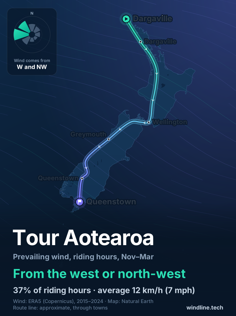
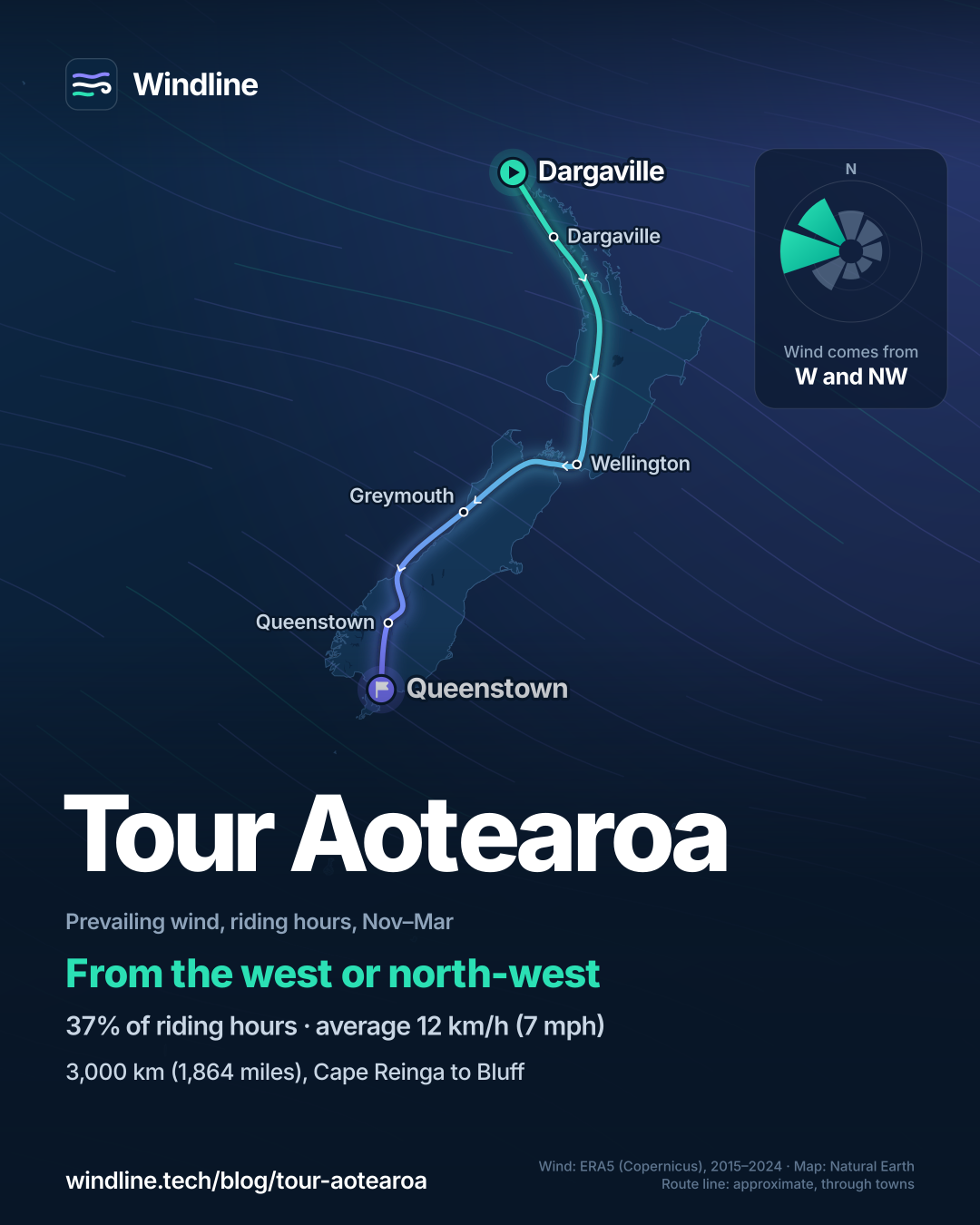
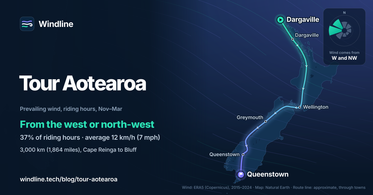
- Past summer winds came mostly from the west or north-west, averaging 12 km/h (7 mph).
- Avoid winter mud and holiday traffic, 24 December to late January.
Definitions
- Great Ride
- One of the 23 mostly off-road trails in Ngā Haerenga New Zealand Cycle Trails, the national network.
- Heartland Ride
- One of New Zealand Cycle Trails' mostly on-road routes through scenic country and small towns.
What is the Tour Aotearoa route?
Tour Aotearoa is a 3,000 km (1,864-mile) bikepacking route from Cape Reinga, at the top of New Zealand, to Bluff at the bottom. Jonathan Kennett designed it to join nine Great Rides and 12 Heartland Rides with the best country roads. It's one of our 10 most popular cycling tours in Australia and New Zealand, in our guide to the world's great cycling routes.
| The route at a glance | |
|---|---|
| Length | About 3,000 km (1,864 miles), Cape Reinga to Bluff |
| Country | New Zealand, North and South Islands |
| Usual days | 5–8 weeks at touring pace (our estimate) |
| Surface | Backroads and cycle paths, gravel, 4WD roads, singletrack, beach sand |
| Navigation | The official GPS file and two pocket guides with cue sheets |
| Best months | Late summer and early autumn; rideable all year |
Which sections do people ride?
There's one official guide per island, so it splits neatly in two.
- Far North: from the Cape Reinga lighthouse down Ninety Mile Beach, by ferry over the Hokianga Harbour, down the Kauri Coast, then by boat over the Kaipara Harbour.
- Auckland and Waikato: through the middle of Auckland, then a coast or hills option from Clevedon to Kaiaua, and the Waikato River Trails.
- Central North Island: the Timber Trail, then the Mountains to Sea trail to the Bridge to Nowhere, where a jet boat covers 32 km (20 miles) of unrideable river to Pipiriki. Then Wellington and the Cook Strait ferry.
- South Island: Nelson's Great Taste Trail, the West Coast Wilderness Trail, the twin glaciers, Cardrona, a boat across Lake Wakatipu, then south to Bluff.
The line changes often: a bridge closure diverts part of the West Coast Wilderness Trail onto State Highway 6, and the new Kawarau Gorge Trail will bring changes near Cromwell. Load the latest GPS file, because auto-routing devices miss the quieter trails.
Want this for your own route? Windline shows the wind for every stretch, timed to your pace. Free. Make a free ride page →
What's the weather like through the year?
Late summer is the driest time; winter and spring bring the most rain and gusts.
Weather across the year on the Tour Aotearoa (Cape Reinga to Bluff), 2015–2024
| Month | Wind from | Average wind, km/h (mph) | Gusty days | Start → high, °C (°F) | Wet days |
|---|---|---|---|---|---|
| Jan | W, NW | 12 (7) | 20% | 14° (58°) → 21° (69°) | 41% |
| Feb | W, NW | 11 (7) | 18% | 14° (56°) → 21° (69°) | 40% |
| Mar | W, NW | 10 (6) | 15% | 12° (54°) → 19° (66°) | 40% |
| Apr | W, NW | 11 (7) | 18% | 11° (52°) → 16° (61°) | 42% |
| May | W, NW | 11 (7) | 23% | 9° (48°) → 13° (56°) | 46% |
| Jun | ~Changeable | 10 (6) | 17% | 6° (43°) → 11° (52°) | 45% |
| Jul | ~Changeable | 11 (7) | 23% | 6° (42°) → 10° (50°) | 52% |
| Aug | W, NW | 11 (7) | 19% | 6° (43°) → 11° (51°) | 54% |
| Sep | W, NW | 13 (8) | 27% | 8° (46°) → 12° (54°) | 55% |
| Oct | W, NW | 13 (8) | 25% | 9° (47°) → 14° (58°) | 54% |
| Nov | W, NW | 12 (8) | 24% | 11° (52°) → 17° (62°) | 51% |
| Dec | W, NW | 12 (8) | 22% | 13° (56°) → 19° (66°) | 49% |
In February and March, riding-hour winds averaged 10–11 km/h (6–7 mph), 15–18% of days were gusty and 40% were wet. Mornings started at 12–14°C (54–56°F) and warmed to 19–21°C (66–69°F). From July to October, 52–55% of days were wet, and September had the most gusty days, 27%. June and July were changeable in direction, with highs of just 10–11°C (50–52°F).
Which way should you ride it?
North to south, as the route is described; the summer wind gives no reason to switch. From November to March, it blew from the west or north-west 37% of riding hours, averaging 12 km/h (7 mph); 17% were calm.
Westerlies made up 48% of hours and easterlies 19%, so expect plenty of side-on wind either way. Winds with a northerly part blew 35% of hours and those with a southerly part 21%, so southbound riders had it behind them more often than in their faces.
These are past averages, not a forecast, and over five weeks even a light headwind adds up (see how much a headwind slows you down).
How do you get there, cross the water and get home?
Buses to Kaitaia no longer have room for bikes, says the route's site, so take a shuttle to Cape Reinga, or fly into Kerikeri and ride about 222 km (138 miles) to the start. Start Ninety Mile Beach three hours before low tide for about seven hours of firm sand.
| Crossing | What to know |
|---|---|
| Hokianga Harbour | Regular ferry, 10 minutes; take cash |
| Kaipara Harbour | Charter boat, book ahead; 2–3 hours |
| Whanganui River | Jet boat, book ahead; about 1 hour |
| Cook Strait | Interislander or Bluebridge ferry; about 4 hours with boarding |
| Lake Wakatipu | Boat crossing; about 1 hour |
Avoid winter, when the tracks get too muddy, and the summer holidays, when roads are busiest. Nights range from campgrounds to five-star lodges (see wild camping rules by country). For the flight home, Invercargill Airport sells bike boxes.
Frequently asked questions
How long does Tour Aotearoa take?
About five to eight weeks at touring pace, our estimate from 65–90 km (40–56 miles) a day plus a rest day in ten. The route's site plans on 5 km/h (3 mph) on rough singletrack, 10 km/h (6 mph) on gravel and 20 km/h (12 mph) on sealed roads. See [how far to bikepack in a day](/blog/how-far-to-bikepack-in-a-day/).
Is Tour Aotearoa the same as the brevet?
No. NZ Cycle Trail says the route can be ridden at any time, over ten days or ten months, alone or in a group. The brevet is a separate, unsupported event in February and March that riders finish in 10 to 30 days. This page covers the route itself.
What do you need to book ahead on Tour Aotearoa?
The boats. The Kaipara Harbour charter runs on demand and must be booked in advance, and the Whanganui River jet boat is pre-booked. Check the Cook Strait and Lake Wakatipu times before you get there. The Hokianga ferry runs regularly for most of the day; take cash.
Get the wind for your ride.
Upload a GPX, add your start time and pace, and see the headwind, gusts, rain and heat for every stretch of the route, timed to when you’ll be there. Free for riders.
Make a free ride page →Sources and method
- Ngā Haerenga New Zealand Cycle Trails (2026). Tour Aotearoa
- Ngā Haerenga New Zealand Cycle Trails (2026). Popular bikepacking routes: Tour Aotearoa
- Ngā Haerenga New Zealand Cycle Trails (2026). Heartland Rides
- Ngā Haerenga New Zealand Cycle Trails (2026). Timber Trail
- Ngā Haerenga New Zealand Cycle Trails (2026). Mountains to Sea Ngā Ara Tūhono
- Tour Aotearoa (2026). Tour Aotearoa
- Tour Aotearoa (2026). Best time to start
- Tour Aotearoa (2026). Transport
- Tour Aotearoa (2026). Route GPS downloads
- Tour Aotearoa (2026). Trail surfaces
- Tour Aotearoa (2026). Route map
- Kennett Brothers (2025). Tour Aotearoa Official Guides (sixth edition)
- Copernicus Climate Change Service (ECMWF) (2026). ERA5 hourly time-series data on single levels from 1940 to present
Route facts are from NZ Cycle Trail, the route's own site (touraotearoa.nz) and the Kennett Brothers' official guides, as checked on 10 October 2026. The length, 3,000 km (1,864 miles), is both bodies' figure and matches our Australia and New Zealand list. Five to eight weeks is our estimate, as in that list: 65–90 km (40–56 miles) a day plus one rest day in ten, so 37–52 days. Best months: the route's site says late summer and early autumn are best, which we read as February and March, the months the brevet is held; NZ Cycle Trail says the route can be ridden at any time. Weather across the year: Windline's own analysis of hourly ERA5 reanalysis (Copernicus Climate Change Service, ECMWF), 1 January 2015 to 31 December 2024, downloaded from the Copernicus Climate Data Store, at four sample points along the route, two on each island (Dargaville, Taumarunui, Greymouth and Queenstown, nearest 0.25° grid cell), pooled. Riding hours are 08:00 to 17:00 local time. Wind is 10 m (33 ft) wind; the directions shown are the two commonest of eight compass sectors, and months when the hours barely agree on a direction are shown as changeable; hours under 5 km/h (3 mph) count as calm. A gusty day has a riding-hour gust of 50 km/h (31 mph) or more; a wet day has 1 mm or more of rain; start is the 08:00 temperature and high is the warmest riding hour. The direction figures use November to March riding hours only, as in our list; westerly means the south-west, west and north-west sectors and easterly the north-east, east and south-east; winds with a northerly part are the north-west, north and north-east sectors, and with a southerly part the south-west, south and south-east. These are averages of past seasons, not forecasts. Contains modified Copernicus Climate Change Service information (ERA5, 2015–2024); neither the European Commission nor ECMWF is responsible for any use of this information. The map's route line joins towns in riding order; it is approximate and not an official route. Conversions use 1 mile = 1.609 km, rounded; °F = °C × 1.8 + 32.
About the author
Wes Thomson, Founder, Windline. Wes Thomson builds Windline, live wind and weather forecasts timed to when riders reach each stretch of road. He built it for his own 2,093 km tour from Pont Drift to Cape Town, and writes these guides with the same focus: what the wind will do to your ride, and how to plan around it.